Well, this may be the first time I am saying this in a long time, but it's looking fairly well for snow lovers. We should see at least 3 inches of snow, and probably more in some areas. However, ice is a huge threat right now, and significant impacts from the ice will occur, such as power outages and severe tree damage. Get prepared now. This is going to be our highest impact storm since 2019, and maybe even 2016. Snow with ice is a terrible combination. The models still haven't come in to consensus though, even less than 24 hours out. It's ridiculous. Winter storm warnings for MoCo and our surrounding counties are in effect right now. It states 4-8 inches of snow and up to 0.1 inches of ice for Upper MoCo, and 3-6 inches for lower MoCo, plus 0.10-0.25 inches of ice. They also said that "snow Thursday morning will be heavy at times with snowfall rates around 1 to 2 inches per hour possible along with visibility reduced to around one-quarter mile at time." The storm will start around 2-4 AM, and end on Friday morning. We will have at least 6 hours of snow, then 6 or so hours of ice, then we will switch back to snow. When talking about models I will also include ice accumulation(if I have that data).
NAM(12km):
The NAM shows heavy snow before turning over into sleet and then eventually tapering off. Models have been trending towards a more lighter event after 2 PM Thursday. It does show less sleet and more heavy snow. In terms of ice accumulation, it practically shows no ice, except for a glaze(<0.01-0.05) in the southern borders.
Snow Accumulation:
The NAM shows 4-7 inches of snow, with more snow in the northern areas than southern areas. The most snow is in the Frederick County/Montgomery County border. The heavy band will drop most of the snow; the NAM shows 2-3 inches before the band and then after the band; totals around 4-6 inches for a lot of the county! This is an improvement and shows that it corrected itself a bit because radar shows the storm strengthening right now and going a tad more south.
European:
The European model shows the heavy snow turning into freezing rain. It does show some scattered snow showers after the main bulk of the storm is done though. Don't have freezing rain totals.
Snow Accumulation:
The European model shows 5-8 inches of snow, with the most snow in NW areas than SE areas. I agree with this model the most in terms of totals. But models are really bad this year, so I really don't know what to choose. Note that this is a 10:1 ratio.
GFSv16:
Snow Totals(someone sent me it who had access to WeatherBell):
This model is a different version of the GFS, yet they are both so different. The GFSv16 is showing over 8-12 inches for MoCo; most areas around 10-11 inches. This is possible if we see heavier snow and less mixing, but there isn't enough confidence to give a clear answer. I think that this would be a boom scenario, but the chances of this happening increase in the northwestern areas of our county, and the chances decrease when you go to the southeastern areas of our county. 10 inches could happen for the whole county, I'm just saying it's more likely in northern areas than southern areas. If the warm air aloft is suppressed enough, this could easily happen. However, we don't know if models are over or underdoing the WAA(warm air advection; pretty much warm air aloft, temps on the surface/ground will be below freezing), since each model has a different opinion and disagreement everywhere. This is a tricky setup, and I don't think I have seen this amount of disagreement this close to the storm. We can hope but don't count on these amounts; just know that it is possible.
GFS:
The GFS shows the storm starting out as heavy snow before turning into a mix, and shows some sort of lull before the precipitation starts again, and it starts to taper off when it's turned back to snow for everyone. I won't be showing the 18z run cause it's completely wrong, and I don't want to mislead my readers. You can check it on Pivotal Weather for yourself if you would like.
Ice Accumulation:
The GFS shows 0.2 inches - 0.5 inches of ice(freezing rain not sleet). This amount would be devastating and would cause major damage, including widespread power outages and extreme tree damage. I don't think we will see this much though, but we will still see enough to cause significant damage.Snow Accumulation:
The GFS shows 4-7 inches of snow across the county, but its generally scattered. NW areas generally have more snow than SE areas though. I don't agree with these totals, its pretty scattered. The GFS has been not so great with this system, in my personal opinion. It has been proven; showing 3-5 inches in Arkansas, and then those areas under that forecast(of GFS) are getting totals much higher than that.
CMC:
The CMC has shifted south. It shows heavy snow turning over to sleet, then turning back over into snow. I don't have ice totals for this model.
Snow Accumulation:
The CMC shows 4-6 inches for our county, with the highest totals west of us. I don't agree with this model that much but I will show it anyways. This is a 10:1 ratio though.
Maps:
NWS:
 |
| Low-end totals(bust scenario, less snow than expected) |
The NWS shows 0.01-0.10 inches of ice for Northern MoCo, where more snow is expected, and 0.10-0.25 inches for Southern MoCo. This is much less than what they have said before thankfully.
Fox 5:
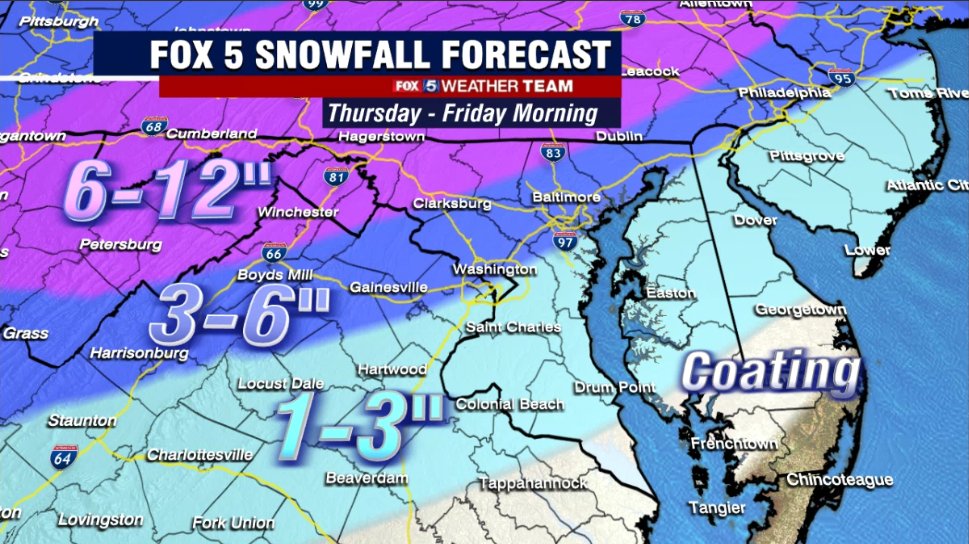
Fox 5 predicts 3-6 inches for the entire county, with more snow in NW areas than SE areas. They said that areas in the 6-12 inches of snow area are closer to 6 inches than 12 inches.
Fox 5 predicts 3-6 inches for the entire county, with more snow in NW areas than SE areas. They said that areas in the 6-12 inches of snow area are closer to 6 inches than 12 inches.
WUSA 9:
Snow Accumulation:
Howard Bernstein shows 6-9+ inches of snow for 55-65% of MoCo, and the southern part of MoCo in the 4-6 inches of snow. He said localized amounts of 10 to 11 inches of snow are possible, but mainly in the mountains(Hagerstown and west).
Howard Bernstein shows 6-9+ inches of snow for 55-65% of MoCo, and the southern part of MoCo in the 4-6 inches of snow. He said localized amounts of 10 to 11 inches of snow are possible, but mainly in the mountains(Hagerstown and west).
Ice Accumulation:
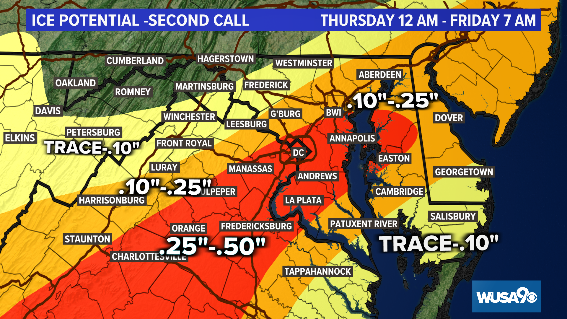
They show 0.1-0.25 inches of ice for most of the county, with the MoCo/DC border in the 0.25-0.5 inches of ice section. This would cause major issues.
ABC 7:
NBC 4:
NBC 4 shows 2-6 inches for most of our county and 6-10 inches in the northernmost portion of our county. They said that ice will be on top of that 2-6 inches of snow in the dark blue section, and in the purple section, it should be mostly snow.
Capital Weather Gang:
Snow Accumulation:
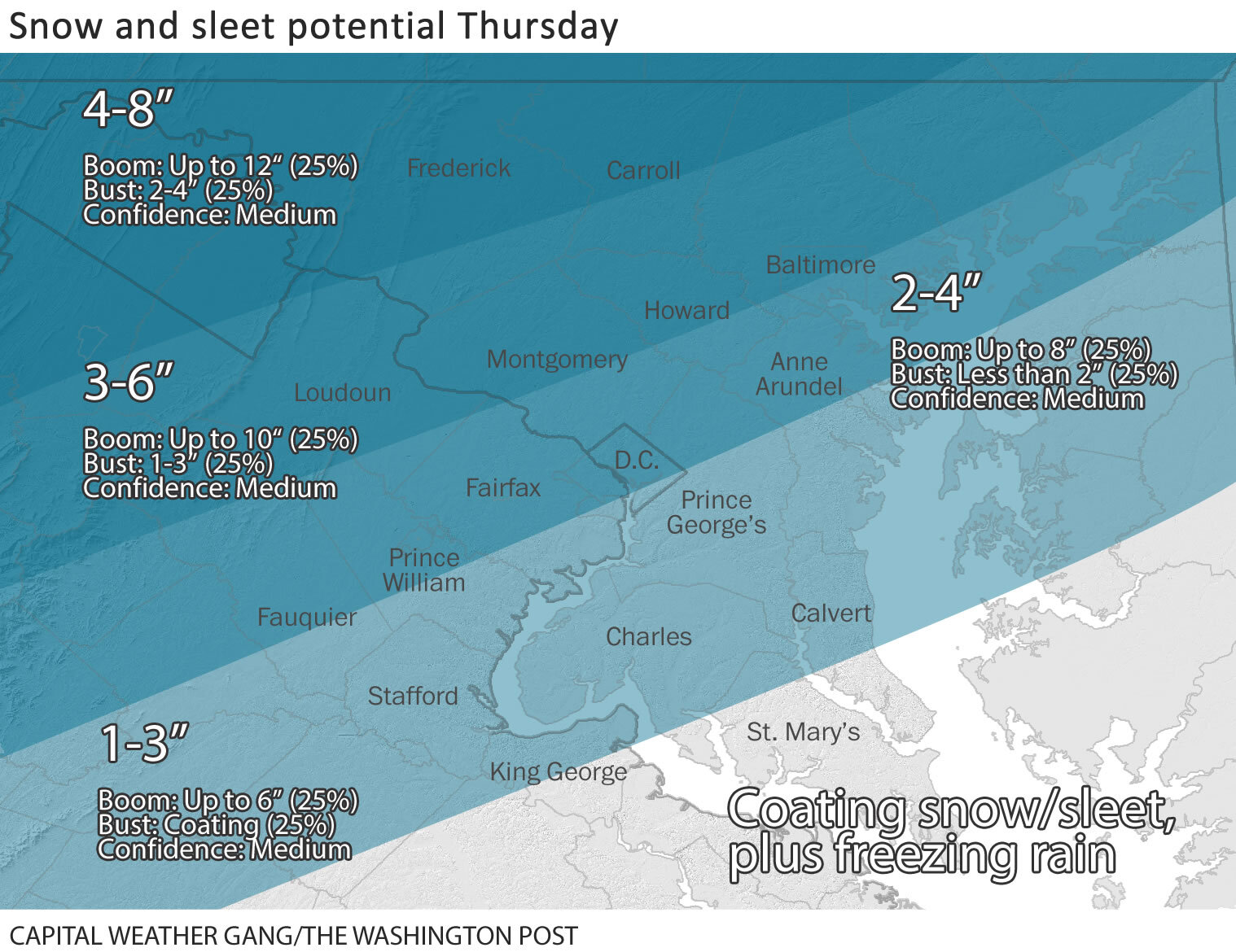
The CWG shows 3-6 inches for most of the county(2/3), and 1/3 of MoCo(southern section) is in the 2-4 inches of snow area. In the 3-6 inches of snow area, a boom would be up to 10 inches, and a bust would be 1-3 inches. In the 2-4 inches of snow area, a boom would be up to 8 inches, and a bust would be less than 2 inches.
Ice Accumulation:
The CWG shows most of our county in the "low threat" region, and our very southern areas in the "Moderate Threat" region, where 0.05-0.2 inches of ice is expected, with a boom being up to 0.4 inches, and a bust being none. If we bust here, we should see more snow. If we boom here, we should see less snow. Temps will remain below freezing the entire time; it is just what is going up in the atmosphere.
QuackyDucc's(my friend's) Snowflake Prediction: 4.5 SNOWFLAKES ❆❆❆❆❄
His statement: "I think that school buildings and virtual learning will be closed tomorrow because of the very high amounts of ice and the future accumulating snow coming."
My Snowflake Prediction(deserves an image): 5 SNOWFLAKES
7:30 AM Update(Thursday):
Unfortunately for snow lovers, it's looking like an ice storm instead of a snowstorm. Heavy sleet and freezing rain outside my window. Prepare for power outages, cause they are likely. I have downgraded my forecast to 2-4 inches in Southern MoCo and 3-5 inches in Northern MoCo.
9:10 PM Update:
Even though MCPS has called virtual classes to continue, I still think that they will reconsider their decision. Both school and office buildings are closed, which should mean that virtual instruction should close, but it isn't. If they don't reconsider, I honestly think that action can and might be taken against MCPS; this is ridiculous, and I am not just saying this as a student. Many other parents and teachers, even those who are generally against snow days agree this was a very poor decision. Temps areawide is 4-8 degrees colder than expected, making the snow's job to rapidly accumulate even easier. Roads and sidewalks will be a trashy mess. This storm has really grown and gotten gassed up in the past few hours; Arkansas was expected to get 3-5 inches and have now gotten 10-12+ inches of snow. The storm is now even further south than what was modeled, giving us the chance for more snow. I think that the potential for higher snow totals is increasing. So for my snow totals, I will change it to 4-8+ inches of snow for Northern MoCo and 3-6+ inches for Southern MoCo(for snow). The warm nose a little bit warmer than expected though, so I don't know... Snowflake prediction dropped to 3 snowflakes; 50% chance of no school.
I have never been this confident in schools closing for a very long time. I would be completely shocked if virtual instruction wasn't canceled. The University of Maryland has closed in-person and virtual activities, and they are located south of us(granted they are supposed to see more ice). They don't close easily at all, and if they closed for the day, it's a good step in the right direction. Temps will be in the mid to upper 20's the entire time, making sure sticking happens on all surfaces. Heavy snowfall rates, often reaching 1-2+ inch per hour rates will help snow quickly accumulate. The heaviest snow should be between 6 AM - 1 PM. Plows won't be able to keep up with the snowfall rates, and snow-covered surfaces are guaranteed. Surface temps will be below freezing the entire time. I doubt offices will stay open. And the wet, heavy snow plus the ice will cause lots of stress on power lines and will cause spotty power outages, and tree damage. Trees are already somewhat damaged from the ice storm we had on Saturday. Cleanup will become much more difficult when the ice starts coming down and compacting the snow. Over 0.5 inches of QPF are expected to fall with this storm. The storm should start to taper off and become lighter in the afternoon hours, and there might be a lull, but roads will be impossible. Power outages are likely as well, and internet providers may fail with the conditions outside. There is not a doubt school buildings won't close. And virtual learning may cease to work as well. If they don't close, there will be accidents galore. Our storm is more south than what the afternoon models showed, meaning that the storm is picking up more moisture and fuel from the Gulf of Mexico. The high pressure is at the right place so the storm won't go north. Heavier snow bands would enforce dynamic cooling, keeping it mostly snow. I predict 3-6+ inches for Southern MoCo(falling in all, not what is on the ground), and 4-8 inches in Northern MoCo. The snow should start in the early AM hours of Thursday, and start to taper off at 12-2p, where it will slowly start to turn into a mix. Mixing will continue into the night and will switch back to snow. The precip might start to pick up at 5pm, but won't be nearly as heavy as the precip in the morning. The snow in the morning will be really, heavy, and I mean it! Totals should be close to storm totals once the band is done(not the exact same since there is still more snow to go). Prepare for power outages, travel will be impossible tomorrow morning, and will start to become better in the afternoon hours, but will still be dangerous. This will be a high-impact storm and will be since at least 2019. Precip should be all said and done by Friday morning. Expect to wake up to a winter wonderland tomorrow.


No comments:
Post a Comment