9:05 PM:
TORNADO WARNING FOR DC. SEEK SHELTER NOW IF YOU ARE IN THE AFFECTED AREA!!
3:35 PM:
There is a flash flood warning for Bethesda and a good amount of Fairfax county. Get to higher ground now if you live in those areas!
3:10 PM:
Severe thunderstorm warning for parts of Northern MoCo, 60 MPH wind and penny sized hail are possible.
2:45 PM:
There is a severe thunderstorm warning for Northern MoCo. 1" hail and 60 MPH wind is possible with this storm.
2:40 PM:
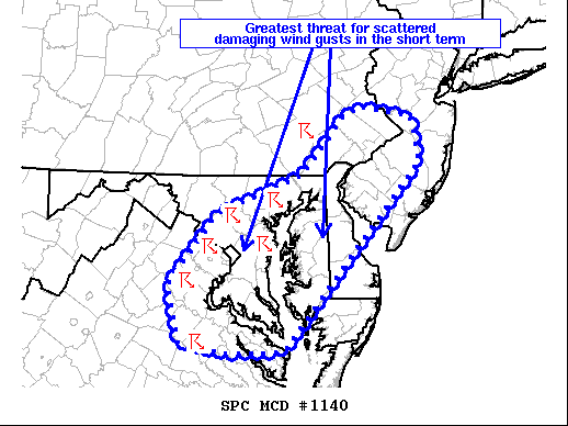
The SPC has issued a mesoscale discussion for most of our area. The area in the circle has the greatest threat for damaging wind gusts(short term).
"Storms have begun to congeal into clusters across
northern VA and MD, with a leading supercell approaching the
Chesapeake Bay. Deep-layer shear of 30-40 kt will continue to
support storm organization, with a mix of multicell clusters and
leading supercells possible. Even though lapse rates aloft remain
modest, hail up to 1.75 inches in diameter has been reported with
the leading supercell in MD. Occasional severe hail may remain
possible in the short term with any storm that can remain at least
semi-discrete. Otherwise, scattered damaging wind gusts will likely
be the primary severe threat as storms continue spreading eastward
this afternoon. The greatest threat for damaging wind gusts should
exist across parts of northern VA into central/eastern MD and DE
where robust heating is supporting MLCAPE of 1000-2000 J/kg and
steep low-level lapse rates. At least an isolated damaging wind
threat may also exist with a small cluster of storms moving eastward
across far southeastern PA into southern NJ, but instability is
comparatively weaker with northward extent across this region owing
to earlier precipitation/storms." - SPC
2:30 PM:
There is a severe thunderstorm warning for southern MoCo. Expect 60 MPH wind and 0.75" hail.
There is a slight risk today for the DMV, and also a flash flood watch for areas east of the Blue Ridge from 2PM this afternoon through tomorrow morning. There is also a severe thunderstorm watch mostly for areas east of the Blue Ridge as well.
There is a severe thunderstorm watch for areas east of the Blue Ridge, including MoCo. Expect 1/2" sized hail(isolated), and wind up to 70 MPH, plus frequent lightning strikes.
There is a slight risk for eastern and semi-northern areas, and a marginal risk for northern areas. The main threats are flooding and wind. In the yellow, is a 15% chance for any area in the yellow to see 58+ MPH winds, and a 5% chance in the green.
This is the flash flood watch. Areas in the green are in the flash flood watch. A widespread 0.5-1" of rain can be expected(areas outside of the watch), but within the flash flood watch, 1-3" of rain can be expected, with localized areas having more.

This is a sounding from the HRRR at 2-3 PM EDT. It shows around 2000 MLCAPE, and a good amount of moisture. The shear is meh, and the lapse rates are generally good.
I'll update this post more often as the day goes on.


