So, nothing has really changed for the white Christmas possibility. We won't see over an inch of snow(unless you live far north and west or in the mountains), so we won't have an official white Christmas. However, today is going to be crazy in terms of weather. Right now, in the morning, there are just mild showers(rain showers). As the day keeps going, the rain becomes heavier, and we will start to see thunderstorms, some even severe. We will start to see downpours, that could possibly lead to flash flooding. We could even see some tornadoes in areas. However, the most likely, and most concerning issue, will be damaging winds(40mph+ possible) and flooding. Our area is under a flash flood watch, which means we could see some dangerous flooding. When we go through the night hours, the severe, rainy weather will start to wrap up as temperatures start to drastically drop. And that folks, is our chance to see some snow. The more west and north you are, the more snow you will see, because of that cold front pushing through faster. And herein lies another big concern: Black Ice. It will have rained a lot by the time temps start to become colder, and there will be enough water on everything that there will be a flash freeze. What about the snow? Snow will easily start to stick as the temps drop. There won't be much snow, as I said before, in terms of accumulations. Some areas in our county may see a coating/dusting, but that's about it. The snow may continue into the morning hours of Christmas, but will most likely wrap up by the afternoon. For the week or so, it's going to be very cold. These are below-average temperatures for December and will feel even colder because we have felt a lot of above-average winter temps in the past 4-6 years(more than average or below average). The only danger I would say for Christmas would be the black ice, other than that I think it will be fine, at least weather-wise. Merry Christmas!
Thursday, December 24, 2020
Tuesday, December 22, 2020
White Christmas Possibility?
Recently, there has been a lot of talk going around about a white Christmas. This is... a pretty rare thing to happen in the D.C area, let alone DC. I think the last white Christmas in our area was in 2009/2010(excluding the mountains). I didn't want to post about this chance because I didn't want to hype everyone up, since a white Christmas is a very hard thing to bet upon. However, there is a decent chance that we will see snow fall on Friday(December 25th). Stickage will be difficult with highs in the 60s on Christmas Eve, so that's why an official white Christmas will be hard(1+ inches of snow). We could see a dusting in our northern areas, but that's about it in terms of accumulation.
And some other good news: We have an active pattern for the month of January. We have frequent storm chances separated by cold(?), dry winter days. That means that we could see some good snow in January!
Thursday, December 17, 2020
End of Storm
Now that the storm has ended, and our backend snow has ended too, I got a storm total of 4.25 inches. I heard that other people in MoCo got 1-3 inches, some getting 4. However, areas north and west got hit with the jackpot. I heard people getting 7-9 inches of snow, and some even getting over a foot. This storm wasn't a bust or disappointing, at least for me, because I had gotten 4+ inches. However, right now, it is so, so, dangerous outside. On a normal day, I would predict 3 snowflakes, due to how icy and slushy it is everywhere in the county. Snowplows came to my neighborhood over 8 times, and they got stuck one time. It is so slippery and icy outside, and the snow isn't much better too. Imagine a sandwich. The snow is the bread, both on the bottom and on top, and in the middle of the snow sandwich, there was sleet and ice. Cleanup will be very difficult, and temps aren't supposed to climb the upper 30's. And the regular rain washed away all pre-preparations(like salt and brine), so in places where the roads weren't supposed to be slick, they are now.
Overall, this storm was more of a mix for us than a snow event. However, in New York and New Jersey, it's really coming down there. I heard that they were expected to get over a foot of snow, some areas potentially getting over 18-24 inches. But for December, this was a good winter precipitation event! We don't usually see this kind of setup or this type of snow for December. The cause for this is that December is supposed to be the coldest month compared to its average temps. I am not saying that December is colder than January or February, January will be colder than December and will have better snow events. But compared to their averages, December is the month that is the most below average. What a great punch to the snow season! 4.25 inches so far. This is almost the same amount of snow I got totally from last year.
Wednesday, December 16, 2020
Snow Reports and Backend Snow
UPDATE: The backend snow is starting to push in as temps start to drop. Our surface low is pulling away, which means that we should be cold enough to support snow/sleet. Read down below for more info.
What Happened in This Storm
This snowstorm started around 9 AM then the snow rate really started to pick up and become heavy at around 10:30 AM and lasted until 12:00-3:00 before the snow turned into a mix. It's now a mix for almost all of the county. So before the mix started, I measured about 4 inches of snow in Gaithersburg, and I have heard a range from 1-3+ inches of snow in MoCo. There is now freezing rain outside my window, and if it's raining but is below 32 degrees, that means that it is freezing rain. When I went outside, the conditions were so bad. There was a mess of ice, snow, and slush everywhere on the roads, even though snowplows and other help came in my neighborhood over 6 times. The plows got stuck at one point, but it was snowing so hard that the help eventually became useless(0.5+ inches of snow per hour) The ground is super slippery and dangerous, and objects that were outside were very slippery. Ice has become a huge concern now, and even after a lot of us switch to rain, a lot of us will switch back to a mix/snow, and temps will drop below 32 for EVERYONE, causing a massive and dangerous refreeze. Please do not travel unless it's necessary. If this was a normal day, a lot of buildings would be shut down. There is also a flood watch in effect for southern MoCo, as everything melting plus with rain will cause major issues with flooding. I have never seen this before in a winter storm. Temps are hovering around freezing as well, so it's very messy.
Backend Snow:
Models are showing some backend winter precip, for Wednesday night and early Thursday AM, which is good for snow lovers like me, because snow will accumulate faster, due to low temps and no to little sun angle(it's night what do you expect?). If what they show happens, and the rain/snow line moves east/south, we could get 1-4 extra inches of snow, however, the models are showing more sleet than snow. We will see. The rain/snow line, according to the models, will more likely move east than south, which is still good.
Tuesday, December 15, 2020
Final Forecast for Wednesday-Thursday Storm
On Sunday, I knew that this storm was going to change a lot, and I was right. Unfortunately, the snow totals over the past 24 hours have decreased, and the chances of us getting double digits of snow are sadly low. However, this snowstorm is still significant, if you live north and or west of Rockville. MoCo is the snow gradient for this storm, but the rain/snow line is pushing up hard. However, here's the (potential) good news. This snow/rain line has been pushing up north, however, its very difficult and downright crazy to predict where the line is going to be. Although the trend seems to be the rain/snow line pushing north, we still really don't know the exact locations where it will stand. Tomorrow morning, in the early AM hours, we will have a much better idea of where exactly the snow rain line will be. The models can only be so accurate. So we could have the gradient go down a little bit.
The watches have turned into a winter storm warning for NW MoCo, and an advisory for southeast MoCo, which was expected with these totals dropping. However, I wouldn't be surprised if the warning extended to include all of MoCo, or the warning gets removed for NW MoCo and is instead replaced with an advisory. With the amount of pure snow dropping, and the amount of mix increasing, there comes another concern: Freezing Rain. There will be more freezing rain in southeast MoCo, however, it won't have as much as an impact compared to NW MoCo, even though they are predicted to get less freezing rain. The main reason for this is because of the temps. In NW MoCo, since the temps are lower, the freezing rain will start to form and accumulate in more areas compared to SE MoCo, where the freezing rain won't accumulate as much. I think that the freezing rain won't have much of an impact.
Enough of words, lets look at some maps!
NWS:


"* WHAT...Mixed precipitation expected. Total snow and sleet accumulations of 1 to 3 inches and ice accumulations of around one tenth of an inch. * WHERE...Portions of central, northeast and northern Maryland and northern Virginia. * WHEN...From 10 AM Wednesday to 1 AM EST Thursday. Snow will overspread the area between 9 and 11 AM, and change to sleet and freezing rain during the mid-afternoon. * IMPACTS...Plan on slippery road conditions. The hazardous conditions could impact the morning or evening commute."

Fox 5:

NBC 4:

ABC 7:

WUSA 9:

- This storm is going to be messy and downright impossible to predict, especially in southern MoCo.
- The heaviest snow rates are between 1PM and midnight.
- Roads and sidewalks will be slick at almost all times, and snow will easily stick.
- Temps will be below freezing during the AM hours and will be hovering over 32 during the afternoon and evening hours.
- The biggest impacts will be north and west of MoCo, where some areas could see 18+ inches.
- Ice accumulation is not out of the game, and will likely happen during the evening/late afternoon hours.
- Most of MoCo might see some pure rain during the early night/late evening.
- We will fully switch back to snow after 8-9 PM.
Monday, December 14, 2020
Wednesday-Thursday Snowstorm Update
The winter storm watch has been extended for all of MoCo, and I expect warnings will be issued soon. Everything, for the most part has held up, in terms of snow totals that is. There were reports of wet snow in a lot of areas in this county, but it was nothing significant. Let's just jump straight in!
Models:

This is the American model. It has changed... somewhat. It shows less snowfall but still shows our area getting about 3.5-8 inches of snow, same trend(more north and west more snow).


This has not occurred since 2016, 5 years ago, during the monster blizzard! This will probably be the most snow we have seen since 2019, or maybe 2016! Places above I-95 are in the high threat area, which means this(in their own words): "High threat of high impact winter storm. Potential impacts include significant travel delays, closures, and threats to life and property. Plan ahead to minimize impact on you and your family."

...WINTER STORM WATCH REMAINS IN EFFECT FROM WEDNESDAY MORNING
THROUGH LATE WEDNESDAY NIGHT...

* WHAT...Heavy snow possible. Total snow accumulations greater
  than 8 inches possible.

* WHERE...Portions of central, north central, northern and
  western Maryland, central, northern, northwest and western
  Virginia and eastern and panhandle West Virginia.

* WHEN...From Wednesday morning through late Wednesday night. Snow
  will most likely overspread the area later Wednesday morning
  into Wednesday afternoon. The heaviest snow is most likely late
  Wednesday afternoon through Wednesday evening.

* IMPACTS...Travel could be very difficult. Potential impacts
  include significant travel delays and closures. Plan ahead to
  minimize impact on you and your family.

PRECAUTIONARY/PREPAREDNESS ACTIONS...

Monitor the latest forecasts for updates on this situation.
...WINTER STORM WATCH IN EFFECT FROM WEDNESDAY MORNING THROUGH
LATE WEDNESDAY NIGHT...

* WHAT...Heavy snow possible. Total snow accumulations greater
  than 5 inches possible.

* WHERE...Portions of central Maryland as well as portions
  northern and central Virginia

* WHEN...From Wednesday morning through late Wednesday night. Snow
  will most likely overspread the area later Wednesday morning
  into Wednesday afternoon. Precipitation may mix with rain and
  sleet at times later Wednesday afternoon and Wednesday night.

* IMPACTS...Travel could be very difficult to impossible.


PRECAUTIONARY/PREPAREDNESS ACTIONS...

Monitor the latest forecasts for updates on this situation.

Reporting wet snow in Gaithersburg!
It's starting to snow here in Gaithersburg. It started around 12:30 PM today, as the mixed rain and snow transitioned into a wintry mix/mostly snow. The snow that is falling is very wet, and the flakes are big. The wet snow is falling at a moderate rate as well and is somewhat accumulating. From other people in this county, I have heard that there are also wet snow in their areas and see it accumulating on trees and decks. This was a little bit unexpected, but not too much.
It is kind of a wintry mix though, and it's starting to become more sleet and freezing rain rather than snow.
Sunday, December 13, 2020
THERE COULD BE A HUGE SNOWSTORM FROM WEDNESDAY TO THURSDAY!
Third Update:
There are now watches in areas. This threat is becoming more and more serious. Northern MoCo and areas west and north of us are also in a watch for Wednesday. They expect over 7 inches of snow possible. There is no watch for southern MoCo and areas south of it(DC included) because there is expected to be a lot of mixing/rain that will bring the overall totals down, which I can understand. However, I think southern MoCo should still get the watch, just maybe for less snow. I am not the NWS however, and they are waiting for models to come in this afternoon, since once we get our afternoon models, we have a pretty good lock on what will be happening. Then, if everything holds up, warnings will be issued soon.
Second Update (before I go to bed):
The chances of a snowstorm are starting to lock in; however, tomorrow will determine what we might be seeing on Wednesday. Tomorrow, most of the models will lock onto some sort of solution. Now, we just gotta hope that the models stay the way they are.

The chances of snow are increasing on Wednesday....

UPDATE: We could see some snow TOMORROW at 10AM-3PM, if you live in the northern part of MoCo. It won't be anything significant though. You might see a coating in the northern areas, but that's about it.
First, I am SO sorry that I haven't been doing any further posts about this. I had a lot of schoolwork, and I just found out about this. But it's ok, I am still gonna post this post. There is a HUGE winter threat from Wednesday to Thursday, and I am talking 6+ inches, winter storm WARNING level. This could be the biggest snow threat since Jan 2019, when I got 14 inches of snow from that storm.
For time's sake, I will only be using 3 weather maps, the NWS, Fox 5, and WUSA 9.
National Weather Service:


WUSA 9:

Fox 5:

Models:
The Possibility of... School Cancellations?
Wednesday, December 9, 2020
A WINTER WEATHER THREAT From Monday to Tuesday?
NOTE: When I started writing this, the Euro model still showed some snow. Now, when this is published, the snow was gone. Still gonna keep an eye on it though. I didn't add any photos because of it too.
That's right folks, you read the title, there is our first actual winter weather threat for this snow season! This seems to be a SNOW threat. However, don't get your hopes up. This threat is about a week away from even happening, and if you have been reading my posts for a while, or have just been following winter weather threats, you know that a lot of threats quickly change, and a weather threat involving 3+ inches of snow will turn into nothing.
So let us focus on our weather threat, eh? From Monday night to Wednesday, the Euro model shows accumulative snow falling, and the amount is 3-6+ inches. I don't exactly... buy this because a winter weather threat with 3-6+ inches possible, in December, isn't exactly... how do I put this... likely. It could easily happen, but it just doesn't feel right. However, December is supposed to be the coldest month, comparing to its average, so it could definitely happen. The Euro is the most accurate model, historically. However, the GFS does not show any snow, at least accumulative, for most of the DMV. I personally think that the GFS run will be more likely to happen, but you never know. The system is kind of in place though. So I think we CAN see some snow, but having more than 3 inches of snow just seems very... fishy.
It's snowing right now!
On 11:29 AM today, snow showers were falling in Gaithersburg, out on my deck. Nothing accumulative, but just nice to see. It was sticking for like 1-2 seconds then melted away. However, for this reason, I don't know if this was snow, sleet, or graupel. Please tell me if you saw any snow today! This what somewhat expected though, many DC weather stations said there would be a chance of some snow today.
Sunday, December 6, 2020
A Chance for Flurries and Snow Showers Monday Morning?
There is a chance for some flurries for Monday Morning. However, DC and most of Maryland will receive flurries. The people who will receive snow showers will mostly be southwest of Maryland. The snow won't be accumulative, but some people, may be able to see a dusting, especially south of Maryland. Our northern areas might be able to see a dusting, but don't count on it.
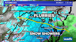
This will have no impact on the day, just will be nice to see. If you live below the yellow line, you will see more heavier snow, but don't expect a winter wonderland. The snow will still probably fall at a light rate. Also, my winter forecasts post will be coming soon. Stay tuned for that, as this winter will be more interesting than usual... maybe?
-
So, most of the news channels have come with their first call for Wednesday. There is still a winter storm watch, which means that the s...
-
 As many of you know, it's supposed to snow this Sunday. How much is still slightly unclear because of where the snow and rain line is....
