Showing posts with label Coastal Storm. Show all posts

Friday, January 28, 2022

Fri-Sat Snow Map and NowCast

6:55 PM:

Snow starting to pick up here and stayed for a while before lightening a bit again. Looks like snow bands are going to struggle to come north, totals on the lower end of the ranges are expected now.

5:45 PM:
I now expect 1-3" for the general DC area, including MoCo. I think the 2-4" accumulations would be a good amount further SE than in my forecast. Southern MD is still on track on my forecast so far. We will see how the evening goes.

5:25 PM:

Moderate snow coming down here, stickage on grassy surfaces. Looks pretty good so far. After sunrise, temps will drop and snow will pick up, allowing for more stickage. Brunt of the storm is NOT over yet.

Sorry I didnt have any time to make a post, I'll just put my final call here. Accumulation should start to ramp up after sunset, and thats when snow will start to pickup. Generally expecting widespread 1-4" of snow throughout the region. I'll have an update at 5:30.

Tuesday, February 9, 2021

Second Wednesday-Friday Storm Update and First Snowflake Prediction

 This storm is a very difficult one to predict, however, I have good news for snow lovers: This should be an all snow event, regardless of amounts. However, this is a long duration storm. And the last long-duration storm, models were very jumpy and had so much disagreement, even 1-2 days out. Watches haven't been in effect yet for us and the general DMV(excluding western MD). Even with that being said, we are at a point where everyone should prepare for an impact on their day. But just how much snow are we looking at? We will try to answer that question using models.

Models: 

GFS:


The GFS shows an all snow event(mixing in western MoCo is a bug because upper air temps below freezing). It shows 2 waves, however. The first wave drops a good 2-4 inches, with less snow in the southern suburbs and more snow in the northern areas. Then, there is a dry period of no snow. Then, we start snowing again, and we into the second wave. This wave drops another 4-6 inches of additional snow onto the snow that already fell. It shows a good 6-9 inches of snow when this storm is said done.

The American model is more northern based than the other models, as you will see shortly. It shows more snow in our NW areas and less in our SE areas. However, in the first wave, dry slotting and not having enough moisture is a problem cause that could easily happen; models don't pick up on it too much. Cold air isn't an issue here though. And the second wave has much more energy and potential than the first one.

European:

The European became less bullish with its storm. Like the GFS, it shows 2 waves, they both start and end at around the same time, and there is a dry period before the next wave. However, the European has shifted south. Again. I will show you the snow map, however, I have some good news along with that.
The European model(sad violin please) shows ONLY 3-5 inches of snow(totally), with less snow in the NE part and more snow in the SW part. However, this is a 10:1 ratio, and the ratio will likely be bigger than this, meaning more snow. Sticking shouldn't be a problem; as most of it should fall in the night. I have some bigger news though. Before the last long-duration storm(Jan 31 - Feb 3), the European model was trending south, and in the last minute, it trended north, giving parts of PA over 30 inches of snow. 
Now, we won't be seeing that much snow, but the bullseye should go NW, giving the DC area the most snow out of this storm. It's called last-minute for a reason. :D


NAM(12km):

The NAM shows an all snow event. The moderate-heavy snow lingers for a while before quickly moving to the south. The second wave seems to miss us as well. I don't think we won't see the second wave miss us, because again; the northern trend. I have never seen it not happen with these kinds of storms. Remember Jan 31 - Feb 3, and how the models shifted to give PA/NJ the bullseye of that storm, some areas getting over 30 inches. 😀

CMC(GEM):

The GEM shows the storm starting as rain(I doubt it will happen, we have a sufficient supply of cold air). It shows the first wave dropping a couple of snow, which is moving SE, then another wave coming from the west hitting us, moving NE, and going off to the coast. 

It shows a good 6-10 inches for MoCo, with more snow in the SW areas than the northern areas. But again... that north trend. I wouldn't be surprised if it shows Northern MoCo getting more than Southern MoCo. If that bullseye moved a bit north, our county would be right in the jackpot. And this is a 10:1 ratio, numbers will likely be higher than this due to the atmosphere being colder.

Maps:

National Weather Service:

Expected:

The NWS is counting in the NW trend, and I think that is what people should do for this storm because it always happens. It shows 6-8 inches for all of MoCo. I like how they are playing with this storm.

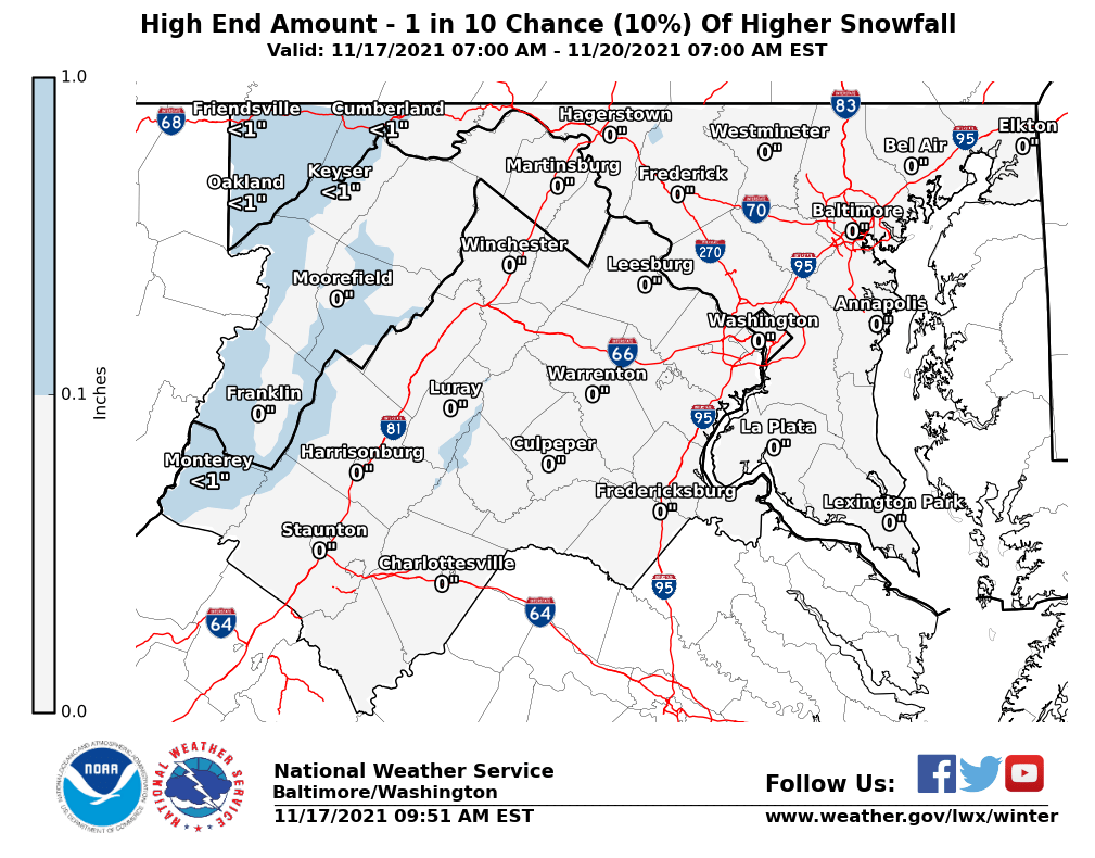
High End:

The NWS shows 8-12 inches of snow for the whole county if this storm were to boom.

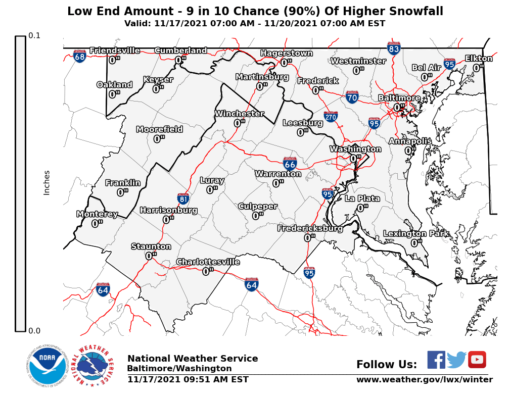
Low End:

The NWS shows 2-3 inches for most of the county, with 3-4 inches for super NW MoCo. This would happen if this storm busted. 

The National Weather Service shows a moderate threat of a winter storm for the entire region from Thursday-Friday. This hasn't occurred since 2019.


Fox 5:

Fox 5 shows a good 3-6 inches for our county. Mike Thomas said that they are on the low end of totals compared to guidance due to many unanswered questions. I understand why, but that northern trend should at least put us in the 4-8 inch range.
 
WUSA 9:

Note: this is only until Thursday evening, additional snow will fall on Thursday Night - Friday. They show 3-5 inches for upper MoCo and 1-3 inches for the rest. I think they are going a little conservative with the snow totals, but that is fair.

Capital Weather Gang: 
They show 3-7 inches for Western MoCo and 2-6 inches for the rest. I agree with this map more than the other ones, cause it does give the potential for over 6 inches. 

NBC 4 thinks 1-3 inches for the first wave and 1-3 inches for the second wave. Storm totals across the county add up to 2-6 inches of snow. Again, it's good to play conservatively for your first call as more data comes in. ABC 7 also thinks 3-6 inches of snow. 


So what do I think? For my first forecast, I think that we MoCo will see 4-8 inches from this storm. We won't probably see any kind of mixing, and we should have sufficient cold air in place; meaning that the snow to liquid equivalent ratio will be above 10:1 like it normally is(good for snow lovers). Surface temps should be cold enough to support accumulation and to help us, snow lovers, even more, most of the snow should fall during the night, where there won't be a sun angle to hinder accumulation. This will be a high impact storm, and you should take it seriously. The second wave of snow will probably bring more snow along with it, as it is more powerful. The NWS has a moderate threat for the entire region(not just the northern or southern part, hasn't happened in around 2 years or so). This might be the biggest snow of the season for Southern Maryland, and maybe even since 2016. 

Snowflake Prediction: 

For a snowflake prediction, there is still so much we don't know about, but for now, I stand at 3 snowflakes. School buildings will probably close on Thursday, but offices may not, because there will be a lull between the transition to the second wave, and I think that Montgomery County will try to do a delay or something so that they can go to work at the lull. There is still so much that we don't know yet, and we have to see live conditions to make a proper prediction. I will make a final call tomorrow with a stronger snowflake prediction. I will also be doing a nowcast for this storm, while its raging on, so you can get live conditions and updates.


Sunday, February 7, 2021

Sunday Storm Recap and Many Storm Chances


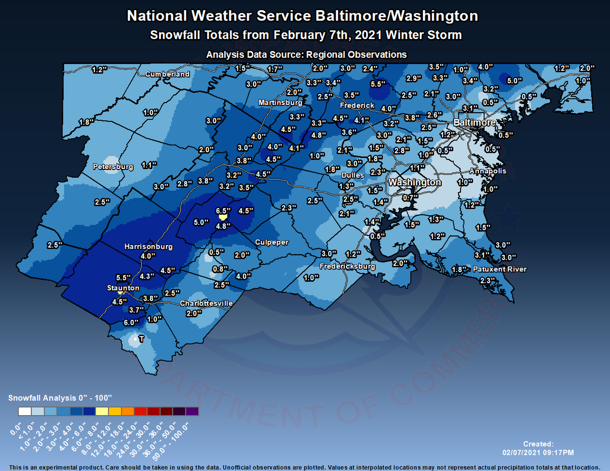
So overall, this storm wasn't too bad, even though the snow totals up there look bad. According to this map, around 1-3 inches of snow fell, but in localized areas, from what I have heard, around 2-5 inches of snow fell. I myself measured 4.2 inches of snow, which includes compacting and melting, bringing up my winter total(so far) to 17.2 inches of snow. It started out as rain and turned into wet, heavy flakes. Snow won over the marginal temps and accumulated on any untreated surfaces, but quickly melted as precipitation became lighter/stopped. This storm ended as mixed rain and snow, at least for me. Now, as temps quickly drop, any wet surface will become ice rapidly. A flash freeze is likely. My forecast was a little bit less than expected, but it still verified! 

But now, I want to talk about the storm chances we have coming up. We have a slight threat for Wednesday-Friday. This is our next system we will be monitoring.


The NWS shows a slight winter threat for Wednesday into Thursday, for Northern MoCo, and no threat for the I-95 Corridor(southern MoCo). Now, I won't go into too much detail(since this post is mainly for the Sunday storm recap) but all wintry precipitation types are on the table for this. It all depends on the placement of the Arctic ULL, the more south it is, the more cold air and snow we will get. This is looking like a moderate to possibly heavy event(in terms of snowfall), but anything could change this far. The main part of this event for snow/wintry precipitation is between Thursday-Friday, as you will see by the image below.


The NWS shows an enhanced threat for Northern MoCo and a slight threat for the I-95 Corridor(southern MoCo). The bulk of the wintry precipitation seems to be here, and this is why we might have moderate-heavy snowfall totals.

But there is one more threat I want to talk about. And yes, it falls on a Sunday(let's keep this a weekly thing). And although this is far out, if this threat were to materialize, it would definitely be a significant storm, with some of the models showing heavy to even SEVERE snowfall totals! Now, this is very far out and will change over the course of the week, but it's definitely something to watch. We have at least 2 storm chances before Valentine's day. 


Saturday, February 6, 2021

Final Sunday Storm Update

 There are winter storm warnings for the entire county that starts at 3 AM Sunday and ends at 12PM Sunday, with 3-6 inches, and additional details that will be stated at the end of this post(my opinion and more details). This storm is playing out like a spring storm, as surface temps are marginal due to the temps being in and around the 50s in the past 2 days or so. The timing of this storm is early morning Sunday - Sunday afternoon. It may start as rain, but will turn over into a wet snow. Even so, heavy snowfall will be able to cool the ground fast and will stick on untreated surfaces.

GFS:


The GFS shows the storm starting as rain for southern MoCo, then shows heavy snow taking over any other precipitation for everyone. 


Unfortunately for us, snow lovers, it shows 1-2 inches for the county, with 2 inches in Damascus. This is a huge disappointment compared to the last run of this model. But we still have more models.

European:


The European model shows the storm starting as moderate-heavy snow then shows it transitioning to a mix before it goes off into the ocean. Each picture skips 6 hours though, so we will see more snow than what it seems here.

It shows 4-6 inches for our county, with higher snow accumulation in the southeastern areas. However, in our northern areas, temps will be colder, so more snow will accumulate, whereas, in our southern areas, temps will be warmer, so while there might be more precipitation in general, less snow will accumulate. We will see though.


NAM 12km:

The NAM(12km) shows the storm starting out as rain, which will cool the atmosphere enough to support snow. Then, it turns over to snow and stays that way until the storm is over. It shows heavy rates after the transition to snow.


The NAM shows a good 4-5 inches of snow for our county. It shows more snow west of us than east.


National Weather Service(NWS):

Expected Amounts:


The NWS shows a good 4-6 inches for the whole county, and for our surrounding counties as well. It shows around a 40-50% chance of us seeing 4+ inches.

High-End Totals:


The NWS shows 6-8 inches of snow if a boom were to happen(more snow than expected). This would happen if our bands were widespread and heavy, temps were a little bit colder than expected, and if we see more moisture.

Low-End Totals:


The NWS shows less than 1 inch of snow if we had a bust(less snow than expected). This would happen if temperatures were too warm to support snow, or if we got robbed of our moisture.

Justin Weather:


Justin Berk(he runs Justin Weather) shows us in the 3-6 inches range, and additionally in the "possibly higher" area too(entire county in both). He said that inside the pink circle(possibly higher), where we are, it depends on the heavy bands and local temps for what can accumulate. He also said that thundersnow is possible around daybreak. The "possibly higher" region has the highest chance of seeing very heavy bands and rapid accumulation, increasing the storm total.

Capital Weather Gang:


The Capital Weather Gang shows 1-4 inches of snow for our county, with 4-8 inches if the storm booms, and a coating to one inch if it busts. Overall, with what some of the models have been showing today, I understand why they haven't really increased their totals.

This map from Matthew Cappucci, a meteorologist at the Capital Weather Gang, shows MoCo in the greenish-blue circle, where frontogenesis will enhance snowfall rates, with rapid accumulation and very heavy snowfall rates, for around 3 hours. He also said that thundersnow(mainly for New York) can't be ruled out and is a possibility. That is a rare, yet epic phenomenon in winter storms.

Fox 5:

Fox 5 shows 3-5 inches of snow for the entire county. They stated that snow will come in around 3-5 AM for us and for our surrounding counties and that the heaviest snow will be between 6-10 AM.\

WUSA 9:


WUSA 9 predicts 2-4+ inches of snow for our county, with a small portion of Northern MoCo in the 1-3 inches of snow range. Their map hasn't changed yet, so I will keep updating these maps when new ones are made.

ABC 7:


They didn't give a map, but still gave us a range! For the general area, ABC 7 thinks 2-4 inches of snow. They noted that we might start, and even end as rain.

NBC 4:

NBC 4 shows 3-5 inches of snow for the whole county, with higher totals possible. Everything will be out by 2-3 PM. 

They also show a timeline of how bad conditions will be outside. On Sunday morning, they think that there will be heavy snow with low visibility, plus untreated surfaces will be slushy. By the afternoon hours, they think that surfaces will be wet/slushy, and by night, untreated wet roads(also includes snow-covered and slushy roads) will be frozen over and will be slick.


Overall, what do I think, in terms of totals? 3-5 inches for the whole county, with higher amounts possible if bands set up just right(so 3-5+ inches). This will be wet, heavy snow. Temps will be hovering at the freezing mark, so some accumulation will be canceled, but heavy rates will make up for it. And, as reassurance for us snow lovers, temps right now are 5-8 degrees colder than expected, which means surface temps aren't as warm, which means that it will be easier to support accumulating snow. Models don't do a good job at forecasting dynamic cooling as well, so during those heavy bands, temps could drop a couple of degrees colder than the freezing point(below 32 F). As it is looking right now, MoCo, and the general DC metro area, seems to be a sweet spot for this storm. The snow will come in the early morning hours. The heaviest snow should be between 6-10 AM. The snow should be out by the afternoon hours. We should be getting some of the heavier bands, and that's why a lot of forecasts have us in the higher amounts possible area. The NWS says that we should expect 1-2 inches per hour rates in heavier snow bands. We have a good chance of starting as rain, and then turning back to snow. However, we could easily end as rain too, but I think the chances of that happening are low. Take note that temperatures will rapidly fall below freezing after the storm, causing a flash freeze. Temps will not go above freezing on Monday, and will be in the teens; and may even go into the single digits! This storm won't have much of an impact on schools, because I don't think that this event will be able to close offices, which is needed to close schools. This snowstorm, on my snowstorm rating system, will be a moderate storm. Even with that being said, you should be taking this storm seriously. Please avoid any travel, unless needed. Stay safe everyone, and I hope you enjoy the snow! We have many more storm threats coming up soon...


Friday, February 5, 2021

Superbowl Sunday Storm Update

 As I said earlier, the models are trending northwest. And it's not done yet. We are now about 2 days out from this storm. But as you saw earlier last week, even when we get close to the storm, the models can still can be all over the place with disagreement left and right. This storm will be quite short, starting in the early morning hours, and will move out around the afternoon-evening hours, but heavy snowfall rates will make up for the short duration. Winter storm watches have been issued for the entire county, including surrounding counties, which starts at 9 PM tomorrow and ends at 3 PM Sunday. As it is looking right now, southern Maryland seems to be getting the most snow out of this event. We will start looking at snow totals from models, since we are not that far out. 

GFS:


The GFS shows the storm starting as light snow at around midnight Sunday, then shows it ending around the afternoon hours. Although this storm is short, it shows heavy snowfall rates to compensate for it.


The GFS shows 3-4 inches for the entire county and 3-6 inches for the general DMV. Although I do agree with this map, I also think that if we get really heavy bands, our county can possibly push over 6 inches. Surface temps + temps in the air are marginal, which means hovering at or above freezing. Even with that being said, there seems to be not much mixing with this event. If it's snowing fast though, it can cool down surfaces enough to become cold enough to support snow. We will see tomorrow's runs and decide.


European Model:

The European model shows the storm starting as moderate-heavy snow around Sunday morning, then shows it tapering off in the afternoon hours. It does show a little bit of mixing in southern MoCo, but I don't think that's the case, since upper air temperatures remain below the freezing mark. It has moved northwest(just like the other models) for this storm.

The European model shows 3-5 inches of snow for our county, lower totals in Northern MoCo, higher totals in Southern MoCo. The trend is shifting north for us, so I wouldn't be surprised if it changes so that Northern sees more than Southern. 


NAM(12km):


The NAM shows the storm starting out as rain, but then turning over into all, heavy snow. The rain will cool the atmosphere enough to support snow, so thats good if it happens. It shows the storm starting at around midnight and shows the storm ending by the evening hours. Now, if this went right, this could dump a lot of snow on us. The next image below shows high, unrealistic(at this point totals). The NAM does have a wet, snowier bias, so keep that in mind.


The NAM shows 6-8 inches of snow in MoCo alone! Now, would I love to see these totals? Yes. But do I think its realistic? Possibly. I don't think we will see totals that high, but once tomorrow comes and we have more information, we will have a better idea of what to expect.


MAPS:

Capital Weather Gang:


The Capital Weather Gang shows 1-3 inches of snow for the entire county. However, they did state that based on the model trends, their revisions are more likely to go upward(more snow) than downward(less snow). For the first call, it is good to stay conservative, and I understand why they have generally low totals.

National Weather Service:

The NWS usually goes conservative with their maps at first, but this is looking pretty good compared to other maps. It shows 4-6 inches for the upper third of the county and 3-4 inches for the rest. Overall, a range of 3-6 inches. I agree with the map the most, however, I am not sure if the upper side of the county will get more than the southern side, since that is what models are showing right now, but we will see.
WUSA 9:

WUSA 9 shows almost all of our county in the 2-4+(plus means higher amounts possible) inches of snow range, with a small sliver of northern MoCo in the 1-3 inches of snow range. 

Fox 5:

Fox 5 shows 3-5 inches of snow for our entire county(sorry for the bad quality). I actually think this is one of the best maps because they are really factoring that north trend and going somewhat confident with their totals, and where they reach.

(I couldn't find ABC 7's and NBC 4's maps, I will be including them plus another map tomorrow)

So how much of an impact will this have? Not much, but the morning commute on Sunday could be difficult. This is wet, heavy snow, but since temps(including surface) are marginal, snow might have a hard time sticking. If we have heavy bands, snow probably will stick on untreated surfaces. This event will be a short-duration event, unlike the last one we had. Heavy snowfall rates will make up for it though. The watches may turn into advisories or warnings; it could really go either way. For MoCo, my first prediction is 2-5 inches of snow, with higher amounts possible and likely if heavy bands intensify and fall. I won't say anything else, since I need tomorrow's afternoon models to say otherwise. 


Tuesday, February 2, 2021

Summary of Sunday-Tuesday Storm

 This storm was crazy, due to the long duration of it. I haven't seen a storm that lasted over 2 days in a very long time. 4-8 inches of snow were reported across the county. I myself reported 7 inches of total accumulated snow(not what is on the ground). This storm wasn't a bust. But the big winners(in Maryland) were in northern Frederick County, where someone measured 20 inches of snow. This was a historical storm in the rest of the northeast. The highest totals were close to 40 inches! In terms of accumulation, totals were at the lower end of expected snow. We had a sort of a bust at first, then a boom! The reason why we picked up as much as we did was because of the heavy banding that came from the storm in PA, often containing 1-3+ inches per hour rates. These bands dropped visibility and rapidly added snow accumulation. On Sunday, the snow steadily fell and dropped 3-5 inches, then on Monday-Tuesday, heavy bands dropped additional snow to increase the totals we are right now. On Monday, in the morning hours, heavy sleet fell. Sleet was falling so hard that it was downpouring it. We also had freezing rain too. Then, we switched to all snow in the afternoon hours. 

Snow totals across the DMV.


Sunday, January 31, 2021

Nowcast for Sunday - Tuesday Storm + Snowflake Prediction for Monday and Tuesday

MCPS HAS ANNOUNCED THAT ALL SCHOOLS WILL BE OPENING ON TIME, AND THAT A RE-EVALUATION WILL BE DONE AT 5 AM.

ALSO, THE MAPS ARE NOW OLD, AS I USED THE IMAGE ADRESS, AND NOT A SCREENSHOT OF THE IMAGE, SO THE MAPS DONT SHOW MUCH.

POWER OUTAGES HAVE BEEN REPORTED ALL ACROSS MARYLAND AND THE DMV. HERE IS SOME INFORMATION TO HELP YOU: https://weather.com/safety/winter/news/2020-03-02-what-to-do-if-your-power-and-heat-go-out-in-the-winter#:~:text=During%20An%20Outage%3A&text=Then%20report%20the%20outage%20to,Huddle%20under%20extra%20blankets. https://poweroutage.us/

STATE BY STATE RESOURCES:
https://poweroutage.us/area/state/maryland

https://poweroutage.us/area/state/virginia

https://poweroutage.us/area/state/west%20virginia

https://poweroutage.us/area/state/delaware

ANOTHER UPDATE: As 0z models come in, I will be adding more models. Make sure to go to the bottom of the article to read the latest information on what I think.

UPDATE: Warnings have turned into advisories for the entire county. Advisory lasts until 10 AM Monday.


This storm wasn't really a bust, but it was a bit disappointing, to say the least. We got dry-slotted(who would have guessed) around the afternoon hours, but we still got as much snow as what was forecasted, just in the lower end of totals. Totals ranged from 2-5 inches in the county(as of 6 PM), with more snow northeast and less snow southwest. As of 6 PM, the status for school is open on time, explicitly said by MCPS. They said they will do a re-evaluation at 5 AM, though. For all schools to be canceled(including virtually), offices(in-person) need to be completely closed. However, the criteria for that is much higher than the criteria that are needed for in-person school to close. Now, we will turn into a wintry mix, including ice, and then eventually switch back into snow on Monday. Northern MoCo is in a warning until 6 AM Tuesday, the southern portion; midnight on Monday. The question is: Will we see enough ice and snow to close offices? We will try to answer that using maps.


The NWS shows 1-3 inches of ADDITIONAL snowfall(not storm totals) for our county. The western/southern portion of our county is in the 1-2 inches portion, while the rest of the county(northern-eastern side) is in the 2-3 inches of snow accumulation. With 2-5 inches on the ground, this would bump up our totals to 3-8 inches. However, areas in the 1-2 inches area(for our county) will have additional totals closer to 2" than 1. The closer you are to another zone, the likelier your totals will be similar to theirs. The NWS shows a 60-80% chance of at least 2 or more additional inches, and a 30-60% chance of 4 or more inches of additional snow(see images below).

Chances for 2 or more inches.

Chances for 4 or more inches.


This is a boom scenario, which means totals are higher than expected. This is also additional snowfall onto the snow totals. It shows 6-8 inches for most of the county, with Damascus in the 8-12 inches of snow range. This will probably not happen, but if it did, it would be 5 snowflakes. 


The low end totals show no additional snow accumulation for most of the county, with the northern and eastern portion in the less than 1 inch section. I don't think this will happen either.


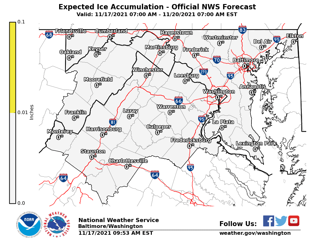
Now this is what everyone is watching. The entire county is in the range of at least a tenth, all the way up to a quarter inch of ice. We are also flirting with the 0.25-0.5 inches of ice, which is enough to cause serious and major impacts, including countywide power outages. A quarter-inch of ice is very hazardous and can easily cause power outages, plus break tree branches. A tenth of ice will make surfaces very slippery, plus combined with the snow we have, power outages are more likely. If we see totals closer to the high end, I could very well see no school. 


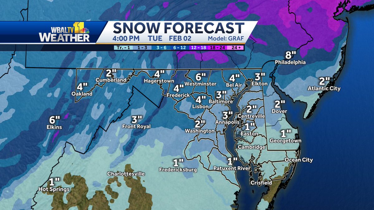
This model is by the GRAF, which is an excellent, yet relatively new model. It shows 3-6 inches for most of the county, with a small path of the county in the 1-3 inches range. Since people in that range are so close to the 3-6 range, they will likely see totals in the high end of the range, or even might get in the 3-6 inches range. Generally, northeast areas will see more snow than southwest areas of this county. This is the best model for this situation. Storm totals would become 3-9 inches if this played out.


The NAM shows the dry slot fill in with a mix, which falls at a moderate-heavy rate. During the time period of 12 PM - 2 PM, it shows the mix turning into snow for everybody in the county. Then, the snow CONSISTENTLY falls at a moderate-heavy rate for almost 20 hours! Then, the snow starts to taper off a bit, and the snow becomes scattered. It comes back a couple of times and then is gone.


The NAM shows 4-7 inches for the county, with the most in NE areas, like Damascus. Along with the 2-5 inches that fell today, that's 6-13 inches. 

GFS:

The GFS shows the mix/freezing rain turning into moderate to eventually heavy snow, around 10 AM. The bulk of the heavy snow will be between 1 PM - 4 PM, but moderate snow will still linger into the night. The GFS shows 4-6 inches of additional snow, on top of the snow that fell today. This will bring our totals up to 6-11 inches(see image below). It shows the most accumulation in Damascus.


CMC(GEM):


The Canadian model shows the second part of the storm starting as snow, then shows a brief period of a mix, then turns back to all snow. After it turns back to all snow, it shows on and off snow falling. All is said and done by 1 PM Wednesday. It shows an additional 3.5-6 inches falling. Combined with what we have now, that's around 6-11 inches of snow(see image below). The most snow accumulation is in  Northeast areas, like Damascus.


Snowflake Prediction:

2 Snowflakes: ❆❆

(Special Version: 50% closure[school buildings], 25% chance for offices to close)

Tuesday:

12:10 PM Update:


As you can see by the arrows, the snow band is generally moving in a southeast direction. In the next couple of hours, if you haven't seen a heavy band yet, you probably will see it soon. Snow is still persisting in Frederick, Fairfax, and even Washington counties. Half of that snow band is still in PA.

11:50 AM Update:

The snow axis has moved west, which means it's looking better for snow accumulation in the DC area. Moderate snow still continuing somewhat west of us. One long snow band from the north, hitting Loudoun and Fairfax counties plus MoCo(mainly northern and western areas) is generally moving south, but the radar shows unpredictable movements. Sudden drops in visibility and fast snow accumulation on roads are likely in these heavy bands. We will likely see another coating, all the way up to 2 inches in the next couple of hours. Winds are gusting 25-40 MPH, blowing snow.

8:30 AM Update:

Winter weather advisories have been extended for everyone until 1 PM because of lingering snow bands. Snow is accumulating rapidly on any untreated surfaces, due to the really heavy snowfall rates. I feel like by the end of the storm, about everyone should have totals similar to what was projected earlier. Visibility is really low outside. Avoid any unnecessary travel. Winds are also picking up and drifting snow. These are near-blizzard conditions.

Monday:

10:30 PM Update:

The main bulk of this event is over. We will see some snow accumulations, but it will be mostly light, with additional snow accumulations only up to one inch. It is super icy and snowy right now, but even then, crews will have some time to work on the roads. Winter storm advisories have been extended to 9 AM Tuesday, but snow showers will likely persist for much of Tuesday too. The latest NAM(3km) shows snow showers persisting until around early Wednesday morning(12-3 AM). It only shows 1-2 inches of additional accumulation though. My prediction for school tomorrow is 2 snowflakes, meaning that offices will likely be open(25% chance of closure) and school buildings have a 50% chance to close. I am not really leaning either way though. 


5:30 PM Update:

New bands are forming all across the DMV. Bands far away shouldn't be tracked because they are getting stronger and then weaker and it's not reliable to do so anyway. We have many new bands forming as we go throughout the evening and night hours. Heavy snow bands are unleashing very low visibility and even snow accumulation on treated surfaces. My neighborhood roads with salt still had snow accumulation as we got the bands. Salt is not becoming as effective. If you are traveling, it is going to be very hard to see and snow will rapidly accumulate on the roads. Stay safe everyone.

5:00 PM Update:

These heavy snow bands will be coming in waves. Once one of them is here, it will snow at a heavy rate for some time, then start to snow at a less heavy rate. We still will have snow during those periods when we are waiting for the bands, so don't worry! This will keep happening as it goes through Tuesday. Snow coming down at a heavy rate right now. In fact, it's snowing so hard that parts of the LWX radar are being blocked and are showing dry conditions, when in fact it is snowing there!

4:00 PM Update:


The heavy band has made it into our county! Over the next hour, it should be moving in a southwest direction, as the arrows point. Expect a sudden burst of heavy snow and visibility to suddenly drop.

3:40 PM Update: 


Multiple heavy bands from the north are moving into our area and pushing down south. The arrows represent the direction the bands are going in. We will see some of these bands. All of these bands have very heavy snow and are likely to fall at rates of 1-2+ inches of snow per hour.

3:20 PM Update: 


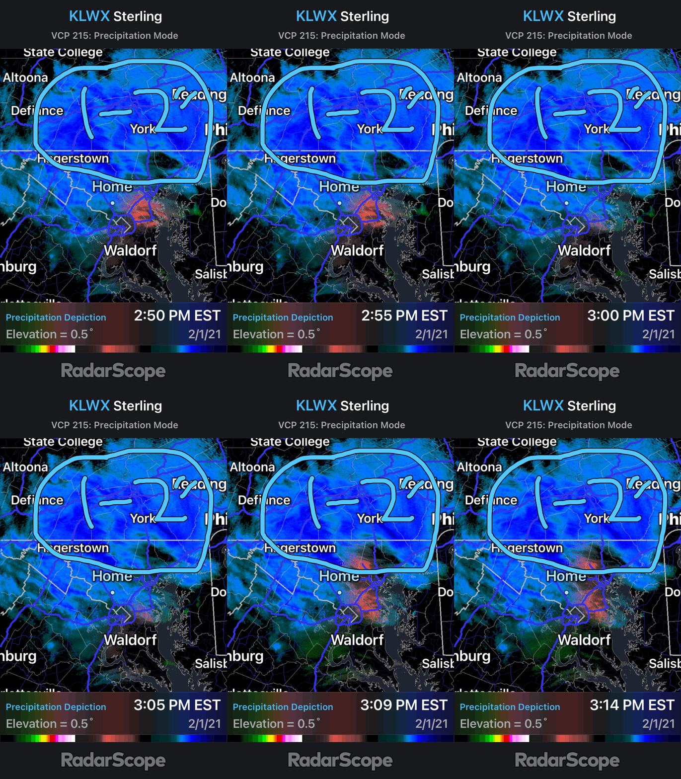
The storm is throwing even MORE heavy bands at us from PA! The areas in the circle that says 1-2" are right now seeing the snow bands from PA(dark blue represents heavy snow). These snow bands have 1-2"+ per hour snow rates! Areas in the band will see a sudden and drastic decrease in visibility as heavy snow falls. The bands are making their way to the south! The storm is throwing everything it can at us.

3:00 PM Update:


This is what the radar is showing right now.  The circled area is where the dark blue colors are, and that indicates that "thumping" is happening in that area, otherwise heavy bands. Areas in those bands can expect snowfall rates to fall at 1-2 inches per hour! They seem to be moving south in our direction, so I think that at least our northern section of our county will see that heavy band.

2:20 PM Update:

The storm system has become vertically stacked. 700 and 800 MB lows are over the surface low. What does this mean? This means that this storm is not going away anytime soon, and this also gives it the potential to stay through Tuesday. This will likely result in more heavy snowfall.

1:50 PM Update:

The atmosphere is cold enough for almost everyone in Maryland to see snow now! The heavy banding in SE PA is rotating into Maryland, going in an SW direction. But, this is more impressive. The European Model shows 5-8 inches of ADDITIONAL snow after the storm is all said and done. Models have been trending colder for our area, but even then you should be skeptical of these numbers. Didn't want to show precipitation on modeling cause it is happening right now. Still an encouraging sign for snow lovers, regardless!

10:45 AM Update:

The fact that they haven't called anything yet makes me less confident that they will do anything...

9:50 AM Update:

Winter weather advisories have been extended until midnight on Tuesday. Conditions are just getting worse and worse, as we turn into snow in the afternoon hours. Precipitation is going to start to pick up, along with gusty winds. This increases our chance for an early release to 67%.

9:30 AM Update:

I have reports from all over the county about how icy and snowy it is outside. There is already a sheet of ice underneath any surface, plows came to my neighborhood 3 times and dumped pounds of salt, and yet it's still so icy with snow. Freezing rain picking up a bit now, as temps are well below freezing. Damascus is super icy, and many roads in Northern MoCo haven't even seen a plow yet. I will increase it to 65%. 


9:00 AM Update:

Light to moderate freezing rain falling in Gaithersburg, not really melting the snow because of cold temps, should switch over to snow in the afternoon hours. I will now increase my chances of an early release to 55%.


8:30 AM Update:

Models are showing heavy bands of snow during the afternoon hours. The coastal low is closer to the coast and is getting pulled back west. This will result in colder air(temps right now are already colder than what models show), stronger and gustier winds, snow bands and showers through Tuesday, additional accumulation, and if we start as a mix, we will turn into snow by 10 AM - 2 PM. I think that we will see totals like in the snow maps we saw on Saturday, even if it is on the lower end(5-10 + inches). Some snow will probably fall in the morning hours, but the main bulk of the accumulation should be in the afternoon. This will cause big impacts on the evening rush hour. Not to mention, the gusty winds that will be blowing snow that's falling and on the ground, lowering visibility and increasing the risk of an accident(if snow on the ground gets blown into your car, your window can break and injuries can easily occur). I am almost CERTAIN advisories will be extended to at least go through the afternoon hours, especially in NE MoCo. We could even see warnings(if we get a little bit more than expected)! I still won't change my percentage UNTIL we start to see our snow fall, though, but once it does, and if everything seems right, I will increase it.


7:20 AM Update:

Right now, we are in a lull of precipitation. As the day goes on, we will start to see snow. About 1-3 inches are expected, with 2-4 inches in the NE part of the county. Snow will have no problem sticking though, as temps are WELL below freezing. The county has announced that there will be a full day of school, but they are monitoring conditions and will make an update if it is needed. This means that there is a chance for an early dismissal, however, until we start to see our main precipitation come over and see how conditions evolve, I will have to leave it at a 50% chance.

Sunday:

11:45 Update:

With almost all of the models showing an additional 3-6+ inches of snow for our county, the bulk of it falling in the afternoon, I think we can get an early release. We could easily still get a closure, but I still think that I don't want to lean either way because they are going to try to fit in as much school as they can. It's STILL snowing in Gaithersburg, and even though we are more likely to turn into a mix in the next couple of hours, there's already 0.5-2 inches of snow on the ground from snow accumulation after 5 PM. It's going to get REALLY bad around the afternoon time, and even for offices, I think that not calling an early dismissal would turn dangerous fast in the evening commute. Traffic could be endless. Overall, I think we will see an early release but remember... this is my first time predicting virtual impacts. I might be wrong. Plan for a full day of work/school.


Why early release chances are included: Snow is more likely to fall in the afternoon hours, due to a higher chance of the mix fully turning into snow by then. Ice is going to make things very difficult to clean up, as in northern MoCo, the lights keep flickering, and we even haven't turned into freezing rain yet. 

10:40 Update:

Our neighboring counties are starting to make the call, which is good for us, because if all of the other counties do something, MCPS will be pressured into doing something. Frederick County has completely closed schools, even virtual learning. Prince George's county has called an early dismissal for online instruction. If a county south of us does something to the school day, that is good, because the storm impacts them less, whereas compared to us, we have a higher impact. I think an impact is very plausible and possible at this time.


9:50 Update:

Right now the coastal low is forming around Myrtle Beach, South Carolina, and it is going to go to Theta-E, which is located east of Maryland, right along the line between the ocean and the USA. This is good for snow lovers because this makes coastal storms stronger. It is further south than the models were showing, possibly giving us more snow. And by now, the warm front at 700MB right along I-95 was expected to go north of the PA line and give us a lull, but snow is still falling in Northern MoCo. I feel like we will see more snow tomorrow, and there will be a decent amount.


Original Statement:

I honestly think that even with the models showing less snow, with the snow we have right now, the Monday commute will be a mess, with wintry weather continuing into Tuesday. This is a long-duration type of storm, so snow and ice will keep piling up.  It could really go either way. Precipitation will be mainly scattered right now(7-9 PM) as we turn into a wintry mix. Precipitation will switch back and forth. Right now, we are seeing a sort of lull in a lot of the county. Main precipitation will come back after 9 PM, snow or wintry mix. If heavy bands from the north wrap around and travel south enough to get to us, we could easily see lots of snow. I will keep updating this as the hours go on.


Featured Post

Archival of Blogger and Move To Substack

Hello everyone, I'm making this post as a formal gesture that I have fully moved to Substack and will not be using this website anymore....