Showing posts with label Nor'easter. Show all posts

Friday, January 5, 2024

1/6/2024 Small Wintry Mix Event


We have a small wintry mix event for NW of 95 that will result in some minor impacts, with impacts increasing the further north and west you go. A low pressure system will track northeastward off the gulf coast and into the Delmarva as it intensifies over SE VA. Precip will overspread the DMV in the morning, starting out as wintry precip for most. Areas along and E of 95 are expected to see very minimal accumulations and a quick transition to a cold rain. 

As the event progresses, strong WAA will warm the 850 mb temps to above freezing as a warm nose is pushed northwestward, while cold air is still at the surface. Unlike a few days ago, this opens the potential to overall wintry precip rather than just snow to rain. These 850mb temps will vary, with the coldest temps being in the mountains and W of the Blue Ridge. Here, the primary ptype will likely be snow. It is very likely that everyone E of the BR will warm enough to see a wintry mix of sleet, freezing rain, and rain(more wintry precip the more NW you go).


The confidence of this storm is generally very low even this close to the event, due to the extremely tight gradient setting up near the RS line; this is going to be a nowcast event. A 1-3 degree difference will make or break this setup. Due to the preceding temps and low wetbulb temps, wintry precip(where it does happen) should stick pretty easily. The best confidence for significant snow is W of I81, the Catoctins and westward, into the mountain counties. Although it seems surface temps were colder than modeled, the 850 mb temps according to IAD sounding look just as modeled, this doesn't really mean anything yet. Nonetheless, most of the region will see some wintry precip, with accumulations starting as soon as you head N and W from the cities.


Making a snow map for this event was difficult, but here are my general thoughts as of now:

Everyone E of 95 sees all rain, this is medium-high confidence. At the very most a couple of flakes may mix in at the border parts, but very little to no wintry precip is expected here. 95 and just NW is looking to see a T-1"(trace does not mean measurable snow). I think everyone here sees at least wintry precip falling, even with a quick transition to rain. This area also has low confidence, and will setup the start of the very large gradient. The more snow accumulation the more NW you go. Immediately NW of DC/Balt(outside the cities), there is some chance for some very minor ice/snow accumulation. This will be washed away quite quickly however.

The light blue zone(for areas closer to DC) I think will see enough snow/sleet to accumulate, as well as some ice accumulation. This area is extremely uncertain though, with the lowest confidence. The dark blue zone is the same idea as the light blue, but more snow/sleet and more ZR. Again, extremely low confidence in these areas; small temp differences can make or break this.

However, the light blue area near I81 is likely going to see large ice accumulations(potential of 0.1-0.25"+ here). This area is W enough to have enough cold air at the surface but WAA will quickly turn most precip here into freezing rain. The predominant ptype here looks like freezing rain, but some sleet/snow will likely fall.

The purple area is much more confident as this area likely stays snow long enough to see moderate accumulations(3-5"). Even here, there is a slight concern that mixing will cut down a bit, but any mixing shouldn't be too long. The predominant precipitation type here is snow. The red area is the bullseye and the mountainous areas. These areas have higher confidence.


Here are the current onset and warning maps, WSWs are up for just E of I81 and westward, as well as Frederick/Carroll Counties. WWAs are all the way down to the metros, primarily due to ice concerns. Generally, if you can avoid travel near I70/I81, do so, but closer to DC, travel shouldn't be too bad. We see an areawide E of I81 transition to mix and then rain by 10AM to 2 PM.


Thursday, January 6, 2022

Final Forecast Jan 6-7 Storm

Good evening everyone! The models have trended for lower totals and lower QPF, however this event still shouldn't be too bad, with 2-4" still expected. I'll only be showing 3 short/medium-range models(NAM, NAM NEST, and HRRR), my snow forecast, the NWS forecast, and my snowflake prediction.


NAM NEST:


The NAM NEST(higher-res version of NAM) shows a heavy band hitting a lot of the area between 1-3 AM. NAM 3km actually looks pretty accurate to what we are seeing on radar, except that the fact that radar has the storm a bit more amped. Anyways, shows widespread 2-4", with some localized areas getting higher than that.

NAM:


The NAM shows a pretty decent solution for this storm, with 3-5" north and west of DC, and 1-3" DC and south. It shows a moderate-heavy band that hits many of the DMV, with the highest totals being north and west.


HRRR:


The HRRR shows light-moderate snow for most of the storm, with a moderate-heavy band moving through between 1-3 AM. Compared to both of the NAMs, this model is more conservative for the snow totals, with 1-3" for most of the region(some areas 2-4"). 

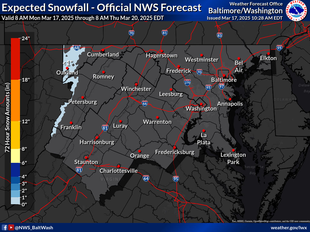
NWS Snow Forecast(forecasted, and high-end all in respective order):

Expected Snowfall - Official NWS Forecast


My Snow Forecast:


This is my snow forecast. Latest guidance shows heavier snowfall(2-4") being reserved to north and west of DC. Most of MoCo is in the 2-4" area, except for very southern MoCo. The reason I went 1-3" was because of dry slotting, a common thing which happens in Miller Bs such as this one. The initial low pressure weakens, and the new one forms. When this happens, it allows dry air to come in, which would reduce the snow totals from this storm. Hence the 1-3" area was expanded. If you live in Northern MoCo, and any areas N & W of it, I think you should be fine for the dry slotting. Will have to watch closely.


My Snowflake Prediction: 

3 snowflakes

55% chance of a closure, and a 75% chance of a delay

The reason why I think we have a good chance of closing is because of the temperature, and winds tomorrow. Temperatures will not rise above freezing for almost all of the county tomorrow, meaning that whatever stuck will stay there. Additionally, it is supposed to be windy tomorrow, and a fluffy snow is expected, meaning that blowing snow is another hazard that needs to be worried about. Even though totals are more on the lighter side, it will be more than cold enough for the snow to immediately start sticking to untreated surfaces. If we get the high-end amounts, I am more than confident in a closing. As of now, I am a bit unsure on whether to lean towards a delay, or a full-on closing. I will change the chances as new information comes in. Needless to say, I am pretty sure there will at least be a delay.


Wednesday, January 5, 2022

Snow Threat Jan 6th Night - Jan 7th Morning

Good evening everyone! The NWS has put a winter weather advisory for the entire region, with 2-4" expected, and up to 5-6" in isolated areas. The usual trend of north and west getting more snow is back. Models have been all over the place with this event, and especially with the low placement. The snow will arrive tomorrow night, and there will be enough to shovel and plow. There won't be as much as 1/3 gave to SoMD, but there will still be a moderate amount of snow. Heaviest snow will be around midnight for Northern MoCo, with rates up to around an inch per hour. Where the frontogensis bands setup is where the heaviest snow is going to be. According to Sterling's AFD a short term winter storm warning may be required if a band persists over a specific localized area. Temps before the event will be much colder than 1/3, and it will be below freezing the entire time the snow is falling, so snow will have no problem sticking on untreated surfaces. This snow will be easier to shovel as it is a more dry, fluffy type of snow.

GFS:


This is the model that shows a more southern solution. 18z run had a more amped storm with less confluence, allowing the storm to go more a bit more NW. Still shows 1-3/2-4" for most of the region with 4-6" in SoMD.


NAM(High-Res, 3km):


The NAM is a more northern solution, and shows more snow for our area in general, 3-6" for most areas north of DC and 2-4" south. The influence of dry air for the northern part of our region may cut down on totals. That will be the more difficult part, finding out where the dry air sets up. 

NWS Forecast:


(sorry for low quality image, blogger wouldn't let me adjust the size of the high-quality image)


My Snow Forecast:


Snowflake Prediction: 3 Snowflakes


With temperatures being cold enough the whole day to support snow(<32 for most of the county), and there being 2-4" during the start of the rush hour, would pretty much confirm a delay. Additionally, if the heavier bands setup over our county, giving some areas warning level snow, that would take much longer to cleanup and cause more issues. The new superintendent seems to be more lenient with giving out snow days, at least so far, which is good. There is a pretty decent chance for schools to be closed tomorrow, and depending on how models go tomorrow, that chance may increase or decrease.


Sunday, January 2, 2022

First Significant Snowfall of the Season

 Update: All schools in MoCo have closed for tomorrow
I have a Twitter account, follow for more weather related news: https://twitter.com/shark_wx
 
Overnight, models have trended towards the better for snow lovers. The model runs have only been getting better and better for snow. All of the models have either trended NW, or stayed in the same place. Also, every model has been trending more amped(powerful), and reserved(slower), which means that when we get snow, its gonna be dumped on us. The storm on radar also looks more amped and NW compared to what the models were showing, which is very good. Southern MoCo is in a WSW(3-7" expected), and Northern MoCo is in a WWA(2-4" expected). Near blizzard conditions are possible with this storm. If NW trend continues, Northern MoCo will be in the WSW too. Snow rates between 5a - 11a tomorrow are the heaviest, with rates being 1-3", and with <32 temps, it will not take long for the morning commute to descend into chaos. I'll be making my snowflake prediction for school closings, and my snow forecast!

Euro:

 Euro shows 8-10" of snow for MoCo, and it's solution is similar to the 21z RAP.z


The Euro ensemble has >90% for almost all of MoCo to see 3+ inches of snow. The extreme northern part of MoCo has a 80-90% chance, which is still VERY high.

SREF:

This is the SREF mean. It shows 6-12 inches for MoCo and south. At the start of the storm, it will take a while for the ground to cool, but oh it will cool very fast once it really starts to snow. This isn't kuchera, so it will be inaccurate. At the start, snow ratio will be less than 10:1, but when the heavy snow starts to pick up, and temps start to drop, the ratio will be more than 10:1. Overall, the SREF mean shows a significant snowfall for our area. 


NAM:


(Credit: to dollar monkey#6663 for telling me this)

I don't trust the snow amounts and the ptype map on the NAM, but my friend saw something on vorticity that was really interesting. The area that was circled could potentially have a heavy snow band in that area, which would increase totals. Bands always form north of what is modeled, and this one looks to do just that. There is a tail at 700 mb vorticity, and that usually means that north of it gets a heavy snow band. Hence, I think that a heavy snow band will form in this area. The first image is an alternative scenario where the band sets up further south, and the third image is a scenario where it sets up further north. I have a more confidence for the third image(FGEN at 700mb supports this, second image), and the band will set up in the DC metro region. This was something interesting I found on the NAM 12km.


GRAF:


This is the GRAF model. I don't have access to this model, but I was able to find it online. It shows 6-12 inches for almost all of our region, including extreme southern Frederick county and south of that. It shows 12-18" of snow for parts of eastern MD and DE, which might be a little too extreme. I am not sure how well this model does, but I heard that it does really good with these types of events. This shows a widespread significant snowstorm for the DMV.

RAP: 


This is the RAP. It shows a widespread 6-12", with SoMD getting the highest totals. MoCo gets 8-10" of snow, which is a VERY substantial amount. I would say that this wouldn't be as extreme, but the storm as of 5:52 PM looks much more stronger and amped on radar, with more moisture, so this could indeed verify.

My Snow Forecast:


This is my second call for snowfall for the January 3rd event! It's pretty self explanatory what the totals are, so I'll go over why I made it like this. I feel like this storm will over perform. On radar right now, the storm is more north, and is much more amped than high-res models were showing, which is a very good sign for this storm to boom. I was talking about the possible location on where the heavy band sets up, and that would increase snow totals significantly due to a good thump. Because of models overall trending for the better, and the observed storm is doing better than what was expected, I made the snow totals more widespread and increased them. DC and south is going to receive 6-12" in my opinion because of the heavy thump of snow and possible banding forming there. I think 5-9"+ for central and semi-northern MD(MoCo) because of the storm going a tad bit north with much more moisture. There is a possibility that the 5-9 area could see more than 9 in localized spots because of heavy banding moving north. Snow rates will be extremely heavy with this storm, and will overtake ground temperatures quickly. It will start off as rain before quickly turning into snow.


As for the snowflake prediction: 4.5 Snowflakes


I am very confident in schools closing for this system. 1-3" rate snowfall during the rush hour is a recipe for disaster. Crew won't have enough time to fully treat the roads, and the initial rain will wash off some of the salt and make it less effective. Winds are also going to be very gusty, further creating a visibility problem. I just cannot see how schools will open, even on a 2 hour delay.


Wednesday, March 31, 2021

April Fools Snowstorm Update

5:50 PM Update:

As many people saw snow from a heavy snow band that pushed through our area, many bands are still coming through and still forming in PA. We have a chance for snow bands to come through our region throughout the rest of the day and night, and even a chance early morning tomorrow! As north winds gust and pull in cold air and as the sun sets and temps drop, some of these bands may fall when its below freezing, and may cause some accumulation! Not much is expected though, only up to an inch; up to 2 inches at the very most. Sun angle issues will be removed, and if the temps are below freezing accumulation could easily happen. Keep hoping! This was better than a lot of models were saying.

7:30 AM Update:

As the main course of precipitation moves out of our region, there is still chance for some flurries/snow showers with mostly light but sometimes heavy-moderate snow to come south from PA throughout the day and into the night. In the night, it may be below freezing when they come. North winds will create showers in the afternoon that may have snow mixed with them. Snow was confirmed on radar in northern Frederick and Carroll counties and may have coated the ground there. However, mixed snow reports go much more further east and south than that, and I can confirm one here too. Anyways, we still have a chance to see some snow, mixed with times throughout the day if you don't live in a northern place and/or aren't an early riser. There is a chance for some accumulation, mainly after sunset when temps will start to plummet towards freezing. It won't be much unless that precip is heavy.

Tomorrow is the beginning of April... and to start it off we have a chance for some snow to fall. Models have been jumping back and forth with this system, and 12z runs weren't looking that good, but 18z runs look a bit better. The cold front is coming through, and has reached into western Maryland at 5 pm. I don't know if this is earlier or later than expected, but I'll assume this is around expected. I'll keep updating this specific post if anything major changes. Let's jump right into the models!

 GFS:

The GFS shows rain turning into an isolated part of snow before the main system moves out, and shows lingering rain/snow showers staying for a while before completely moving out. After hour 18(7 AM), the 540 line is south of our county. This is good because it means that our county is generally suitable to get snow. The lingering snow/rain showers between hour 21-27 should generally be snow, possibly mixed with rain.

Now I want to talk about the isolated snow spot at hour 18. We have northwest/north winds up to 700 mb in this sounding, which will bring in cold air. The precipitation type maps plus precip type on sounding all say snow. However, we are under the 540 line at this time, which isn't favorable for getting snow. We also have temps well above freezing. This would likely not be all snow even for Damascus and would probably be mixed with rain. These are somewhat heavy precip types and will cause dynamic cooling, something the models don't handle well so we will see how this plays out.

The GFS shows around an inch for that area in that spot of snow at hour 18. I wouldn't think this much would fall, since rain mixing would hinder with accumulation, but this could happen if we saw less mixing!


NAM(12km):

The NAM shows all rain on the ptype map for all of MoCo, but the thing is its glitching a bit. At hour 18(7 AM), most of the county is under the 540 line and still rain. Even if not snow, it would still at least be snow. 

This sounding shows north/northwest winds up to 700 mb, and temps at 39F. Even on the precip type guess, it says snow. It would be difficult to have pure snow with this sounding, so there would likely be mixing with rain. Even so, the ptype map is wrong and it should show some snow above 540 line.

It shows no accumulating snow for our region except for western Maryland, but this map is glitched.


European:


The European doesn't show any wintry precip for any of our region, but there is a high chance that in the break between hour 24 and 30 that there is some sort of wintry precip, mainly for our northern areas. I cannot see soundings or 540 lines so it's harder to interpret this.

The Euro(10:1 ratio NOT Kuchera) shows no snow except for northwestern Frederick County.


This event is very difficult to forecast. A small difference in temps could mean snow or no snow. A cold front is pushing through and a second cold front will push through tomorrow as well. If we don't get snow from the main event, we may get snow from the lingering snow bands after the main course of precip, and it may be below freezing when we might get them. For a snow forecast... it's too difficult to make one.  We might not see any accumulation at all or we could see 1-3 inches. North and west of MoCo has the best chance, but this storm favors more inland than more north(although being more north always helps)! Models won't be useful past this point, and its better to use other tools. This may be the last snow threat of the year. Either way, April Fools!


Sunday, March 7, 2021

Mid-March Weather Pattern Update

During La Nina winters, something usually comes up in March that is wintry-weather related, even if the winter that year has so far been not so good for winter weather(in terms of amount). Take the winter of 2016-17 and 2017-18 for example! Our snowiest days those years were in March. Well, we have something coming up in mid-March! This week will be the warmest week we will have SO FAR this year, but then it starts to get colder and temps will drop after Friday afternoon.


The CPC has below-average temps for the entire DMV during the time period of 3/14 - 3/20 and has a strong chance for below-average temps(>50%), and for the below-average temps to be more stronger(colder). The southeast ridge(warm air) seems to be losing. This outlook reflects the negative EPO, which is one of the most driving teleconnections in the weather. The negative EPO, as you might have guessed, brings a colder solution to the eastern US.
The CPC also predicts above-average precipitation for the entire region(except for western Maryland but that area is still in the "above-average precipitation" area), and it's not a small chance either(moderate to strong chance of more precip than normal, and for that quantity of precip to be more). This increases our chances of snow with the cold air in place and an active storm track, the chances for storms to produce wintry precipitation increase.


EPS(European Ensemble):
Now, the reason I zoomed it out so much to include all of North America is to focus mainly on Alaska and to see how it affects us. You see the orange in Alaska moving through there? That's a sign of a ridge forming there. What does that mean for us in the Mid-Atlantic and Northeast? It means that around next weekend, a negative EPO will form, pushing down cold air from the Arctic to us. This will cause a cold week from March 15-20, but models are trying to break it down by the end of that time period. Even then, I wouldn't be surprised if the models keep trying to delay the possible date of the -EPO breakdown further, since they have been doing that this year.

Also, today morning, Judah Cohen tweeted that the message from the American and Canadian ensembles is to not put the snow removal tools away yet and that starting next week, there is an increasing chance for snow. The more north you are, the higher chance you will see snow. He also shared some images that I will show.
This is the GEFS(American ensemble) for 3/13-3/17. It shows blue(the darker the blue, the higher the chances for snow and cold temps are, the darker the red, the lower the chances for snow and cold temps are) awfully close to MoCo, and for the western and NW suburbs of the DMV, the blue(more snow and colder temps) is present there!

This is the GEFS, and it shows blue for a lot of central and northern Maryland, with the highest chances of snow(darker blue) in the NE suburbs of the DMV. This is for the time period of 3/18-3/22.
This is the GEPS(Canadian ensemble) for the time period of 3/13-3/17 (same scale as the GEFS, darker blue = more snow and cold temps, darker red = higher temps and less snow). It shows blue for almost all of our county, and for the DMV, in our northern areas(not favoring west or east). It's mostly light blue, but it is still a good sign for snow lovers.
This is the GEPS for the time period of 3/18-3/23. It has blue for a lot of Virginia and Maryland, and the areas in the DMV that are the most into the blue would be our western and northwestern suburbs. This also includes the mountains!

As you can see, the ensembles are starting to have the confidence for more snow and colder temps for all of the region, and especially for our northern and western suburbs. This could be winter's last shot, but winter could extend all the way into April, and maybe even May to a certain extent. Winter isn't over yet as I think I can push above-average snowfall this year; all I need is 1.1 or more inches. We already have some good systems to track next week. For snow lovers, there's one last hope. This week is going to be very warm though. Highs will reach well into the 60's, and models are showing temps even getting into the 70's in some areas! Spring isn't here just yet though.


Monday, February 8, 2021

Wednesday to Friday Storm Update

We have gotten to the point in storm tracking, where instead of something might happen, something is probably going to happen. This event will be a long-duration event(probably not as long as the Jan 31-Feb 3 event though), lasting over 24 hours. This storm has a lot of potential to bring good snow to us, and possibly even increase our seasonal snow totals to become above-average(for a La Nina, that's pretty good)! However, we still have a lot that we don't know about. We don't know the exact amount that will fall, who sees what, things that we often don't know from this point out when we are looking at winter storms. The first part of this storm has gotten into the range of short-range models, but even with that being said, global models are our best bet at this very moment.


GFS:


As you can see, the GFS remains mostly all snow for us, with some mixing at times. There are 2 waves, Wednesday-Thursday, and then another wave on Thursday-Friday. It does show a dry period between the wave transitions. Temperatures will stay below freezing(on the ground) this entire time. 


The GFS shows a widespread 7-14 inches, with more snow in the NE parts than the SW part, when this storm is all said and done. It has been caving towards the snowier, colder European model.

European:
The European Model shows non-stop heavy snow, without any break. This model is our best bet at the moment, and it is going bullish for this storm.

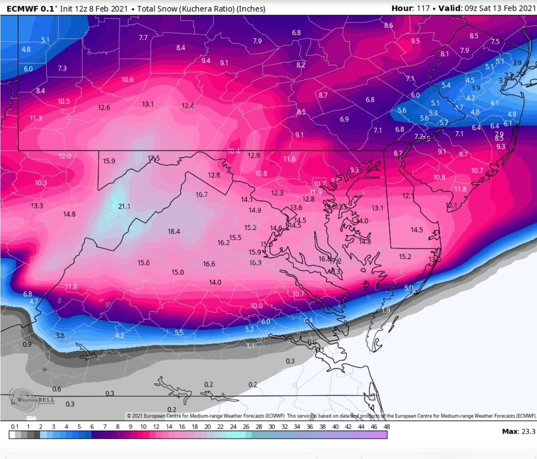
(Image from Weatherbell, someone who had access to it showed it to me). I wasn't kidding when I said the European model was going bullish with this storm. It shows 10 to 16 inches of snow! And it shifted this storm south as well. With the last minute NW trend(hopefully), this would make the DMV, and MoCo the bulleye of this storm! All of the ensembles show snow for us too, which is a good sign.


CMC(GEM):

The CMC shows the first part hitting us hard with heavy snow, but then shows the second part of the storm going to the south and missing us. However, due to the last minute NW trend, that part of the storm should go right up to us, making us the bullseye. It still shows some significant snow, even with the second part missing us, as you will see below.

The CMC shows 6-9 inches just from that first part, which is pretty good. As I said, I think the bullseye will shift NW, right to us.

The NWS has released their first call snow map. Note that they usually go conservative with totals at first.


The NWS says 4-6 inches for most of the county, and 3-4 inches for a part of Southern MoCo(most of it in 4-6 inches of range). And this only includes totals from Wednesday to Thursday(7 PM). We still have so more snow to go from Thursday night to Friday afternoon. The next part will probably drop at least 1-2 inches more. And I know that is what they are thinking because of the winter storm threats they have issued.


This is their storm threat for the first day(Wednesday-Thursday). They shows a medium confidence, low impact threat for both Southern and Northern MoCo, and a high confidence, low impact threat for the Alleghany Front. Snow is supposed to move in during the afternoon-evening hours, so the threat is understandably low. However, as you will see below, they think that there will be more of a threat on Thursday-Friday.

From Thursday to Friday, the NWS shows a medium impact, medium confidence winter storm threat for the entire region! The models show the bulk of the snow accumulation to be here. Temps won't rise above freezing the whole time.


My biggest concern is that the storm won't shift northwest, and will instead go to the south, giving us ample moisture. I don't think it will shift too north to the point where we don't get that much snow, that's much more unlikely than the storm staying south. The blocking in Canada will create a ULL to cross our region, ergo giving us a long-duration storm. This storm is mainly looking all snow, however sleet and ice are defintely on the table. I expect watches and warnings to be issued soon as we get closer to the storm. Right now, I would consider canceling any unesscary plans from Wednesday-Friday. Offices could close, but I won't make a prediction until tomorrow, cause I need more information. Snow will move in during the afternoon-evening hours of Wednesday, and will start to taper off Friday afternoon. These heavy bands will give us some good snow. As it is looking now, at least 3 inches is a good bet. I will make another post tomorrow and give more details.


Featured Post

Archival of Blogger and Move To Substack

Hello everyone, I'm making this post as a formal gesture that I have fully moved to Substack and will not be using this website anymore....