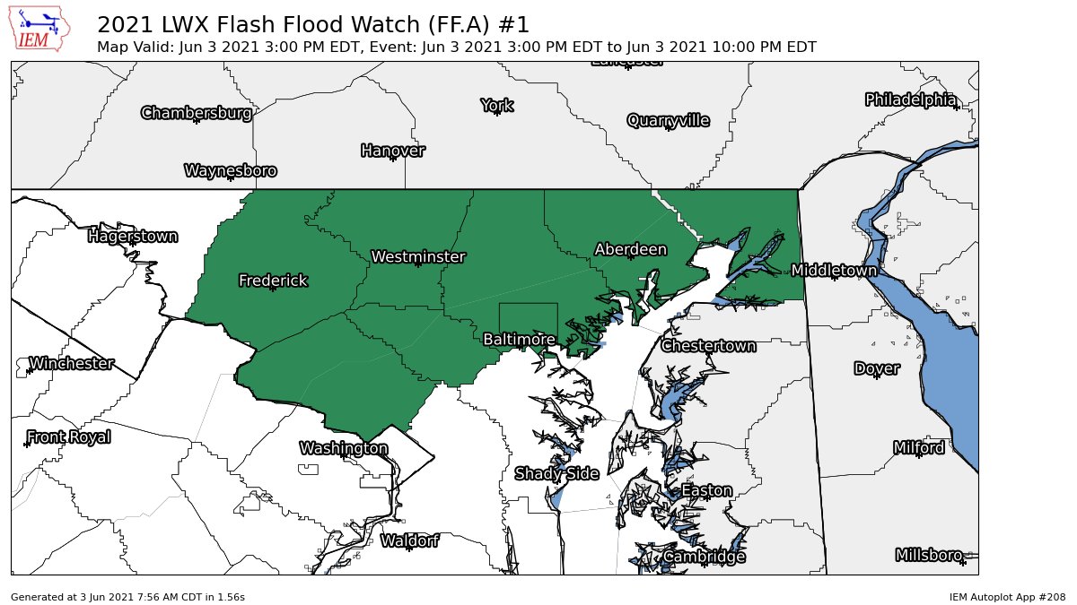
Showing posts with label Other Weather. Show all posts

Thursday, June 3, 2021

Flash Flood Watch for Parts of the DMV

Image
Good morning! The NWS has issued a flash flood watch for parts of our area including all of MoCo, Frederick County, Howard County, Carroll County, Baltimore and Baltimore County, Harford County, and Cecil County. This is from 3 PM EDT through the evening. Rainfall from numerous thunderstorms and showers will be around 1/2" across the region, but locally, where more thunderstorms develop, rainfall amounts could reach 2-4 inches. 

"Heavy rainfall in a short amount of time can result in rapid rises of water in streams, creeks, and urban areas. A Flash Flood Watch means that conditions may develop that lead to Flash Flooding. Flash Flooding is a very dangerous situation. You should monitor later forecasts and be prepared to take action should Flash Flood Warnings be issued." - NWS

I will make a post updating about the potential of severe weather later today! Until then, stay safe, and stay weather aware.

Thursday, April 15, 2021

Cicada Invasion this Year?

 Yes, you read the title right. Unfortunately, once soil temperatures reach 68 degrees 8 inches into the ground, billions of cicadas will start to emerge from the ground and invade the DMV area. We are being affected by Brood X cicadas this year.

The darker orange areas are where the cicadas will be invading in this year, 2021, while the lighter orange/brown areas are where they have invaded historically. And in DC, soil temps are already becoming very close.
This tweet from Ryan Miller says that cicadas will start to emerge soon when temps reach 64 F at a depth of 8 inches.
Then, he shows a photo of a thermometer measuring a soil temperature of 63.6 F. And it's already started in some places.
This was a photo from Springfield, VA(Fairfax County), and it shows cicadas already starting to emerge from the ground. I would be confident enough to say that in our southern areas, there are already a good amount of cicadas starting to emerge. I haven't found any reports besides this photo though.
This is what happened during the cicada invasion of 2004(it affected our area). Some started to come out in mid-April, and then when May arrived, they really started to boom, and then they started to fall after early- June.


So, when will the rest of the cicadas emerge throughout the DMV area? Well, although some of them are starting to emerge in areas, they won't really start to explode and invade until May, as stated by the Capital Weather Gang. We have a few more weeks before we really start to see them everywhere. Temps in the next 10 days will be in the 50s and that means that soil temps will cool, delaying the main arrival of cicadas. There will be some early ones coming out, but as stated before, they won't really take over until May.


Sunday, March 28, 2021

Sunday Severe Weather Nowcast

6:40 PM:

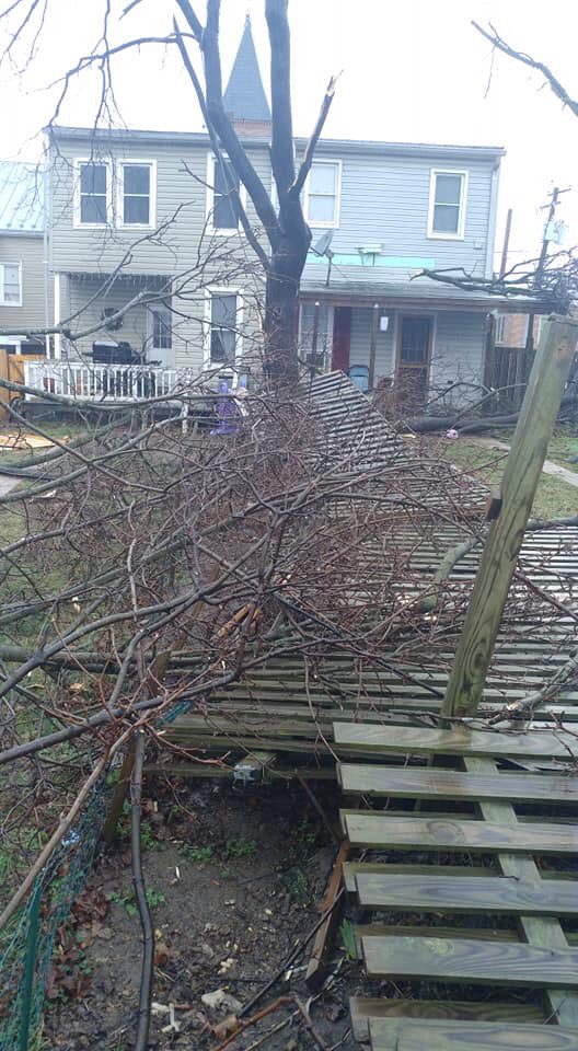
Most of the region is still under a severe thunderstorm watch until 9pm EDT. A couple of tornadoes, winds up to 70 mph, and marble-sized hail is possible. The rest of the area is in the wind advisory until 4 AM. Severe thunderstorms are expected to continue throughout the night in those pinkish areas. Staying indoors and not traveling is advised throughout the DMV.

5:07 PM:

THERE IS A SEVERE THUNDERSTORM WARNING FOR MOST OF MOCO, AND FOR A LOT OF BALTIMORE AND CAROLL COUNTY! WIND UP TO 60 MPH AND HAIL THAT IS PENNY SIZED IS POSSIBLE! GET INDOORS, GET RESOURCES, AND STAY SAFE NOW! A WARNING MEANS DANGEROUS WEATHER IS IMMINENT, AND IS OCCURING SHORTLY OR NOW!

5:05 PM:

THERE IS A SEVERE THUNDERSTORM WATCH FOR MOST OF THE REGION EXCEPT FOR OUR WESTERN REGIONS! A COUPLE OF TORNADOES ARE POSSIBLE, HAIL UP TO SMALL MARBLE SIZE, AND WIND GUSTS UP TO 70 MPH ARE POSSIBLE!! GET INSIDE NOW AND STAY SAFE! THIS IS UNTIL 9 PM EDT SUNDAY! THE SQUALL LINE HAS MOVED INTO NW MOCO AND WILL BE MOVING SOUTHEAST! GET INDOORS AND STAY SAFE NOW! 

4:55 PM:

If you are in Northern MoCo, and not in the severe thunderstorm warning, I would still advise you to stay indoors and get ready for one. Radar indicates Northern MoCo getting directly hit by the heavy precip of this squall. Even in Southern MoCo, I would advise you to be careful. Gusty winds, hail, and possibly even a tornado are possible with this line.

4:40 PM: 

TORNADO WARNING FOR EMITTSBURG AND TANEYTOWN! GET INSIDE AND SEEK SHELTER NOW! PENNY SIZED HAIL IS POSSIBLE!

4:35 PM:

THERE IS A SEVERE THUNDERSTORM WARNING FOR CLARKSBURG MARYLAND! WIND UP TO 60 MPH AND PENNY SIZED HAIL POSSIBLE! GET INDOORS NOW! THE SQUALL LINE WILL HIT NORTHERN AND WESTERN MOCO! A WARNING ALSO MAY BE ISSUED FOR AREAS MORE SOUTH OF CLARKSBURG SO BE VARY!

4:10 PM:

This squall line may reach northwestern MoCo; however it probably wouldn't be severe, and it will be brief. Precip will likely be moderate, but will quickly dissipate if it even reaches it.

3:55 PM:


SEVERE THUNDERSTORM WARNING FOR FREDERICK, BOONSBORO, AND HAGERSTOWN! WIND UP TO 60 MPH AND PENNY SIZED HAIL IS POSSIBLE. GET INDOORS NOW!

3:45 PM:

This line needs to be watched very closely. As of now, it looks like it will miss MoCo and may touch some of Frederick county, but as it gets closer, we will know if MoCo is getting hit. This squall line has up to 60 DBZ rates and may be severe.

3:00 PM:

The National Weather Service in our region has put a timeline on when to expect severe weather. Most of MoCo and our region will see severe weather around 4-6 PM, while the southeastern part of MoCo will see severe weather around 6-8 PM. The rest of our region will see severe weather around 6-8 PM, and for our far western areas, you might see it at 2-4 PM.

1:30 PM:

The SPC has put a mesoscale discussion for most of our area, including all of MoCo. It says that damaging wind gusts will happen and a tornado or two is possible this afternoon. The SPC expects 500-1000 j/kg MLCAPE to develop with "low-level moist advection of dewpoints in the 60's F." Even with cloud cover that is increasing, destabilization is expected to occur in the afternoon from VA all the way to the PA border. High resolution guidance suggests some isolated thunderstorms may form from the rain shower activity as the pre-frontal through moves eastward. Storms that develop have the potential for damaging wind gusts and maybe even a isolated, brief tornado, because of the strong low and mid-level flow across a lot of the Mid-Atlantic. A lot of doubt remains due to weak destabilization and low confidence. Another round of tstorms may develop as the cold front moves east across central VA later this afternoon, and although conditions on the surface are cooler and drier, models show hodographs that support damaging wind/gusts with linear storms "along and ahead of the front later this afternoon". And one thing that I really wanted to spot out was "Trends will be monitored for a possible weather watch this afternoon/evening". All quotes were from the SPC and this paragraph has been trying to paraphrase the SPC's words.

12:45 PM:

The SPC has updated their maps! Let's see what it shows.
The SPC has reduced the slight risk range to include almost none of Frederick county, and has also put a part of Northern Loudoun County in the "Marginal" area. All of MoCo and points south are in the slight risk, but our northwestern regions are in the marginal risk, and some of western Maryland is even in the "non-severe" thunderstorms risk! They have moved the marginal further north, into New York and even some of southern New England!
The SPC has most of our region in the 2% risk for any location to see a tornado 25 miles away from a certain point, while the southern parts of our region are in the 5% risk for any location to see a tornado 25 miles away from a certain point. Only our far northwestern regions are in the less than 2% to see a tornado.

Most of our region are in the less than 5% chance to see hail 25 miles away from a certain point, but the southern part of our region is still in the 5% chance to see hail 25 miles away from a certain point. Hail isn't the threat here.
This is why most of our region is in the slight risk; due to the damaging winds. We have a 15% chance to see 65+ mph winds 25 miles away from a certain point, and our northern regions are in the 5% chance to see 65+ mph winds 25 miles away from a certain point. The mountains are in the less than 5% risk to see damaging winds!

FROM the SPC: 

"...Mid-Atlantic into southern NY this afternoon/evening... As previously mentioned, the degree of destabilization is more in question with northward extent across VA/MD/DE toward eastern PA and NJ. Surface temperatures in the 65-70 F range will be needed to much in the way of SBCAPE and a damaging-wind threat with a forced band of convection along the cold front. Will maintain the character of the previous outlook, but the northward extent of the severe threat will depend on some cloud breaks this afternoon. The Marginal area has been expanding some into southern NY to reflect the potential for just enough low-level warming/moistening to support minimal SBCAPE and the low chance for strong/damaging gusts with a shallow convective band along the cold front."

They think that the cloud breaks in the afternoon will determine if the northern regions get severe weather, which is what I think too. They have extended the marginal risk into southern NY for the potential to support a small amount of instability and the chance for some strong/damaging wind gusts.


12:30 PM:


The second course of precip is slowly starting to fill in on the LWX radar, and will be moving into the are soon, in the next 1-2 hours. Storms will be starting to form, some severe, and 2-6 PM will be the prime time for severe storms to occur. Tornadoes are possible too.

12:15 PM:

The squall line is seeming to be missing Northern MoCo, or at least the heavy precip part of it. Even still, Southern MoCo definitely got hit.

12:00 PM:


That isolated squall line has reached the far SW part of our county! It will be moving northeast, and most everyone should see some moderate - heavy rain before it leaves quickly. There probably won't be any thunder/lightning and it will not be severe.

11:50 AM:


That line that I circled needs to be closely watched. Theres already many squall lines forming, one in western PA and one thats coming in our way. That is the front/boundary with storms forming on it, and some of them could be severe. The second course of precip is slowly moving northeast, but isnt close enough to be picked up by the LWX radar.

11:35 AM:


An isolated squall line is moving northeast, and has MoCo right in its path. This squall line contains pretty heavy precip, with 30-40 DBZ rates. It will come in fast and come out fast. Some thunder/lightning may be possible with this line. Probably not severe though.

10:30 AM:

The SPC has mentioned downgrading some of their risks for the entire region, and they have removed the signature/hatched risk for the entire area effected by severe weather. I would like to point out a mistake that I made in my previous post; I referred the wind risk by MPH, when it should have been knots. The hatched area means a 10% or more risk of wind speeds 65 knots or more(75mph+). Here are the latest SPC maps:
Slight risk for most of the region, with a marginal risk for the northern parts of our region.

A 5% risk of a tornado from any location 25 miles away from a certain point in the brown area, and for our northern area, its a 2% chance of a tornado from any location 25 miles away from a certain point in the green region.

There is a 5% chance in the green area for 1" or more in diameter hail from any location away from a certain point, and less than 5% elsewhere.

The main threat here is damaging winds, but the hatched area for more severe winds has been removed. You still need to be taking this seriously, as these are still chances for 65+ mph winds. Most of our area is in the 15% chance of 65 or more mph winds 25 miles away from a certain point in the yellow range, with our northern regions being in the 5% chance, and just south of us in the 30% chance range. The greatest threat is in the red.


Monday, April 13, 2020

TORNADO WATCH FOR MOCO AND MOST OF MARYLAND AND SOME OF VIRGINIA

2:27 PM
The thunderstorm has ended, and now it is sunny outside! At least for now...
2:10PM
The thunderstorm has arrived! The sky went from mostly cloudy to dark and cloudy in just seconds. Inside my house, my lights are flickering. There was thunder, and you better believe it was loud! There was also lightning, but mainly thunder. There was thunder before the rain. Torrential downpours are falling outside my house, and I can hear the winds howling as they gust.
2:01 PM
The severe thunderstorm warning has been extended to 2:45 PM.
1:28 PM
There is a severe thunderstorm warning for 55% of MoCo(the northern half) that includes Gaithersburg, Clarksburg, Damascus, and Olney. Most of Fredrick County, some parts of Loudoun County, and Caroll county are in the warning as well. It ends at 2:00 PM. There is also an Areal Flood Warning for NW Washington and Southern and Central MoCo. The tornado watch and wind advisory are still here.

11:43 AM
There is a tornado watch for most of Maryland, including MoCo and D.C., and parts of Virginia(eastern VA). Those watches may turn into warnings. There is sleet like hail and torrential downpours outside my house(including minor flooding). 

Sunday, April 12, 2020

Severe Weather Sunday Night- Monday

There is severe weather likely for parts of the Southeast, and that includes the DMV. There is a wind advisory for MoCo, and other parts of Maryland, including most of Virginia, and everyone else(except for D.C, who is in a wind advisory) is in a high wind warning. Tonight and tomorrow, there will be thunderstorms and rain, severe possible, with lots of winds, some damaging. There could also be hail and even tornadoes. However, the main concern for tornadoes is far south, but it could still happen here. There could even be flooding. It says this all in the hazardous weather outlook(note: this is for the NWS station for DC/Baltimore):  "A Wind Advisory is in effect for much of the area beginning at 4 AM EDT tonight. Showers and isolated thunderstorms are expected late tonight. Heavier showers and thunderstorms may contain locally damaging wind gusts after midnight. There is also a threat for localized flooding after midnight. A High Wind Warning is in effect for the Appalachians and Blue Ridge Mountains and adjacent areas from 6 AM to 6 PM Monday. A Wind Advisory is in effect elsewhere until 6 PM EDT Monday. Severe thunderstorms are possible Monday, especially during the mid-morning and afternoon hours. Damaging winds, large hail, and an increased threat for tornadoes exists. Localized flooding is also possible on Monday."

This outlook says it all. There could be power outages and downed trees, especially in areas who are under a high wind warning. Since everyone is staying home, the best advice I can give you is to be prepared for severe weather and be ready in the event of a tornado warning. You can do that by turning on your emergency alerts, check the radio/news, etc., and in case of a tornado, go down to your basement(your lowest floor) and/or go to a room with no windows(or the least amount in your house).

Weather Risks Mon-Sat. Index on the far left. 


Wednesday, February 26, 2020

Weather Update

There is a pretty good chance of thunderstorms and showers tonight, specifically between 9:30AM Wednesday-1AM Thursday. There is a chance of tornadoes, but it is pretty low. It could happen though, you never know, but it seems unlikely. We could get a severe thunderstorm, but again, there is a low-medium chance of that happening(has a better chance of happening than a tornado though)(35-51% chance). There will be a strong thunderstorm, potentially a severe thunderstorm(best chances to the west of MoCo)(strongest thunderstorms may be west of MoCo).  After today, it will get much colder and windier through Thursday(cold front moving in which gives us cold winds). The cold front is supposed to last from 2/27/2020-3/2/2020.  3/05/2020-3/11/2020 is supposed to have normal(average temperatures). Cherry blossoms are already in the process of blooming in many places and have bloomed already in some places in the DMV(mainly D.C. and south)! They are in the process of blooming(starting to come out of their buds) in my yard, in Gaithersburg!


But where is the winter? So far, I have ONLY recorded 4.8 inches of snow in Gaithersburg, but most reports show people getting around 3" of snow, with a lot of places getting below that. Some places are getting more than that, but those places are north and west(Fredrick County, Loudoun County, Shenandoah Valley, Blue Ridge, Mountains, Garrett County, Allegany County, Washington County, etc.). The reason for the lack of snow is not the lack of precipitation; in fact, it is the exact opposite. We are having lots of precipitation(rain), but what we are lacking cold air. The Polar Vortex is locked up in the north(Canada, Alaska) and is not collapsing(giving the lower 48 cold air). So far, there is 0.6" of snow in Reagan National(its been a year since an inch or more of snow there), 2.9" of snow in IAD(Dulles), and 1.8" of snow in BWI(Baltimore)(if it doesn't snow this February, this will be the first time there will be a snowless February in Baltimore). These snow totals are way, way, way below average for this moment in time, let alone seasonal. If we want above-average snow, we need a major snowstorm in March(10-12"+). We need at least 52" of snow if Reagan National wants to keep it's average the same(15.4" of snow). This is a very long shot from happening, let alone getting above-average snowfall this year. This cold front could be our last chance for getting snow before spring comes(it is basically already here). I am not saying it is our last chance for snow this year, but I am counting on this to give us a good snowstorm.

Friday, February 7, 2020

Snow Showers and Tornado Warnings In The Same Day?!!??!

Today, was truly, a remarkable day. I don't think that this has ever happened before, even before I was born in this area. There was a tornado today, along with snow showers today, IN FEBRUARY. There were reports of tornadoes in Poolesville/Dickerson, Westminster, Southern Fredrick County, and Leesburg(Confirmed EF-0 tornado in Leesburg, VA). The damage done was a lot. A wind advisory with gusts 50-60 mph+ today, plus with a severe thunderstorm before 9AM. We didn't get tons of rain, instead, we got... something way better. This will go down in weather history. And to top it all off, there were snow showers tonight, in Damascus and GBurg(probably more places in MoCo as well). Snow in the mountains, blizzard conditions in New England, a bomb cyclone: this storm was definitely remarkable. Today will go down in weather history. All I have to say is... Maryland weather is weird. Update: Snow is becoming much heavier. There is a confirmed EF-1 tornado in Cecil County, MD.
Image
Westminster, MD Tornado Damage(credit: Joseph Bowers)


Flurries after a tornado warning in Damascus, MD. (Credit: Ryan Douglas).
Image


Tornado Damage in Leesburg(credit: Joe Spevak)


Image

Maryland Weather Meme(credit: Martin Amini)


THERE IS A TORNADO WARNING FOR CLARKSBURG!!

THERE IS A TORNADO WARNING FOR CLARKSBURG AND OTHER NORTHERN PARTS OF MOCO!!!! GET SHELTER IMMEDIATELY!!! THIS LASTS UNTIL 8:15 AM!!! THE TORNADO IS VERY CLOSE TO GAITHERSBURG, UPPER MOCO TAKE SHELTER!! THERE IS A WIND ADVISORY FOR ALL OF MOCO AND MD AND A WIND WARNING FOR CITIES NEAR THE OCEAN/DELAWARE!


"As this area of showers moves through the region, a brief period of
extremely heavy rainfall, small hail, and gusty winds of 30 to 40
mph are likely. A couple storms could have severe wind gusts over 60
mph. If driving, you should be prepared for a sudden sharp drop in visibility and slippery roads. The heaviest showers and storms
should move through the immediate DC and Baltimore areas within the next hour, with lighter rain expected after 830 AM."-NWS


THE WIND ADVISORY LASTS UNTIL 3PM!!! THERE IS ALSO A SEVERE THUNDERSTORM WARNING FOR DAMASCUS AND CLARKSBURG(THE UPPER PART OF MOCO)!!!


Saturday, January 4, 2020

Winter Forecasts for the 2019-2020 Winter!(snowfall)(FIRST POST OF 2020!)

Yes, this is the moment you have been waiting for, the WINTER FORECASTS FOR 2019-2020! In my opinion, these forecasts predict good snow for this year(average to above average), but others predict below average.

Here is FOX 5's forecast:               
Fox 5 predicts 25-35 inches for the upper 1/3 of the county and 15-25 inches for the other 2/3 of the county. The more north you live in the county, the more snow you will get(I would say we are in the 20-30 inches range).
 
   
Here is NBC 4's winter forecast for this year:
  NBC 4's forecast is a jackpot for snow. Southern MoCo will get 18-26"(amounts to the higher end) and Middle and Northern MoCo will get 28-37"(that is a lot!). According to Doug Kammerer, he is going for about 50% more snowfall than average. "I think we’re going to see a couple of pretty good storms, meaning 6 to 10" snowstorms or 6 to 12" snowstorms," said Doug.
Here is WUSA 9's forecast:
 WUSA 9 expects a La Nada winter this season. This means that there could be a lot of snow, or very little snow. They are saying that cities that are in the beltway(basically the southern half of MoCo) will receive below-average snow, but since we are on the edges, I will say that the Southern half of MoCo gets 1-3 inches below average, probably less than that. This winter map is predicting is average to above-average snowfall this year(about). The other half of MoCo should be getting above-average snow. We are in the 10-30" range(15-30 is better estimated for the whole county).

Here is ABC 7's forecast:
This shows awfully below-average snow for our county. 7-22 inches?! We get can 7 inches and more in 1 snowstorm, this is the forecast that is the least optimistic. Most of MoCo is in the 12-22" area, while the other part of MoCo is in the 7-17" area. This forecast is extremely below average, but not as bad as the 2017 and 2018 winter.

The Capital Weather Gang's Forecast:

According to Capital Weather Gang, the 2nd half of winter(very late January to end of winter)(late March) will be harsh(lots of snow and cold temps) after a gentle start(non-significant snow events)(4">)(normal temps). That means the whole month of February(and early March) will be the prime time for snowstorms. Anyways, 55% of MoCo is in the 14-24" range(places 1000'< have a higher chance of getting 24"+) and the other northern 45% is in the 22-34" area(areas 1000'< will most likely have 34"+ of snow). Montgomery County(specifically) will get 15-25" of snow. This map shows around average to slightly below average snowfall. Now, let's look at the average of these maps!


Fox 5: 15-35" of snow.

NBC 4: 18-37" of snow.

WUSA 9: 19-30" of snow. 

ABC 7: 7-22" of snow.

Capital Weather Gang: 15-25" of snow.

AND THE AVERAGE OF THESE MAPS ARE... 14.8 inches- 29.8 inches of snow! Is this below average snow for MoCo. Above-average? The average amount of snow(for MoCo) is 16-27" of snow(Bethesda-Damascus)! So, the 2020 winter will have an average of 22.3" this year(snow amount most people will get). The average amount of snow is 21.5"(for the county as a whole)! So, the 2020 winter will have(according to these maps) will have above average snowfall(0.8" more!)!! WE WILL HAVE ABOVE AVERAGE SNOWFALL! This is good if you are a snow lover and/or you want more snow days(and delays). NBC 4 has the most optimistic map for snowfall, while ABC 7 is the least optimistic map for snowfall. Overall, we will get(according to my predictions)(based on the maps) 3-7 snow days this year(we already had one)! Delays won't be predicted because delays depend on how much small snow events there are(Alberta clippers) and freezing rain(melts before 10:45 AM). There is no predictions for freezing rain, so it is way harder to predict. If I had to take a wild guess, I would say 5-13 delays this year, though I am pretty sure I will be wrong. We also have subzero temperatures and wind chills to deal with, so it makes it even harder for me to predict. This winter should be good, so stay tuned to my posts! Thanks for reading!

Friday, July 19, 2019

Heat Wave for the DMV

Heat warnings and advisories throughout the region(updated). Source: National Weather Service
As you might have felt outside, it feels very hot. That is because of the heat wave we are having this week. There is an Excessive Heat Warning in effect for most of Maryland(including MoCo) and some part of Virginia. The Heat Warning is expected to last until 9PM on Friday. Heat index(how it feels outside) will be 105-115 degrees depending where you live. Then on Saturday and Sunday, there will be a heat watch that will probably be updated to a warning on Saturday and Sunday. Saturday is expected to be the worst day of this heat wave. Make sure to try to stay inside your house at all times possible, and when you have to go outside, be prepared(stay in shade)(wear hats)(use sunscreen) and don't stay outside for too long. Also, make sure to stay hydrated and drink lots of water, and don't ONLY when you are thirsty, drink even when you aren't thirsty.
Heat indexes(yellow colored) compared to actual temperatures(white colored). Source: WUSA9
Heat Watches and Warnings throughout the DMV. Source: WUSA9
Sunday will be the coldest day of the heat wave, and there is a chance for some rain and some thunderstorms.
Temperatures and heat indexes through Friday to Sunday night. Source: National Weather Source
But I have some good news. After Sunday, the weather will become a LOT colder, with lots of rain on Monday. After Monday, the weather should be fine.Take these heat warnings and watches seriously, because high temperatures are very dangerous, and it's not very often we get heat waves this hot.

Tuesday, March 19, 2019

Spring Snow Possibility and Other Weather News

There is a snow threat next week(spring snow?). Some models show a system that could bring MoCo some snow. The German model(ICON) gives us the most snow for this system(out of all the models). It shows some areas in MoCo getting up to 6 inches of snow. It doesn't mean MoCo is the "jackpot" for this storm(in the ICON snow depth map). The "jackpot" area of this snowstorm is far out west.Remember that this is over five days away, so take model snow amounts with a grain of salt. It has to be below freezing for the snow to stick, and because it's almost April, snowfall rates have to be heavy, and roads and sidewalks in some places in the county may not need any winter preparations at all. Also, just so you know, 3+ inch snow events in D.C after Mar 20 are rare.


 Spring:

March 19, 2019, is the last full day of winter. When you wake up on March 20, 2019, it will technically still be winter. Spring, in the Northern Hemisphere, will start at 5:58 PM. If you are reading the edited version, it's already spring.The D.C cherry blossoms are supposed to bloom somewhere between April 1-6. Some of the cherry blossoms have already bloomed in D.C, for example, in the Washington Monument. I expect the cherry blossoms to bloom around April 2-4.


Winter 2019-2020:

According to the NWS, weak El Nino conditions are expected to last throughout spring(80% chance) and throughout summer(60% chance). What is El Nino though? According to NOAA, "The term El NiƱo refers to the large-scale ocean-atmosphere climate interaction linked to a periodic warming in sea surface temperatures across the central and east-central Equatorial Pacific." UPDATE: The Bureau of Meteorology, Austraila says there's a 70% chance that there will be an El Nino next year, raising the watch to an alert. Verified ac   
El Ninos can give the Mid-Atlantic above average snow, depending on the El Nino strength. A moderate El Nino gives us the best chance for above average snow. The moderate El Nino in 2009-2010 gave D.C its most snowfall ever in a year. It gave D.C(DCA) 56.1 inches of snow that year! That is 40.1 more inches of snow than the average snowfall amount(15.4 inches)! But, why does this matter?  The hype is that this will become a moderate El Nino in November. If this happens, then it will be a 2009-2010 winter again.

Featured Post

Archival of Blogger and Move To Substack

Hello everyone, I'm making this post as a formal gesture that I have fully moved to Substack and will not be using this website anymore....