Showing posts with label Crazy/Very Unusual Weather. Show all posts

Friday, April 30, 2021

Wind Storm Update + Nowcast

5:55 PM:

This area of precip is about to hit MoCo. You may see some downpours, and probably some really gusty winds. It will have to be closely watched. I see up to 50 DBZ in this area, but you will start out with low rate precip.


5:30 PM:


This area of precipitation moving (south)east needs to be watched carefully. Winds could be enough to deem this severe. It isn't a small amount of precip either. Radar is still filling in with precip(LWX radar). This area of precip could hit MoCo and DC. 


5 PM:


The severe thunderstorm warning for Germantown will be allowed to expire at 5 PM. However, the thunderstorm warning continues for Southern MoCo. Penny sized hail and 70 MPH winds possible.


4:50 PM:


SEVERE THUNDERSTORM WARNING FOR ALL OF MOCO! 60 MPH WIND EXPECTED AND PENNY SIZE HAIL POSSIBLE! GET INSIDE, STAY AWAY FROM WINDOWS, AND SEEK SHELTER NOW! THIS IS A LIFE THREATENING EMERGENCY!!


4:25 PM:


These are the peak winds recorded so far. The winner is Petersburg, with a gust of 62 MPH. You can see most of the region has at least 40 MPH winds and theres a good amount who saw over 50 MPH winds. These numbers may increase.


4:10 PM:


At this point of time, we are in the height of the storm, in peak wind(wind will be sustained throughout the evening). So much damage reports are coming in, including fires caused by downed power lines. Around 3000 people are without power in MD, with more to come as the night goes on. Some roads will be blocked. Lots of wind reports at 50-60 MPH. 
This line of showers may contain pea size hail(0.25" hail) and 50-55 MPH winds. This will make the situation worse. It's right now hitting Washington County and Winchester, and may hit Frederick County, Loudoun County, and MoCo. Lots of reports of pea size hail with this line of showers.


2:30 PM:

Throughout the region right now, widespread wind gusts of 45-60 MPH are being observed. Isolated wind gusts that are higher than right now are possible through the evening, and a wind gust of around 70 MPH cannot be ruled out in Northern Maryland's higher elevations. Scattered shower activity will peak this evening, and thunder + small hail are plausible and can't be ruled out because of cold mid levels.  Lows in the 40s with wind chills in the 20s are expected tonight.
- Paraphrased from Forecasters Discussion

1:50 PM:


These are the latest recorded wind gusts. As you can see, the highest gust so far is 58 MPH in Cumberland. In MoCo, 48-50 MPH gusts are being recorded. We are approaching peak wind time, which should be around 3-5 PM. Winds are starting to really pick up everywhere, and sustained winds are also rising too. A lot of downed tree reports came in at the same time, and with sustained winds plus wind gusts, trees and power lines will become weak and even fall. Already some pretty good wind damage here. Lots of tree logs(>3") have fallen and been blown away.


12:25 PM:


In the past hour or so, the wind reports have been exploding like crazy. Someone has also died from this event. A tree fell on their vehicle. Many reports of downed power lines and fallen trees. In MoCo, a tree fell and caused an accident with 3 injuries(I-495/Beltway Outer Loop After I-270). It's getting really bad out there. And the worst part? We aren't even at peak winds yet. In the next hour or two, we will reach peak winds. The max wind gust reported in Maryland was 54 MPH in Thurmont. The highest recorded so far in the DMV is 57 MPH in Kline Gap, WV. Outages are rising. Around 2300 in Maryland and 230 in MoCo. Please stay safe everybody!


10:10 AM:

Already some tree damage occuring. Lots of twigs and logs have been broken and fell on the ground.


9:50 AM:


The high wind warning has been extended to include all of MoCo, Loudoun County, DC, PG county, and the Shenandoah Mountains. 25 - 35 MPH sustained winds are expected with gusts up to 60 MPH. There is high confidence of a stronger wind field and long duration of wind. The warning is until 2 AM Saturday EDT. The strong winds will result in widespread tree damage and power outages. And, some reports are already coming in. We aren't seeing peak winds yet, too!

As you can see, there are multiple wind reports across the DMV. In NE Fairfax County, there is a report of downed wires. In SW Cecil County, there is a report of a tree fallen onto the ground. These reports are going to start to explode as winds pick up.

Thursday, April 29, 2021

High Wind Watch Upgrade and Advisories

 The high wind watch got upgraded to a warning for our northern areas, and almost all of the DMV(other than northern areas) are in a wind advisory. Let me show you the map.

Areas in the light blue/cyan are in a freeze watch(not our area). Areas in the light brown are in the wind advisory(includes DC, Southern MoCo). Areas in the orangish-brown are in a high wind warning. In the high wind warning, you can expect northwest winds sustained at 20-35 mph with gusts up to 60 mph. In the wind advisory, expect northwest winds sustained at 20-30 mph with gusts up to 55 mph. For areas in the high wind warning, widespread power outages are expected, winds will blow down trees and power lines, and travel will be made much more difficult for high profile vehicles. If you are near the high wind warning(less than 2 miles away), I would recommend preparing for the same impacts as areas in the high wind warning. You may even see winds that of those of the high wind warning. In the wind advisory, isolated power outages may occur, and tree limbs + unsecured objects may be blown around. No matter where you are, it will be bad regardless. 

What about school? The whole county isn't under a high wind warning but the northern part is, and if one part of the county closes, the other has too. Will we see in-person people going virtual, or even no virtual instruction? That depends on how much power outages there are, and if the winds will be strong enough to cause widespread power outages. The last time school closed for high wind was in March 2nd, 2018, where wind gusted up to 80 mph in some areas(up to 70 mph was expected)! At it's peak, over 500k people in our area did not have power! It was quite crazy. We had sustained winds of 20-30 mph winds that day, and similar sustained winds are expected, with slightly more potential. I am not sure if there will be strong enough winds to recreate that large of an impact. However, trees and power lines have already taken quite a beating this year from other storms, from severe storms to winter weather storms, with ice and snow pilling on the trees and wearing them down. We have also had many wind advisories this year, as an addition. A lot of my trees in my neighborhood have had to been cut or have been visibly worn down. I think there is a 50% chance for in person to be canceled and everyone to go all virtual. However, the chance for no virtual instruction is lower. I would place it at around 45% right now, but it would be 45-50% if I could choose a range(I will play it conservative for now). The 2018 event had high wind warnings for the entire region, and it was expected to be worse, with stronger winds. It's gonna be hard to choose. The wind event now is expected to come in 2 waves: one Friday afternoon, one Friday evening. They will be the strongest at this time. This will make dismissal difficult for in person students. I'm not really sure. I think if there is enough power outages there could be no virtual or in person, but it's too difficult. It's really just 50/50 for both options.

TL;DR I think there is a 50% chance for in person to be canceled and for all virtual, and a 45-50% chance for no instruction at all. Read above for the exact explaining. 

*Edited by QuackyDucc

Saturday, April 24, 2021

Late-April Snow in the DMV??

 Yes, you read the title right, snow fell in late April this year for parts of the DMV. And, its not just western and northern Maryland. There were reports of snow around DC(Arlington) and Baltimore + DC Metro. Some reports of snow possibly even in Baltimore City! It happened the night of April 21(as the cold front pushed through) and throughout April 22. In MoCo, here, I was able to record snow as well. And I was able to see it fall too. Last year, I saw snow in May, but this is also pretty rare. On the same days, frost advisories and freeze warnings impacted the region. On April 21, Baltimore got close to breaking its low record of 32F. Although I couldn't find reports, radar showed snow showers hitting MoCo and surrounding areas multiple times, and that probably means that there was snow in MoCo apart from just me.

This was my video of snow falling. If you look closely, you can see a small part of snow falling. I can confirm this. It didn't melt the instant it reached the ground, and stayed for a couple seconds before eventually melting. Pretty crazy day! We usually dont get snow this deep into April. Winter should pretty much be over after this weekend for a lot of the eastern US. You might have noticed there aren't much blog posts coming out, and that's because there really isn't much going on in the DMV weather world right now. May and June will probably be more interesting because of severe weather, but we will have to wait and see. Until then, enjoy the nice weather, and I'll see you in the next blog post! Oh, and a winter recap is coming around May.


Wednesday, April 7, 2021

April Fools Storm Recap

In the morning, there were reports of mixed rain and snow for the northern part of the region and possibly some stickage in northern Frederick and Caroll counties. Throughout the day, north winds and bands from PA brought graupel, sleet, and mixed rain and snow throughout a lot of the region. Then, after 3 PM, bands were forming that had less mixing in them and more snow. Then, at 4-5 PM, a band formed that mostly pure snow and brought heavy precip rates for a lot of the part of our region! Snow was reported as far into parts of Southern Maryland! Thundersnow/graupel was reported, which is really rare(0.07% chance in snowstorms), and especially cause it is in April! Stickage was reported in some parts of our northern region, and I was able to get a dusting/coating of snow, which is often recorded as 1"! Some people saw snow in temps as warm as 45-50+! It dropped from 44-42 in less than 5-10 minutes to 39 for me! Visibility dropped to <0.50 miles! That shows you the power of dynamic cooling and north winds! Bands were still forming in PA and coming SE to hit the DMV region as the sun starts to set and temps drop. There were also a lot of gusty winds. As the night continued, bands started to hit regions and some people woke up to a coating of snow on their cars and surfaces as temps drop. This was a pretty unique storm to say the least.

Saturday, February 13, 2021

Ice Storm Warning for MoCo

 There is an ice storm warning in effect for the whole county. This has not happened since February 12, 2008; which is over 13 years! From NWS:

 "...ICE STORM WARNING IN EFFECT UNTIL 7 AM EST SUNDAY...

* WHAT...Two to three-tenths of an inch of sleet and freezing rain causing significant icing impacts. 

* WHERE...The District of Columbia, and portions of central Maryland and northern Virginia.

* WHEN...Until 7 AM EST Sunday.

* IMPACTS...Difficult travel conditions.

* ADDITIONAL DETAILS...Roadways are becoming very icy and dangerous. Avoid all unnecessary travel.

PRECAUTIONARY/PREPAREDNESS ACTIONS...

Travel is strongly discouraged. If you must travel, keep an extra

flashlight, food and water in your vehicle in case of an

emergency. Prepare for possible power outages.

When venturing outside, watch your first few steps taken on

steps, sidewalks, and driveways, which could be icy and slippery,

increasing your risk of a fall and injury."

I can already report a tenth of an inch of ice here in Gaithersburg and a lot of sleet on the ground(over a tenth of an inch of sleet). Pre-treatments are useless, and I can clearly see a coating of sleet on top of the freezing rain. Tree branches are facing down and look like they will snap. It's really coming down here. Every single surface, even treated ones are covered in lots of ice and sleet. Do not travel at all. Power outages are possible, and tree damage will be done. This will be extremely dangerous. There are already so many accidents and injuries on the roads now. Stay safe inside and prepare for an extended period of time without power. Here are some links to help you: What To Do When Lose Power During An Ice StormPower Outage Checker(click on your state name), and the National Weather Service for the latest updates on winter weather.

Thursday, February 11, 2021

Saturday Storm Update and Some Other Storm News

 Well, snow lovers love a good snowstorm. Others hate it. But, the type of storm coming up on Saturday is something both snow lovers and snow haters hate: an ice storm. Sure, a little bit of freezing rain that causes a glaze on surfaces is pretty, and not much is done. But once you get over a quarter inch, that's where instead of looking pretty, it becomes devastating and catastrophic, with injuries and even sometimes fatalities occurring. We have 3 storm threats in the next week or so. The first one is on Saturday. The second one is on Monday to Tuesday(may linger onto Wednesday) and the third one is on Friday to Saturday. Thankfully(I say that because it's ice, not snow), this storm does seems to have less moisture than the next 2 ones. However, as it stands, the next two ones look like ice storms too. And just to show you how active this pattern is, let me show you something.


Well, there's something you don't see everyday! Winter storm threats for the northern regions for the entire time period the NWS' "Winter Storm Threat" covers! I have literally never seen this before. This is insane! There is an enhanced threat for the entire region I forecast for, on Saturday(high confidence, "low" impact). A lot can change though. Besides the crazy pattern that can easily be compared to the historical, record-breaking(in terms of snowfall) winter of 2009-2010, let's focus on our first threat: Saturday. Watches have been issued JUST south of us for Saturday's threat. I assume they will be extended northwest soon enough. You know it's a little bit wacky when D.C is the most northern zone in a watch; or any alert for that matter!

European Model:


The European model shows moderate-heavy freezing rain falling the whole time this storm, with rain far south of our county and snow far north of the county. It doesn't show any sleet either. It shows the system starting on Saturday evening/night and shows it getting out of here by Sunday.


Now, the European model has been very bullish with the ice, showing over a HALF inch for the entire county(image courtesy of Justin Weather) Once there is over a half-inch of ice, widespread power outages occur, and severe tree and power line damage is done. Not to mention travel is literally impossible. Although this is a lot, even half of this would cause major issues. The European does not seem to be backing off. Temps will be much below freezing on the ground the entire time, so any ice should accumulate.

GFS:

The GFS mainly shows scattered freezing rain showers instead of an ice storm. It shows them lasting from late Saturday night and shows them stopping after very early Monday morning(1-3 AM Monday).


The GFS shows much less ice than the European model, with only 0.05 to 0.15 inches of ice(Phew!). This will still cause disruptions though.

CMC:


The CMC shows the storm starting as an icy mix(sleet and freezing rain) before turning over to heavy freezing rain and then eventually going off to the ocean. More sleet would lessen the impacts of this storm, as sleet is less disruptive than freezing rain.

The CMC shows 0.3 inches - 0.5 inches of total accumulated precipitation. If most of this is ice, we could have a pretty disruptive problem on our hands.


Temps on the ground will be below freezing the entire time. Plus with the snowpack we have right now, ice will accumulate on any untreated surface, and will wash away pre-treatments if not put out regularly. This freezing rain shouldn't melt completely once the storm is done, it should be staying here for a while.  I won't be showing the other storms until this storm is done. Why? This storm will set up the next storm from Tuesday to Wednesday. And the Tuesday to Wednesday storm WILL set up the next Friday - Saturday storm. And besides, we are very far out. I don't think it's a good time to talk about them, because they will be changing rapidly. They could be major winter storms for us(the storms next week). They should be either snow or ice due to an arctic high and cold air in place. The latest storm(this Saturday) does seem to be trending towards being weaker, which is good. After the next 2 weeks, winter does seem to be weakening its grip a bit(we could still see some good snow after the next 2 weeks). Travel will be very dicey and difficult; impossible at times on Saturday evening - Sunday. Please avoid any unneeded travel unless absolutely necessary, and make sure to stay slow and careful on the roads; don't make any sudden movements or breaking. What appears to be wet surfaces is most likely ice. I will release another call tomorrow and my final call on Saturday.


Thursday, December 24, 2020

White Christmas Update

So, nothing has really changed for the white Christmas possibility. We won't see over an inch of snow(unless you live far north and west or in the mountains), so we won't have an official white Christmas. However, today is going to be crazy in terms of weather. Right now, in the morning, there are just mild showers(rain showers). As the day keeps going, the rain becomes heavier, and we will start to see thunderstorms, some even severe. We will start to see downpours, that could possibly lead to flash flooding. We could even see some tornadoes in areas. However,  the most likely, and most concerning issue, will be damaging winds(40mph+ possible) and flooding. Our area is under a flash flood watch, which means we could see some dangerous flooding. When we go through the night hours, the severe, rainy weather will start to wrap up as temperatures start to drastically drop. And that folks, is our chance to see some snow. The more west and north you are, the more snow you will see, because of that cold front pushing through faster. And herein lies another big concern: Black Ice. It will have rained a lot by the time temps start to become colder, and there will be enough water on everything that there will be a flash freeze. What about the snow? Snow will easily start to stick as the temps drop. There won't be much snow, as I said before, in terms of accumulations. Some areas in our county may see a coating/dusting, but that's about it. The snow may continue into the morning hours of Christmas, but will most likely wrap up by the afternoon. For the week or so, it's going to be very cold. These are below-average temperatures for December and will feel even colder because we have felt a lot of above-average winter temps in the past 4-6 years(more than average or below average). The only danger I would say for Christmas would be the black ice, other than that I think it will be fine, at least weather-wise. Merry Christmas!

Wednesday, December 16, 2020

Snow Reports and Backend Snow

UPDATE: The backend snow is starting to push in as temps start to drop.  Our surface low is pulling away, which means that we should be cold enough to support snow/sleet. Read down below for more info.

What Happened in This Storm

This snowstorm started around 9 AM then the snow rate really started to pick up and become heavy at around 10:30 AM and lasted until 12:00-3:00 before the snow turned into a mix. It's now a mix for almost all of the county. So before the mix started, I measured about 4 inches of snow in Gaithersburg, and I have heard a range from 1-3+ inches of snow in MoCo. There is now freezing rain outside my window, and if it's raining but is below 32 degrees, that means that it is freezing rain. When I went outside, the conditions were so bad. There was a mess of ice, snow, and slush everywhere on the roads, even though snowplows and other help came in my neighborhood over 6 times. The plows got stuck at one point, but it was snowing so hard that the help eventually became useless(0.5+ inches of snow per hour) The ground is super slippery and dangerous, and objects that were outside were very slippery. Ice has become a huge concern now, and even after a lot of us switch to rain, a lot of us will switch back to a mix/snow, and temps will drop below 32 for EVERYONE, causing a massive and dangerous refreeze. Please do not travel unless it's necessary. If this was a normal day, a lot of buildings would be shut down. There is also a flood watch in effect for southern MoCo, as everything melting plus with rain will cause major issues with flooding. I have never seen this before in a winter storm. Temps are hovering around freezing as well, so it's very messy.


Backend Snow: 

Models are showing some backend winter precip, for Wednesday night and early Thursday AM, which is good for snow lovers like me, because snow will accumulate faster, due to low temps and no to little sun angle(it's night what do you expect?). If what they show happens, and the rain/snow line moves east/south, we could get 1-4 extra inches of snow, however, the models are showing more sleet than snow. We will see. The rain/snow line, according to the models, will more likely move east than south, which is still good.


Monday, December 14, 2020

Wednesday-Thursday Snowstorm Update

The winter storm watch has been extended for all of MoCo, and I expect warnings will be issued soon. Everything, for the most part has held up, in terms of snow totals that is. There were reports of wet snow in a lot of areas in this county, but it was nothing significant. Let's just jump straight in!

Models:


This is the American model. It has changed... somewhat. It shows less snowfall but still shows our area getting about 3.5-8 inches of snow, same trend(more north and west more snow).


This model is the European model, and it has been standing pretty still. This is also the most historically correct model. It shows MoCo getting 6-9+ inches of snow.

At this point, the models aren't that useful anymore(they still are), because the weather forecasts start to lock in. The models have pretty much already locked onto a winter storm, and a significant one at that too.

Fox 5:


Fox 5 shows 3-6 inches for 3/4 of the county, and 6-12 inches for the upper quarter of the county. That I-95 corridor really determines whether you will see lots of snow or not that much. North and west of I-95 will see more snow, while south and east of I-95 will see less. The main amount of snowfall will fall during Wednesday night and early AM hours of Thursday. Mike Thomas(Fox 5 meteorologist) didn't want to change their forecast from earlier today since it held up pretty good.

NBC 4:

NBC 4 shows 4-8 inches for most of the county, and 1-4 inches for the southern part of the county. Also, it's very difficult to see, but a very small portion of extreme northwestern MoCo will see 8-12+ inches of snow. MoCo is really the snow gradient in this storm, meaning that what you will see in Damascus will be much different than what you see from Silver Spring. A mile difference and you could see a massive change in conditions. I agree with this one a lot.

ABC 7:
Similar to NBC 4's map, most of MoCo will see 4-8 inches of snow, while southern MoCo(1/4 of county) will see 1-4 inches of snow. This one is very similar to NBC 4's map so I won't spend any more time on this.


The National Weather Service:


This map is a mess, and just really shows how much MoCo is the battle zone between rain and snow. Southern MoCo will see 4-6 inches of snow, mid-county and lower upcounty(Gaithersburg, lower Germantown, Olney, etc.) will see 6-8 inches of snow, upcounty will see 8-12" of snow, and Damascus(northern side of upcounty) will see 12-18 inches of snow. Some people in upper Maryland, between PA's border, could see... up to 2 feet? That's quite a lot. If the battle area moved down just 10-25 miles, a lot of us would be seeing more than a foot, maybe even 2 feet! Basically, anyone north or west of I-95 has a really good chance at seeing 6+ inches of snow.


This has not occurred since 2016, 5 years ago, during the monster blizzard! This will probably be the most snow we have seen since 2019, or maybe 2016! Places above I-95 are in the high threat area, which means this(in their own words): "
High threat of high impact winter storm. Potential impacts include significant travel delays, closures, and threats to life and property.  Plan ahead to minimize impact on you and your family."
Places below I-95 are in the enhanced threat, which is still quite significant. This threat has become really significant, and borderline severe! Now do I expect totals to be like the 2016 blizzard? No, I doubt it. Quite a lot actually. But we could easily receive over a foot.

According to the NWS, the chances of us receiving over 4 inches is pretty high, about 50-90%+!


Here are the winter storm watches:

Upcounty:
...WINTER STORM WATCH REMAINS IN EFFECT FROM WEDNESDAY MORNING
THROUGH LATE WEDNESDAY NIGHT...

* WHAT...Heavy snow possible. Total snow accumulations greater
  than 8 inches possible.

* WHERE...Portions of central, north central, northern and
  western Maryland, central, northern, northwest and western
  Virginia and eastern and panhandle West Virginia.

* WHEN...From Wednesday morning through late Wednesday night. Snow
  will most likely overspread the area later Wednesday morning
  into Wednesday afternoon. The heaviest snow is most likely late
  Wednesday afternoon through Wednesday evening.

* IMPACTS...Travel could be very difficult. Potential impacts
  include significant travel delays and closures. Plan ahead to
  minimize impact on you and your family.

PRECAUTIONARY/PREPAREDNESS ACTIONS...

Monitor the latest forecasts for updates on this situation.


Down-County:

...WINTER STORM WATCH IN EFFECT FROM WEDNESDAY MORNING THROUGH LATE WEDNESDAY NIGHT... * WHAT...Heavy snow possible. Total snow accumulations greater than 5 inches possible. * WHERE...Portions of central Maryland as well as portions northern and central Virginia * WHEN...From Wednesday morning through late Wednesday night. Snow will most likely overspread the area later Wednesday morning into Wednesday afternoon. Precipitation may mix with rain and sleet at times later Wednesday afternoon and Wednesday night. * IMPACTS...Travel could be very difficult to impossible. PRECAUTIONARY/PREPAREDNESS ACTIONS... Monitor the latest forecasts for updates on this situation.


WUSA 9:

This map has changed the most! They were predicting 6-10 inches of snow for MoCo before the change, and now they only predict 1-3 inches for our county! The reason these totals dropped is that they think that the warmer air will overcome the colder air and bring more rain than snow. I think that this is overestimating the warmer air, mainly for upper MoCo. 1-3 inches is only advisory level anyways, and won't cause that much damage. I don't think this map is that accurate, I would bring upper MoCo to at least 3-5 inches, but that's just me. I am not a meteorologist. 

So at this point, it's almost confirmed that there will be snow on Wednesday-Thursday, and I think it might be safe to say that there will be at least 3+ inches of snow, 6+ inches for our northern areas. But what impact will it have?

The only thing that's almost confirmed is that all MCPS offices that involve physical activity will be closed and shutdown, including food distribution. However, in our northern areas, if it snows hard and fast enough, there could be some spontaneous power outages. If there are gusty winds, downed trees and power outages should be expected. But... I think MCPS will stay open unless there is a Google or Zoom outage(like today, but it wasn't long enough to cause damage for schools). It could happen if there are bad conditions. There could also be some freezing rain during the mix.

That's pretty much about it for today, I will see you tomorrow!


Saturday, October 31, 2020

It's pretty cold outside...

 It's cold outside. It's 32 (the lowest we got was down to 30) degrees outside where I live. I don't know if we have hit 32 degrees before this month or September, but I don't think we really have(in Gaithersburg at least). Anyways, if you have been following the weather lately, you know that there's a hurricane happening right now: Zeta. Although what happened in Texas, Oklahoma, Arizona, and a little part of some other states are what you WOULDN'T expect. You would expect to get hit with rain... but instead, they got hit with snow, an ice storm, sleet; just winter weather. A lot of places were under a winter storm warning for 5+ inches of snow, others were in an advisory, some were in an ice storm warning to dump .3-1 inches of ice. That kind of hurt because they got this snow(not the ice storm though I don't like ice storms) IN OCTOBER. Plus, its happening in Texas. Well, the same thing happened during Hurricane Sandy in 2012. While most of the northeast that were affected by Hurricane Sandy got rain, WV(and the mountains in MD and the southern part of PA) got POUNDED with a snowstorm that brought over 24 inches of snow! Some people reported up to 3 feet, which is close to Winter Storm Jonas! And it happened on October too. So don't feel bad that they are getting winter weather this early, its because of the hurricane.


Also I am waiting for more winter forecasts to come out, so I can make a good post. Sorry I haven't been posting much lately.

Friday, May 8, 2020

THERE IS A CHANCE FOR SNOW TODAY/TOMORROW!!!! AND THE REST OF MAY AS WELL!!!!!

There is actually a chance for snowflakes today night/Saturday!! If this happened, this would make records. The polar vortex is back, and with a vengeance! Temps throughout the northeast are going to drop, drop, drop! It's going to break records, in the DMV, and the rest of the Northeast! Saturday might become the coldest May day in history! Friday and Saturday has high potential to break records, especially Saturday! We have all we need for some snow!!! Because of this cold air, we have a chance for getting some snow! Okay, I shouldn't be as excited as I am, as the possibility of snow, in MAY, is a joke. I doubt snow will stick because it would have to be insanely cold(below 26F) and snow really hard. It would still be amazing if we did get some snowflakes. A low-pressure system that will pass us has the potential to become snow as temps drop. There is a freeze watch for Southern MoCo, and a freeze warning for Northern MoCo. Temps will be very close to 32F, and in some places, it may be 32 or BELOW. That could bring us some snowflakes. Will we see snow in May? The models are saying its possible. 


The sad part is that the snow won't have any impact on schools, but I doubt it would even if schools were running normally. Winter may have been tricking us this whole winter, and will strike in May? Who knows? It is possible but unlikely. I am sorry for not posting lately. I will try to post more. Thank you.

Friday, February 7, 2020

Snow Showers and Tornado Warnings In The Same Day?!!??!

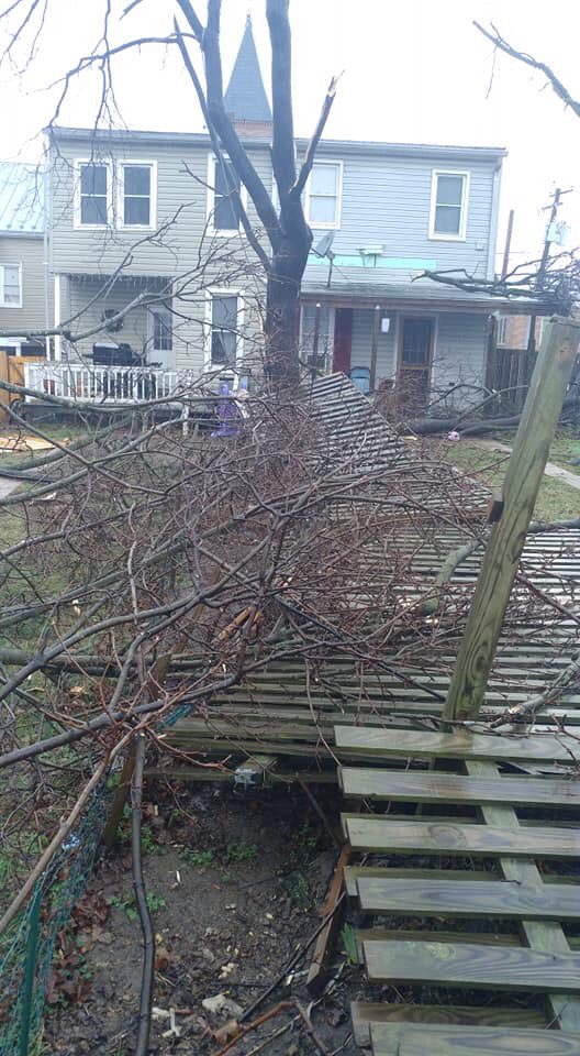
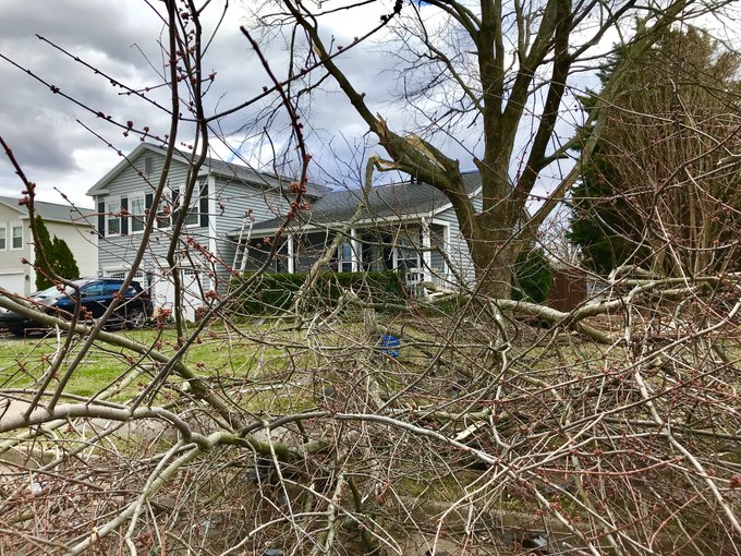
Today, was truly, a remarkable day. I don't think that this has ever happened before, even before I was born in this area. There was a tornado today, along with snow showers today, IN FEBRUARY. There were reports of tornadoes in Poolesville/Dickerson, Westminster, Southern Fredrick County, and Leesburg(Confirmed EF-0 tornado in Leesburg, VA). The damage done was a lot. A wind advisory with gusts 50-60 mph+ today, plus with a severe thunderstorm before 9AM. We didn't get tons of rain, instead, we got... something way better. This will go down in weather history. And to top it all off, there were snow showers tonight, in Damascus and GBurg(probably more places in MoCo as well). Snow in the mountains, blizzard conditions in New England, a bomb cyclone: this storm was definitely remarkable. Today will go down in weather history. All I have to say is... Maryland weather is weird. Update: Snow is becoming much heavier. There is a confirmed EF-1 tornado in Cecil County, MD.
Image
Westminster, MD Tornado Damage(credit: Joseph Bowers)


Flurries after a tornado warning in Damascus, MD. (Credit: Ryan Douglas).
Image


Tornado Damage in Leesburg(credit: Joe Spevak)


Image

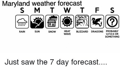
Maryland Weather Meme(credit: Martin Amini)


Featured Post

Archival of Blogger and Move To Substack

Hello everyone, I'm making this post as a formal gesture that I have fully moved to Substack and will not be using this website anymore....