Showing posts with label Wintry Mix. Show all posts

Friday, January 5, 2024

1/6/2024 Small Wintry Mix Event


We have a small wintry mix event for NW of 95 that will result in some minor impacts, with impacts increasing the further north and west you go. A low pressure system will track northeastward off the gulf coast and into the Delmarva as it intensifies over SE VA. Precip will overspread the DMV in the morning, starting out as wintry precip for most. Areas along and E of 95 are expected to see very minimal accumulations and a quick transition to a cold rain. 

As the event progresses, strong WAA will warm the 850 mb temps to above freezing as a warm nose is pushed northwestward, while cold air is still at the surface. Unlike a few days ago, this opens the potential to overall wintry precip rather than just snow to rain. These 850mb temps will vary, with the coldest temps being in the mountains and W of the Blue Ridge. Here, the primary ptype will likely be snow. It is very likely that everyone E of the BR will warm enough to see a wintry mix of sleet, freezing rain, and rain(more wintry precip the more NW you go).


The confidence of this storm is generally very low even this close to the event, due to the extremely tight gradient setting up near the RS line; this is going to be a nowcast event. A 1-3 degree difference will make or break this setup. Due to the preceding temps and low wetbulb temps, wintry precip(where it does happen) should stick pretty easily. The best confidence for significant snow is W of I81, the Catoctins and westward, into the mountain counties. Although it seems surface temps were colder than modeled, the 850 mb temps according to IAD sounding look just as modeled, this doesn't really mean anything yet. Nonetheless, most of the region will see some wintry precip, with accumulations starting as soon as you head N and W from the cities.


Making a snow map for this event was difficult, but here are my general thoughts as of now:

Everyone E of 95 sees all rain, this is medium-high confidence. At the very most a couple of flakes may mix in at the border parts, but very little to no wintry precip is expected here. 95 and just NW is looking to see a T-1"(trace does not mean measurable snow). I think everyone here sees at least wintry precip falling, even with a quick transition to rain. This area also has low confidence, and will setup the start of the very large gradient. The more snow accumulation the more NW you go. Immediately NW of DC/Balt(outside the cities), there is some chance for some very minor ice/snow accumulation. This will be washed away quite quickly however.

The light blue zone(for areas closer to DC) I think will see enough snow/sleet to accumulate, as well as some ice accumulation. This area is extremely uncertain though, with the lowest confidence. The dark blue zone is the same idea as the light blue, but more snow/sleet and more ZR. Again, extremely low confidence in these areas; small temp differences can make or break this.

However, the light blue area near I81 is likely going to see large ice accumulations(potential of 0.1-0.25"+ here). This area is W enough to have enough cold air at the surface but WAA will quickly turn most precip here into freezing rain. The predominant ptype here looks like freezing rain, but some sleet/snow will likely fall.

The purple area is much more confident as this area likely stays snow long enough to see moderate accumulations(3-5"). Even here, there is a slight concern that mixing will cut down a bit, but any mixing shouldn't be too long. The predominant precipitation type here is snow. The red area is the bullseye and the mountainous areas. These areas have higher confidence.


Here are the current onset and warning maps, WSWs are up for just E of I81 and westward, as well as Frederick/Carroll Counties. WWAs are all the way down to the metros, primarily due to ice concerns. Generally, if you can avoid travel near I70/I81, do so, but closer to DC, travel shouldn't be too bad. We see an areawide E of I81 transition to mix and then rain by 10AM to 2 PM.


Thursday, February 24, 2022

Snowflake Prediction for Friday

My snowflake prediction for Friday is 2 snowflakes. Exact percentages are 55% delay, and a 10% chance for closure. The reason I'm leaning towards a delay is because the HRRR is now showing a lot more additional ice on top of what we already have throughout the night. Although temps do rise above freezing, there won't be enough time for it to melt for a full day. I think there won't be a closure because temps will rise very quickly above freezing and melt all of the ice. Even though the ice won't accumulate that much on sidewalks and streets, there will be some slick spots in areas with the simulation the HRRR is showing, at the very least. Some streets and sidewalks could be completely covered in ice, especially in areas like Damascus. The storm looks to be overpreforming a bit right now. HRRR isn't picking up on the freezing drizzle that is happening right now too. Temps dont get above freezing until 7 am on the HRRR for some parts of the county. Because of these reasons, I am confident in a delay but not in a closure. Remember: what the HRRR shows is ADDITIONAL ice. The WWA goes until 10 am for Northern MoCo.

Wednesday, February 23, 2022

Wintry Mix Thursday - Friday

Good evening everyone! We have a threat for a wintry mix from Thursday to Friday, mainly north of DC metro. Models have been trending south and colder for the past day or two. The highest ice will be near the mason dixon line. Unlike the other ice event that busted, this is a cold air damming event, which tends to be undermodeled. This will not be a snow threat, and the main focus of this will be ice and sleet. Although precipitation onset could be snow, almost all of it will turn into sleet/ice quickly. Precipitation onset has been delayed a few hours to after sunset, which would lead to a better environment for ice to accumulate. Main roads most likely won't be a problem, however secondary roads and sidewalks could have some slick spots, especially north of I-70 and in higher elevation areas such as Damascus. A potential delay is possible on Friday, but I won't make a prediction until we get into the event and surface obs.

Now, I will show what some model simulations are for this storm. 


RGEM/RDPS:

This is the RGEM model. It has done quite well this winter. The location of the ice accumulation is realistic, and fits with climatology. However, ice totals are still definitely overdone. The RGEM would give us a scenario for a delay, as ZR lasts in Damascus for until 11a-12p. This solution matches up more with surface temperatures. It has shifted south and colder compared to its last run.


Euro:


Euro is a bit more conservative with the ice totals, but still overdone in some places. It has shifted south and colder compared to its previous run. For Friday 1a, it gives Germantown rain on ptype map, when it should be ZR as temperatures are 32, supporting freezing rain. The Euro and RGEM line more up with my thinking and climatology on where ice accumulations will be.


About the NAM. It has a cold bias and spits out a very cold solution, with ice accumulation for even southern parts of our region. Although it does do well with CAD, it is quite unreasonable. Ground temps will not cool instantly, and NAM assumes it does. As I said earlier, it has a cold bias, so it is also unreasonable in the ptype solution it puts out. Even with later onset time, I just don't see it happening. 


Here is my first call ice map:


I will have an update with a school prediction for Friday and with mesoscale models + surface obs tomorrow.

Sunday, January 16, 2022

Final Call Snow & Ice Maps and Nowcast


These are my final call snow and ice maps. Almost nothing has changed for the snow map, but the ice map has took a change for the good: The 0.1-0.25"+ zone is now gone, and has been replaced with the 0.01-0.1"+ ice zone. Most people will only see up to a tenth of an inch of ice, but the plus is there for the mountains who will have cold air for longer, allowing for longer ice accumulations. Also some localized areas may see amounts just above a tenth of an inch. Cold air was undermodeled and WAA was overmodeled on high res models if you look at radar. This could mean a longer time period of snow, and just in general wintry precipitation. Surfaces will be below freezing for a while even when temps start to rise above freezing.

Saturday, January 15, 2022

MLK Weekend Storm - What to expect

Good afternoon everyone! We have a winter storm threat to track tomorrow and Monday morning. This threat is looking more like an ice threat instead of a snow threat; but if you live north and west of I-95 you will still see some snow accumulation for this storm. Unless you're far north and west(along and west of I-81), you probably won't see an optimal amount of snow - if you like snow. This storm takes an inland track - so being even a little bit more west can make a difference. When the snow starts, it will be heavy, with rates 1-3" per hour. When it snows, it will thump. Wind gusts up to 45 MPH are possible with this storm, creating the possibility of downed trees and spotty power outages, especially when ice starts to take over the snow. I would recommend to stay off of the roads(if NW of I-95) on Sunday-Monday, as the snow with ice makes roads very slippery and impassible at times. There is a very cold airmass in place for the storm, so ice and snow will stick longer to untreated surfaces. Please note that freezing rain can happen even above freezing, if surface temps and wet bulb are still <32. There is a winter weather advisory for all of MoCo, with 1-3" expected and up to 0.1" of ice. Just north of us is in a winter storm warning, for 2-4" of snow and 0.1-0.3" of ice.


NAM12KM:


Note: at the time where it shows pink for our area(7 PM), I looked at a sounding for Germantown/Gaithersburg and it would seem as if it would be sleet, rather than freezing rain. Still, you can see everyone starts off as snow, and then the warm nose comes in, turning into sleet, then freezing rain, and eventually, when the CAD breaks, cold rain. 


Ice total and snow total maps, pretty self explanatory.


NAM3KM:


The NAM high res shows everyone starting out as snow, then going to ice, and then going to plain rain. The NAM 3KM also shows some backend snow, which is interesting. However, it seems to be light snow, and probably wouldn't amount to much. A lot of the rain will wash all of the snow away, so even if 3" fell, it wouldn't look like it.


The reason why the NAM 3km shows a lot of ice is because of strong southeasterly upper level winds, forcing warm air into the atmosphere and creating a warm nose that gets more dense as time goes on. Eventually, the cold air at the surface breaks, and areas east of I-81 switch to cold rain.


 One other thing I want to talk about is the wind gusts. At this time(8P Sunday), freezing rain is falling all throughout the region. With the strong wind gusts(40-50 MPH wind gusts), isolated power outages and downed trees is likely. I would recommend everyone north and west of I-95 to get ready to deal with some time w/o power, just in case.

*Editors Note: While I was writing this, the 18z NAMs came out, all of the models shown are from the 12z suite

My snow and ice forecast:

(I apologize for very low quality maps, Blogger won't let me put high quality pictures) 


My next update for these maps will be tomorrow morning, after 12z mesoscale runs come in. I'm going bullish with my forecast because I think there will be heavy enough rates for a large enough area to get 2-4" before the changeover to sleet, freezing rain, and then cold rain. I think the NAM is too bullish on the warm air coming in very quickly and changing over to rain, so I didn't use the NAM that much in my forecast. Other models look pretty good for our region in terms of snow, such as the Euro, GFS, and HRRR. My final call WILL be tomorrow morning, after 12z HRRR, and both NAMs come in.

To conclude, I expect 2-4" of snow(possibly more in localized areas) for Northern MoCo and 1-3" for Southern MoCo. For ice, I expect 0.1-0.25" of ice for the general area, with possibly more in localized areas. Timing onset will be in the afternoon, at 1-3 PM. This will be a high impact storm, especially west of I-81, and also for NW of I-95, not just for snow, but for ice. I am very concerned about the ice threat, since CAD is usually undermodeled, especially on global models, and the ice combined with the strong wind gusts could create widespread power outages and downed trees. I'll have a quick update tomorrow, and then I'll do a nowcast.


Sunday, December 26, 2021

Wintry Mix Tomorrow

Good evening everyone! Tomorrow morning, some freezing rain, sleet, and snow is possible for our northern areas. This event will not be significant at all, and I expect minimal accumulations, up to a coating of slushy snow; with all of the (possible) accumlation on grass, with roads staying wet.  Those small amounts may not even occur in the first place. A cold front pushing through this evening creates dew points below freezing, with surface temperatures in the 30s(mainly for northern areas). The event will start out as sleet or snow for northern areas, and then switch over to rain as soon as temps rise. Other than the mountains, icing/snow will not be a threat due to how warm its been recently.


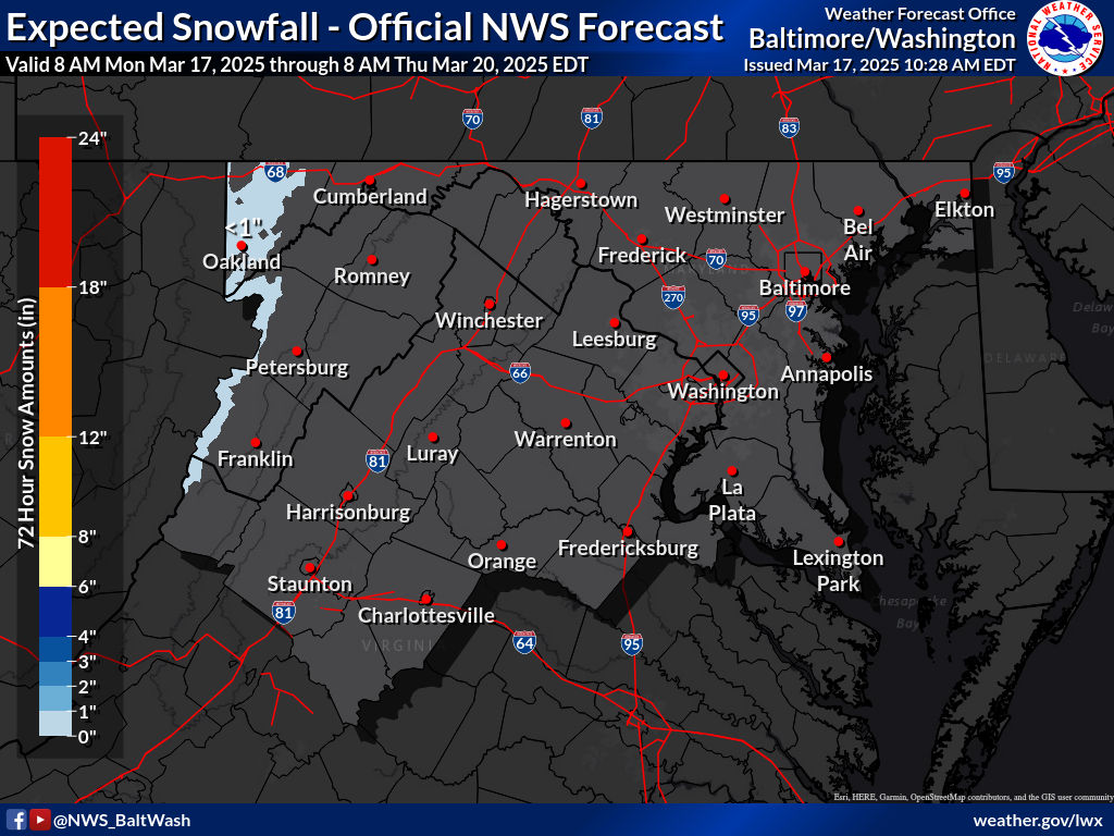
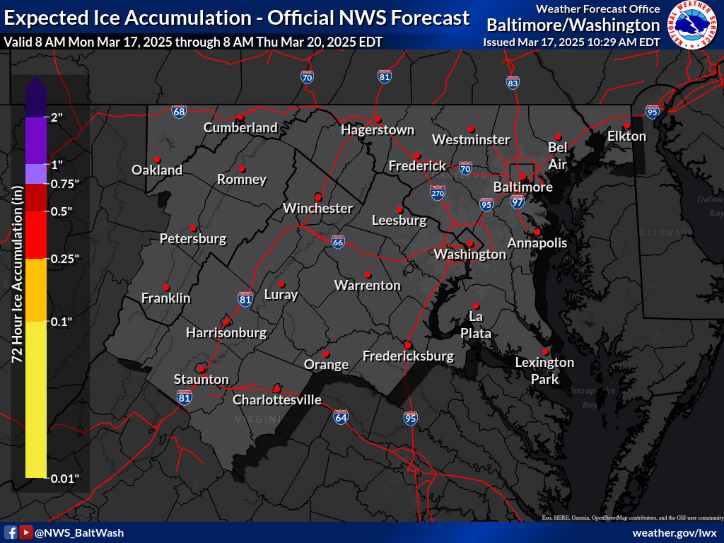
These are the winter weather maps expected by the NWS:

Expected Snowfall - Official NWS Forecast 

Most Likely Ice Accumulation 

Plume for Northern Maryland(Frederick):

As you can see, this plume shows all type of precipitation, with rain being the dominant precipitation. It shows pink(sleet), red(freezing rain), blue(snow), and green(rain). It shows it starting in the early morning, and then as temps rise, the cold rain starts to take over the mix, and eventually wins over the wintry precipitation. The plume mean shows a trace-dusting of snow for Frederick, Maryland. When the rain chances increase in the plume, thats when the precipitation get mixed with rain.


This is the 0z HRRR for tomorrow. It shows an early batch of rain quickly moving through before the snow and mix arrives. When the quick batch of rain arrives, its not cold enough at the surface to support wintry precipitation, so therefore the precipitation falls as rain. However, when the heavier precipitation comes to our area, upper level temperatures are cold enough to support wintry precipitation even with mid 30s at the surface. If the snow falls at a heavy enough rate, there could be a light coating on the grass in some areas. 

To conclude, a wintry mix that transistions to rain is likely if you live north of DC and I-66. It may lead to a possible slushy coating, especially in our more far northern areas. This event will not impact the roads or sidewalks, unless you travel north of the Mason-Dixon line, where WWAs are posted. Precipitation becomes less likely south of DC, and these areas will see just rain, with a very very low chance of mixing.

Wednesday, March 31, 2021

April Fools Snowstorm Update

5:50 PM Update:

As many people saw snow from a heavy snow band that pushed through our area, many bands are still coming through and still forming in PA. We have a chance for snow bands to come through our region throughout the rest of the day and night, and even a chance early morning tomorrow! As north winds gust and pull in cold air and as the sun sets and temps drop, some of these bands may fall when its below freezing, and may cause some accumulation! Not much is expected though, only up to an inch; up to 2 inches at the very most. Sun angle issues will be removed, and if the temps are below freezing accumulation could easily happen. Keep hoping! This was better than a lot of models were saying.

7:30 AM Update:

As the main course of precipitation moves out of our region, there is still chance for some flurries/snow showers with mostly light but sometimes heavy-moderate snow to come south from PA throughout the day and into the night. In the night, it may be below freezing when they come. North winds will create showers in the afternoon that may have snow mixed with them. Snow was confirmed on radar in northern Frederick and Carroll counties and may have coated the ground there. However, mixed snow reports go much more further east and south than that, and I can confirm one here too. Anyways, we still have a chance to see some snow, mixed with times throughout the day if you don't live in a northern place and/or aren't an early riser. There is a chance for some accumulation, mainly after sunset when temps will start to plummet towards freezing. It won't be much unless that precip is heavy.

Tomorrow is the beginning of April... and to start it off we have a chance for some snow to fall. Models have been jumping back and forth with this system, and 12z runs weren't looking that good, but 18z runs look a bit better. The cold front is coming through, and has reached into western Maryland at 5 pm. I don't know if this is earlier or later than expected, but I'll assume this is around expected. I'll keep updating this specific post if anything major changes. Let's jump right into the models!

 GFS:

The GFS shows rain turning into an isolated part of snow before the main system moves out, and shows lingering rain/snow showers staying for a while before completely moving out. After hour 18(7 AM), the 540 line is south of our county. This is good because it means that our county is generally suitable to get snow. The lingering snow/rain showers between hour 21-27 should generally be snow, possibly mixed with rain.

Now I want to talk about the isolated snow spot at hour 18. We have northwest/north winds up to 700 mb in this sounding, which will bring in cold air. The precipitation type maps plus precip type on sounding all say snow. However, we are under the 540 line at this time, which isn't favorable for getting snow. We also have temps well above freezing. This would likely not be all snow even for Damascus and would probably be mixed with rain. These are somewhat heavy precip types and will cause dynamic cooling, something the models don't handle well so we will see how this plays out.

The GFS shows around an inch for that area in that spot of snow at hour 18. I wouldn't think this much would fall, since rain mixing would hinder with accumulation, but this could happen if we saw less mixing!


NAM(12km):

The NAM shows all rain on the ptype map for all of MoCo, but the thing is its glitching a bit. At hour 18(7 AM), most of the county is under the 540 line and still rain. Even if not snow, it would still at least be snow. 

This sounding shows north/northwest winds up to 700 mb, and temps at 39F. Even on the precip type guess, it says snow. It would be difficult to have pure snow with this sounding, so there would likely be mixing with rain. Even so, the ptype map is wrong and it should show some snow above 540 line.

It shows no accumulating snow for our region except for western Maryland, but this map is glitched.


European:


The European doesn't show any wintry precip for any of our region, but there is a high chance that in the break between hour 24 and 30 that there is some sort of wintry precip, mainly for our northern areas. I cannot see soundings or 540 lines so it's harder to interpret this.

The Euro(10:1 ratio NOT Kuchera) shows no snow except for northwestern Frederick County.


This event is very difficult to forecast. A small difference in temps could mean snow or no snow. A cold front is pushing through and a second cold front will push through tomorrow as well. If we don't get snow from the main event, we may get snow from the lingering snow bands after the main course of precip, and it may be below freezing when we might get them. For a snow forecast... it's too difficult to make one.  We might not see any accumulation at all or we could see 1-3 inches. North and west of MoCo has the best chance, but this storm favors more inland than more north(although being more north always helps)! Models won't be useful past this point, and its better to use other tools. This may be the last snow threat of the year. Either way, April Fools!


Wednesday, March 17, 2021

Severe Weather and Snow Threat Thursday - Friday Update

We have a needed storm that is coming up tomorrow and will last into Friday afternoon before tapering off. And there is the potential for some snow as a secondary cold front pushes through the area on Friday. Other than the snow, why do I say this is well needed? Well, we haven't had much precipitation in the area since the end of February. Up to 2 inches of rain could fall in our region! This is well needed for plants to thrive. Although we aren't in a drought, it has still been a while, and it will be good for everyone. And, as you may have noticed by the title, there is the possibility for SEVERE WEATHER on Thursday! I am pretty sure you would have heard about the crazy and dangerous weather going on in the really southeastern part of the US.


A high risk and a 45% chance of a tornado occurring for any one location in that area are nuts! In those areas, significant strong tornadoes(EF2 and above) are likely. And on Thursday, there is a chance for some severe weather in our region; locally! I'll go above it below.

Our whole region is under some sort of color! For most of Maryland, some non-severe isolated thunderstorms are possible. However, in our western and especially southwestern areas, a marginal risk for severe thunderstorms exists. In our extreme far SW suburbs of the DMV, a slight risk for severe thunderstorms exists, including a small risk of an isolated tornado forming(2% - 5%). A marginal risk means that some severe storms could be spotty, but will be limited in duration or intensity. There is, and I cannot stress this, still a risk for tornadoes, damaging wind, and hail in areas in a marginal risk. It is just in those slight areas where more, stronger tornadoes, more widespread and damaging hail, and winds are likelier. The main reason why parts of our area are in the "marginal" zone is that there is mainly a risk for hail.  The biggest impacts are in the Carolinas, where widespread, damaging tornadoes, hail, and wind are expected. If your area is in any color on the SPC map or any specific place(s) I mentioned, get ready for dangerous severe weather. Make sure you have enough food and water to last for at least a week, have a shelter/safe spot in your house, and have a radio or some sort of device that can get up-to-date warnings and watches issued by the NWS.

Anyways, back to the snow aspect of this storm. We will start to switch over into wet snow in the early morning hours of Friday and will keep snowing until it starts to taper off. As you might have expected, areas north and west of MoCo will see more hours of snow. Over the past 2 days, the storm has been trending more south. As we switch over into the snow, it may be mixed with sleet/rain. However, as the cold front pushes SE, it should be primarily snowing if you live in MoCo, and generally most of the area. Winds may gust of to 20 mph, so conditions will get worse on Friday. The models have been doing some wacky stuff with the snow amounts though, and I will be looking at them regardless.

NAM(12km):

The NAM shows moderate-heavy rain before we start to switch over to snow, and then that snow band pushes southeast. However, around 8am Friday, I do want to point out something. It shows heavy snow in a lot of Southern Maryland. There is one thing wrong with it. If you look at the 540 blue line, it sets up right around Rockville(the thing about this line I will say now applies to all of the models). Generally, any area below that line(if they aren't bordering the blue line) will not be snow and instead sleet, or cold rain, since temps are above 32 at this time for most of the area(even for those who are above the blue line). This will cause an error in the snow totals, and since this model shows heavier precip in Southern MD, and shows it as snow, will cause a ridiculous uptick in snow totals. Take the snow maps I show with a grain of salt.

This snow map is utterly ridiculous. It shows up to 6 inches of snow in some areas of SoMD. That, will not happen. And even more stupid, is that almost Frederick county has no accumulating snow at all. Yeah, this won't be playing out at all. It shows a coating to a little over an inch of snow in MoCo, with the most snow somehow in SE MoCo. This will not happen.

GFS:


The GFS shows much heavier precip compared to the NAM. It shows heavy rain hitting us before that cold front moves down and switches us over into heavy snow, before eventually tapering off. Now, the GFS does a much better job than the NAM with its 540 blue line, as most areas that are below that blue line are shown as rain, and areas north are shown as snow. However, I still am a little bit skeptical of the snow map.


The GFS is much better than the NAM, but it still is a little bit ridiculous with the highest totals in our area being on eastern Anne Arundel and Northern Calvert County. In MoCo alone, a little less than an inch to a bit more than 2 inches is shown by the GFS. At least it shows more than an inch of snow in Washington and Frederick counties. Even though the GFS does show the heaviest precip once the cold front pushes down in Anne Arundel and Calvert Counties, and dynamic cooling will likely be there, I still think it's still wrong, as north and west areas will see the cold air that is required for wintry precip first, giving those more snow. They will also be able to maintain snow on the ground longer. However, it definitely is on to something with that area getting the most snow in our area, and it is something to watch. Either way, the highest snow totals from this storm north and west of Montgomery County. We want a stronger storm and not a weaker one, even if the jackpot totals(southern New England) aren't pushed south.

Euro:

The European shows heavy rain before the transition to snow as the cold front snow. However, it shows the heavy precip moving out of here before the cold front has come through our area enough to cause snow. It still shows us having some light-moderate snow, but it won't amount to much.

It shows up to a coating of snow, with the most snow in our region in our NW areas. Now, I think the European model is the most accurate out of all of the models in terms of where the highest totals will be; north and west of MoCo. I don't agree with how low they are though, I think the cold front will be pushing south fast enough for some of the heavier precip bands to be heavy snow. We will see though.

So since this is a rain to snow event, and it will be raining for the most part on Thursday, I will make an update on Thursday, this time with live radar and condition updates, including some models. I won't make a snow forecast until tomorrow, since there are so many things that could go wrong and we don't get anything or something goes better than planned and we get much more snow than expected. Right now, I am thinking of a trace to an inch in southern MoCo and a coating to 2 inches in Northern MoCo, with some isolated areas, possibly pushing 2 inches. 3" is not out of the question if the cold air pushes in faster or the heavy precip lingers for longer.


Tuesday, March 16, 2021

Snow Threat on Thursday Night - Friday?

 I have been monitoring a snow threat all week, but I didn't make a post on it earlier because it looked like just rain for us and a winter storm for New England. However... model run trends today made me reconsider my decision, as we still may see some snow out of this due to it trending south. This isn't a windshield wiper(trend south and then north again), since almost all models have been trending south since midnight. However, there still may be a last-minute north trend. This is a rain to snow event. Everyone will start as rain, in the DMV, and even in the interior Northeast. However, as a cold front starts to move in Friday, we may transition over into a mix, and then possibly snow. It depends on how fast this cold front comes in. If it comes in faster than expected, we will see more snow, however, if it comes later than expected we won't see ANY type of wintry precipitation. As with many storms these years, a small change in temperature could be the difference between some snow and just plain cold rain. Heavier precipitation gives us a higher chance of snow too due to dynamic cooling. Let's look at some models.

GFS:


The GFS shows moderate-heavy rain before eventually turning into snow. However, if it has been trending southeast, that means that the cold front will push faster southeast, meaning that it is possible that we could be heavy snow when it shows heavy rain if the cold front pushes fast enough. Even when we switch back to snow, ratios will be less than 10:1. As we transition, the precip starts to weaken out.

The GFS has been consistently trending southeast since midnight runs today, and shows around an inch of snow for most of MoCo. The highest totals are still in New England. However, it has been trending for a weaker storm in those areas that are in the bullseye, but for those areas, 3-6 inches isn't bad.

NAM(12km):

The NAM shows us having moderate-heavy rain before switching over into snow. It gives us 4-7 hours of snow, but for the most part, the snow ratio will be below 10:1, meaning less snow. In my opinion, it's fixed itself from the 12z run because that was stupid. 6-8 inches in Ocean City won't be happening. According to snowfall maps, it has been trending north, then south, then north, and then south. It has been consistently showing a stronger storm, showing more and more snow for areas in the bullseye.
The NAM shows a coating to 1.5 inches of snow, with the most snow in northern areas. However, do you see that isolated purple spot in western Washington and eastern Allegany counties? That is pretty close to us. The HIGHEST totals are in New England, as expected, but if we trend southeast again, that isolated heavy snow spot could go right to MoCo! Something to watch.

Euro:


Euro shows as starting as rain, as other models do. However, they don't show any snow in this forecast. This could be because the next precip picture is 6 hours after the previous one. If I had a one-hour timestamp map, I think it would at least show some flakes. It has trended a bit southeast for us, but it also trended north with the bullseye, as you will see by the 10:1 snowfall map below.


The European shows no accumulating snow for most of MoCo(except a coating in southern MoCo that borders DC). However, it shows 1-3 inches for the Delmarva/Eastern Shore area?? This is a 10:1 ratio, and ratios will likely be lower than 10:1, so there will be less snow.

Right now, it is too early to make a snow forecast, since we are just possibly back in the snow game. If I had to guess right now though(not a forecast), a coating to 1 inch of snow, with some isolated areas in Northern MoCo getting a bit more(up to 2 inches max).  The more NW you are with this storm, the likelier you will see snow or just wintry precipitation in general. I will make an update tomorrow. 


Featured Post

Archival of Blogger and Move To Substack

Hello everyone, I'm making this post as a formal gesture that I have fully moved to Substack and will not be using this website anymore....