Showing posts with label High Wind. Show all posts

Sunday, December 10, 2023

12/10/2023 Accumulating Snow Event NW of I95

 Guidance has converged on an anafrontal system with a secondary low that provides the opportunity to see some snow, as moisture is thrown from the secondary low into the cold sector. Thus, this gives us to potential to see snow falling, with (light) accumulation prospects NW of 95.


SYNOPSIS:

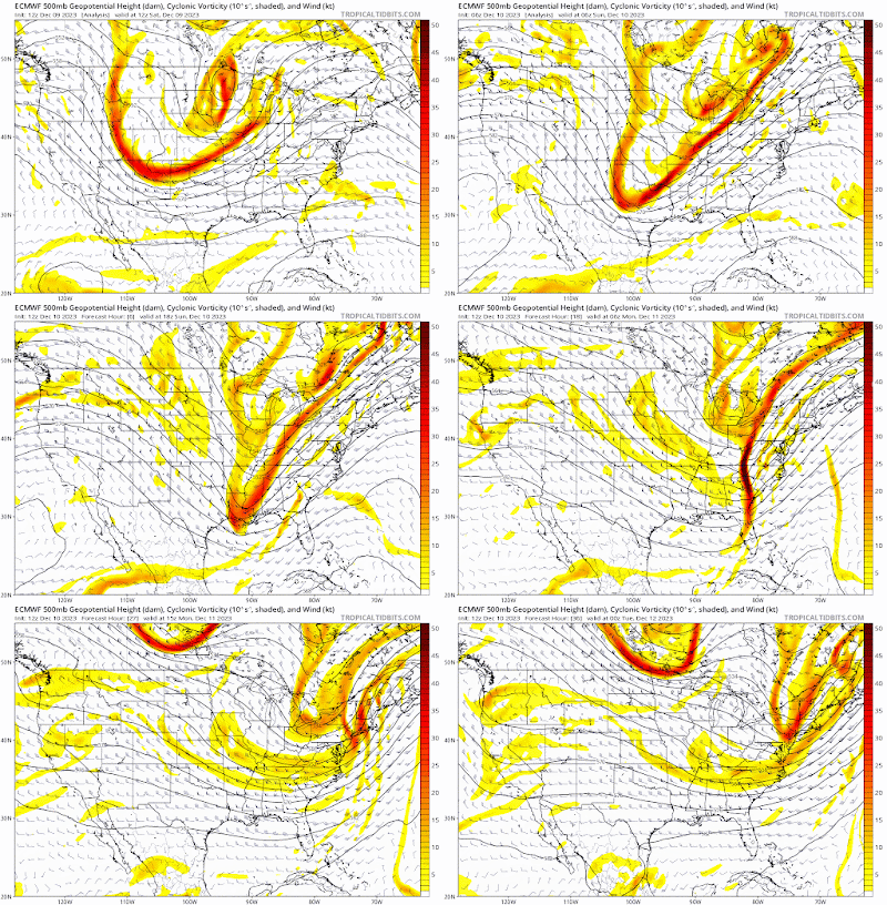
A shortwave, which has already moved through the country and continues to do so has a cold front ahead of it and northern piece energy. The trough axis is delayed behind the front, so we set up an anafrontal event(not typical).


 This system overall is very dynamic and should have good PVA in front of it which induces cyclogenesis(intensification of the storm) and moisture advection. Temp gradient is also quite large, with the airmass behind the cold front being Canadian and the airmass in front of it being subtropical.


We also have a dual jet setup associated with this which pops a secondary low when the trough becomes negatively tilted, in the Carolinas. This directs winds and moisture return NW.


The large temp gradient should allow for frontogensis forcing, which will make precip rates extremely high. CAA driven snow will occur in the overnight hours after midnight for most people as temps drop.


One thing to note about this system is that surface temps are extremely marginal, but the rest of the atmosphere is <0C, allowing for it to snow. These heavy precip rates will allow for greater dynamic cooling and a saturated column.


OBSERVATIONS:
We are now less than 12 hours away from snow, and the use of models is useless. As of 23z(6P EST), the trough is netural-slightly negatively tilted over MS/AL.


This is ahead of schedule, as it was supposed to be this way at 7-8 PM. This will have better implications downstream as a earlier negative tilt will allow for cold air to fill in faster during the snow, and the secondary low to pop more/quicker in a favorable location.

The cold front was also ahead of schedule, and stronger than modeled, passing the BR by 515-530 PM. 

Temps are dropping quite quickly behind the front, with some station reporting degree drops every 4-5 minutes. Although it is worth noting that sfc temps are warmer than on NAM, they are colder than on HRRR(behind the front), and it just initalized at 22z


The rate temps are dropping behind the CF, catching up to NAMs temps wouldnt take too long either. It's running too warm for some parts of nova at 0z anyways. We'll see though, eitherway temp wise we look good.

And now we look at the radar, we are starting to see the backside precip fill in and amplify. It looks very good with convection off the Carolinas. This system is absolutely juiced, and is exceeding expectatations. 


So overall, it might be safe to say that this event is going slightly better than expectations. Observations look great so far and is expected to continue into the event. 

Overall:

Overall, despite uptrends, the general picture is the same: accumulating snow for NW of 95, mainly in higher elevations. Temps will be very marginal(32-36), but we might push colder during heavy bands due to CAA. That being said, we need heavy snow rates to stick. Otherwise, it will not stick; moderate or below will not do it. Mesoscale banding features are too hard to resolve at this range, so there is no really saying where it will be, but if I had to guess it would be somewhere around here(NW of the fall line): 

As for snowfall, there will be an extremely sharp cutoff on I95. I have trouble thinking anyone inside or east of the beltway will see more than just white rain, with little to no accumulation. Elevation is just too bad there to get anything substantial. Temps will be too marginal there for anything. Even further NW, temps will remain 32-36 for most of the storm, with the exception of lower temps 1000'+ or in the bullseye areas. The reason I'm even going this bullish on accumulations is because of the puking snow rates that will set up somewhere that will stick to the ground despite temps. The rates cannot be moderate or light, they have to be heavy, but we know it will set up somewhere,, and that area should see nice accumulations. Having heavy wind should also help blow the snow around and even help with stickage as wind removes latent heat release; it would help us more than hurt us. This, along w/ heavy rates will make for low visibillity conditions. 

As of N of the fall line, I gave the highest amounts to areas 700'+ elevation and west of I81. The bullseye for this storm overall will be the Blue Ridge and the Apps, as expected. Locally, the bullseye is probably the Parrs Ridge if I'm betting.  In the Parrs ridge, there could be a spot of over 3"+ if everything goes right. I went extra bullish based on new data we have, but this could very well bust. I feel like this is a boom/bust type setup; either we do really well with banding and get puking snow for hours accumulating to over an inch, or we generally stay mostly rain with no acccumulation even if it snows. Ratios will be very low; likely 4:1-7:1 depending on your location.


And as for school impacts, models have trended earlier with the event, generally wrapping snow 5-7A through the region, but before that it will be absolutely puking, along with strong winds as the low intensifies and moves NE. The snow will melt extremely fast afterwards, but I still think theres a chance we could pull off a delay. I'll go 2 snowflakes(50% delay) for this event, if band is a bit later then we'll probably delay. If we can get a WWA in place we probably delay, but it can go either way. Accumulations will mostly be on grassy surfaces, but depending on rates, could be on some side roads and sidewalks. Overall, this event should lock in Dec measurable snow for most areas, and should be really nice to see. 


Saturday, January 15, 2022

MLK Weekend Storm - What to expect

Good afternoon everyone! We have a winter storm threat to track tomorrow and Monday morning. This threat is looking more like an ice threat instead of a snow threat; but if you live north and west of I-95 you will still see some snow accumulation for this storm. Unless you're far north and west(along and west of I-81), you probably won't see an optimal amount of snow - if you like snow. This storm takes an inland track - so being even a little bit more west can make a difference. When the snow starts, it will be heavy, with rates 1-3" per hour. When it snows, it will thump. Wind gusts up to 45 MPH are possible with this storm, creating the possibility of downed trees and spotty power outages, especially when ice starts to take over the snow. I would recommend to stay off of the roads(if NW of I-95) on Sunday-Monday, as the snow with ice makes roads very slippery and impassible at times. There is a very cold airmass in place for the storm, so ice and snow will stick longer to untreated surfaces. Please note that freezing rain can happen even above freezing, if surface temps and wet bulb are still <32. There is a winter weather advisory for all of MoCo, with 1-3" expected and up to 0.1" of ice. Just north of us is in a winter storm warning, for 2-4" of snow and 0.1-0.3" of ice.


NAM12KM:


Note: at the time where it shows pink for our area(7 PM), I looked at a sounding for Germantown/Gaithersburg and it would seem as if it would be sleet, rather than freezing rain. Still, you can see everyone starts off as snow, and then the warm nose comes in, turning into sleet, then freezing rain, and eventually, when the CAD breaks, cold rain. 


Ice total and snow total maps, pretty self explanatory.


NAM3KM:


The NAM high res shows everyone starting out as snow, then going to ice, and then going to plain rain. The NAM 3KM also shows some backend snow, which is interesting. However, it seems to be light snow, and probably wouldn't amount to much. A lot of the rain will wash all of the snow away, so even if 3" fell, it wouldn't look like it.


The reason why the NAM 3km shows a lot of ice is because of strong southeasterly upper level winds, forcing warm air into the atmosphere and creating a warm nose that gets more dense as time goes on. Eventually, the cold air at the surface breaks, and areas east of I-81 switch to cold rain.


 One other thing I want to talk about is the wind gusts. At this time(8P Sunday), freezing rain is falling all throughout the region. With the strong wind gusts(40-50 MPH wind gusts), isolated power outages and downed trees is likely. I would recommend everyone north and west of I-95 to get ready to deal with some time w/o power, just in case.

*Editors Note: While I was writing this, the 18z NAMs came out, all of the models shown are from the 12z suite

My snow and ice forecast:

(I apologize for very low quality maps, Blogger won't let me put high quality pictures) 


My next update for these maps will be tomorrow morning, after 12z mesoscale runs come in. I'm going bullish with my forecast because I think there will be heavy enough rates for a large enough area to get 2-4" before the changeover to sleet, freezing rain, and then cold rain. I think the NAM is too bullish on the warm air coming in very quickly and changing over to rain, so I didn't use the NAM that much in my forecast. Other models look pretty good for our region in terms of snow, such as the Euro, GFS, and HRRR. My final call WILL be tomorrow morning, after 12z HRRR, and both NAMs come in.

To conclude, I expect 2-4" of snow(possibly more in localized areas) for Northern MoCo and 1-3" for Southern MoCo. For ice, I expect 0.1-0.25" of ice for the general area, with possibly more in localized areas. Timing onset will be in the afternoon, at 1-3 PM. This will be a high impact storm, especially west of I-81, and also for NW of I-95, not just for snow, but for ice. I am very concerned about the ice threat, since CAD is usually undermodeled, especially on global models, and the ice combined with the strong wind gusts could create widespread power outages and downed trees. I'll have a quick update tomorrow, and then I'll do a nowcast.


Thursday, June 3, 2021

Severe Weather for the DMV Update

 5:55 PM UPDATE:

Now that the storm has passed, I can type what I saw. I saw flooding, lightning strike right in my neighborhood, 0.5-0.75" hail, winds blowing everything in its path. I lost power for a couple of seconds and lost wi-fi for 2 minutes.

5:45 PM UPDATE:

Image 

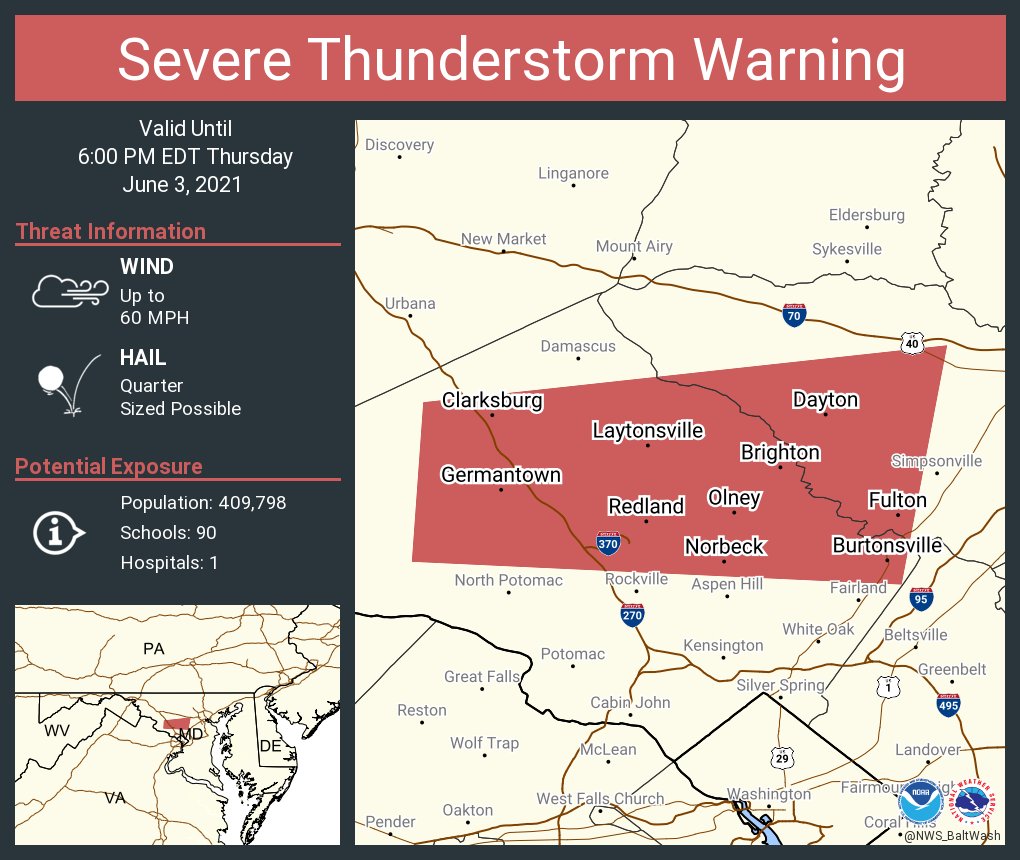
There is a severe thunderstorm warning for Germantown and Gaithersburg! Expect 60 MPH wind and quarter sized hail.

5:13 PM UPDATE:

Severe storm for parts of MoCo. Main threat are 60 MPH winds and quarter sized hail.

3:55 PM UPDATE:

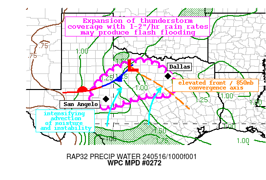
Graphic for MPD #0272 

For MoCo, and eastern and northern areas, the WPC has issued a mesoscale discussion for the potential of 2-3 inches of rain through 9 PM. 

3:53 PM UPDATE:

Image

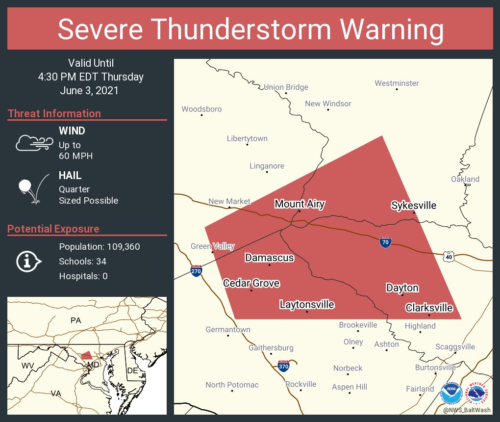
The NWS has issued a severe storm warning for Damascus. The main risk are 60 MPH wind and quarter size hail.

3:20 PM UPDATE:

Image 

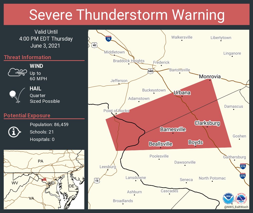
THERE IS A SEVERE THUNDERSTORM WARNING FOR CLARKSBURG, BOYDS, BEALLSVILLE, AND BARNESVILLE MARYLAND! THIS INCLUDES NORTHWESTERN MONTGOMERY COUNTY AND SOUTHERN FREDERICK COUNTY. 60 MPH WIND AND QUARTER SIZED HAIL IS POSSIBLE. SEEK SHELTER NOW!

3:15 PM UPDATE:

 
The 3:10 PM surface CAPE analysis shows 2500-3000 surface CAPE for all of MoCo and DC, and 2000-2500 elsewhere. This is more than enough to cause a severe weather outbreak, and is favorable for tornadoes to be produced.

The 3:15 PM EDT mesoscale analysis shows 1500-2000 MLCAPE for MoCo and DC, which again, is a good amount for severe weather. The shear generally remains the same, don't see too much of a difference.

2:50 PM UPDATE:

Image 

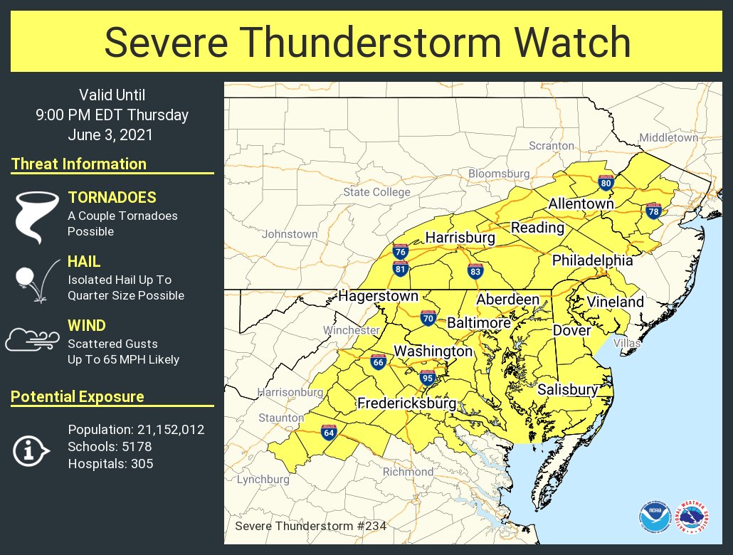
THERE IS A SEVERE THUNDERSTORM WATCH FOR ALL OF THE DMV! A COUPLE OF TORNADOES ARE POSSIBLE, AND ISOLATED HAIL UP TO 1" SIZE(QUARTER SIZE) IS POSSIBLE, AND WIND GUSTS UP TO 65 MPH IS LIKELY! 21.5 MILLION PEOPLE, 5200 SCHOOLS, AND 300 HOSPITALS ARE AFFECTED BY THIS!

2:35 PM UPDATE:

Winds are starting to shift east, slowly but surely. If winds are able to switch in time into the southeast direction, this would help tornadic activity.


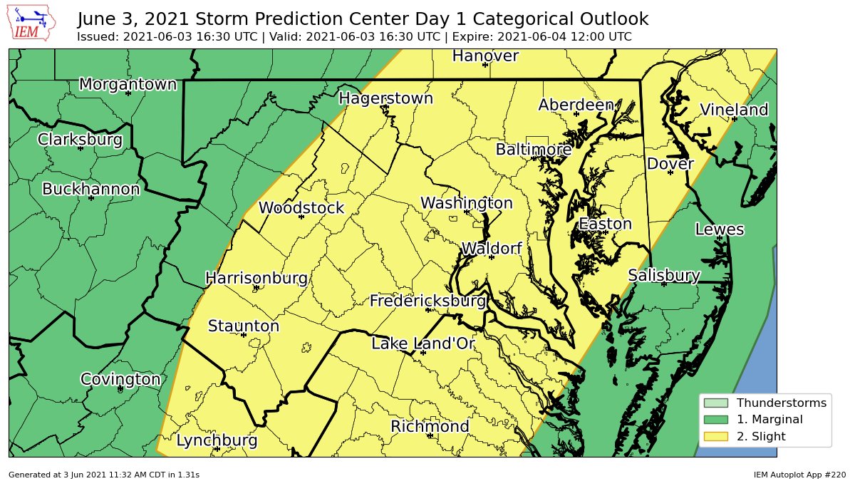
As most of you know, there is a severe weather risk today for the DMV. Not too much has changed since yesterday, and all of the DMV, including MoCo, is in a slight risk. The only major difference is that there isn't a hail risk for the northeast anymore, and the main risks are isolated tornadoes, damaging winds, and localized flash flooding. In this post, I will be looking at  2 models, the NAM 3KM and the HRRR. I will also be using mesoscale analysis from the SPC. The main timing is between 2-10 PM. MD, VA, and NC will likely have more severe weather due to the widespread clearing and higher moisture content. The SPC has us in a 2% tornado risk and a 15% wind risk.


NAM 3KM:


This is the sounding from the NAM at 4 PM EDT for Northern MoCo. It shows a critical angle of 86, which is good, and severe weather(not marginal severe). It shows 2000 MLCAPE(CAPE in atmosphere), and around 3100 CAPE at the surface. The dew point is 69, which is good as it brings moisture. Lapse rates are good, shear isn't that great, and storm relative velocity is pretty bad too. Overall, this sounding is decent for severe weather.


The NAM shows pockets of 2000+ MLCAPE(Mixed-Layer Instability) in MoCo and the DMV, and 1500-2000 MLCAPE elsewhere(generally near the pockets of 2000+ MLCAPE). This is more than enough for a severe outbreak and even tornadic activity. Jim Cantore, an official meteorologist, thinks there's a tornado risk for DC and parts of the DMV.

The NAM 3KM shows a good amount of shear in the atmosphere at 8 PM EDT. Areas in the pink are in 50-60 KT of shear, which is more than enough for a severe outbreak.

HRRR:


The HRRR(15z) shows 1000-1500 MLCAPE in the blue and 500-1000 MLCAPE in the gray. The SPC thinks that there should generally be 1000-1500 MLCAPE for areas southwest of the Mason-Dixon Line.


The HRRR shows 50-60 KT of shear in the pink areas, and 30-50 KT of shear elsewhere. This is a decent amount for a severe outbreak.


The HRRR shows a decent sounding for severe weather at 4 PM EDT. It shows around 1200 MLCAPE, 1750 surface CAPE, a good dew point, good critical angle, good lapse rates, meh shear, and an ok SRH. Overall, not too bad for severe weather.


SPC Mesoscale Analysis:


 The SPC mesoscale analysis at 1:10 PM EDT shows already a decent amount of MLCAPE. 1000-1500 MLCAPE for a lot of the region, including MoCo and DC, and a pocket of 1500-2000 MLCAPE just west of DC. In our northern areas, 500-1000 MLCAPE remains.


The SPC mesoscale analysis at 1:30 PM EDT(most unstable CAPE) shows a lot of CAPE, including 2000-3000 in areas south of Frederick. In our northern areas, 1000-2000 CAPE lies.(this is most unstable by the way, MLCAPE is more important).


The SPC mesoscale analysis at 1:14 PM EDT shows 30-40 kt of shear for most of our region. This is in the range of good shear, and supercells become more likely as this number increases(surface-6km shear).


As more updates come in, I will update this post. The timing is between 2-10 PM, main threats are isolated tornadoes and damaging winds, but flash flooding is possible, slight risk for DMV, good amount of shear and MLCAPE, and be prepared for these storms.


Wednesday, June 2, 2021

Severe Threat for the DMV Tomorrow


There is a severe weather threat for the DMV tomorrow, with the main threat being damaging winds. An isolated tornado or (large) hail cannot be ruled out though. The SPC has issued a slight risk(2/5) for most of our region. An enhanced risk(3/5) is possible tomorrow, and I wouldn't be surprised if parts of the DMV get an enhanced risk. There will be modest CAPE and a decent amount of shear. Instabillity will be able to build, even with cloud cover, due to strong warm air advection. And model soundings are also starting to suggest cloud breaks tomorrow. 


As you can see, there is a 2% chance of any tornado occuring in the green area 25 miles away from any given point.


There is a 5% chance to see 1" or larger(not the chance for less than 1" hail) 25 miles away from any given point in the green area.

There is a 15% chance in the yellow area to see winds 65 MPH or higher winds 25 miles away from a certain point, and a 5% chance in the green area to see winds 65 MPH or greater 25 miles away from a certain point.


The HRRR shows modest MLCAPE at 11 AM EDT tomorrow, with 1000-2000 MLCAPE throughout a good part of the region. When the cold front moves across, it will take all the MLCAPE with it. This is when the highest MLCAPE throughout the region is.


At 1 PM EDT tomorrow, the 18z HRRR shows 30-55 KT of shear throughout the region. This would be enough to support severe weather.

At 6 PM EDT(tomorrow), in Northern MoCo, the HRRR shows a pretty good sounding for severe weather. It has 1500 MLCAPE, and 2000 at the surface, good lapse rates, and a good LCL and EL level, plus a decent crtical angle and storm slinky. However, the shear is really bad. High dew points will help bring in moisture.

Now, let's see the NAM 3KM.


 The NAM at 4 PM EDT tomorrow shows isolated pockets of 40-65 kt of shear throughout the region, which is defintely a good amount for severe weather. The NAM 3KM wants a more aggressive solution for sure.


Unlike the HRRR, at 8 PM EDT, the NAM shows a lot of MLCAPE throughout the region, with most of the region in 1500+ MLCAPE, and some parts being all the away up to 3000 MLCAPE! This is definitely a very good amount of MLCAPE for severe weather. 


This is a sounding from the NAM 3 KM at 6 PM, and its not too shabby. It shows a tornado for Northern MoCo. The LCL is very low, good lapse rates, 2000+ MLCAPE, 2500+ surface CAPE, good crtiical angle. However, the slinky is bad, shear is meh, and SRH isnt that great either. Very good dew point though. I could see this event producing an isolated tornado.


Those are the 2 models that people generally use the most for severe weather forecasting, and they both show severe weather for our area. One is definitely more severe and aggressive than the other. The main threat is damaging winds, there will be substantial CAPE and a decent amount of shear, and you should be prepared tomorrow. There's not much else to say, so I will see you tomorrow!

Featured Post

Archival of Blogger and Move To Substack

Hello everyone, I'm making this post as a formal gesture that I have fully moved to Substack and will not be using this website anymore....