Wednesday, June 30, 2021

Severe risk for Most of the Region Today

 *Note: I forgot to make a post earlier, so this is going to be a really quick and concise post, I'll update it as the day goes on and I get new info.

5:25 PM

MD 1136 graphic 
In the past 1 hour, the SPC has issued a mesoscale discussion for most of MoCo, and areas north of it. It says that the severe wind threat continues, where "The severe threat will be greatest on the southern and eastern edges of the cold pool where temperatures in the mid/upper 90s are maintaining steep low-level lapse rates that will support damaging winds with any stronger downbursts."
There is also a severe thunderstorm watch for counties north of MoCo, and also northwest of MoCo(does not include northern/western Loudoun county).


As you can see, there is a marginal risk for almost all of the DMV. Areas in the green(in the photo above) have a 5% chance of seeing 58+ MPH winds 25 miles away from any given point, and areas in the yellow have a 15% chance of seeing 58+ MPH winds 25 miles away from any given point. The main threats here are damaging winds and flooding.

There is a flash flood watch for areas east of the Blue Ridge. Total rainfall amounts of 1-3 inches, with localized amounts up to 4 inches are possible. Rainfall rates from thunderstorms may be 1-2 inches of rain per hour.

Monday, June 21, 2021

Slight Risk for Most of the Region Today


 5:05 PM Update:


There is a severe thunderstorm warning for all of Montgomery County and most of Fairfax and Howard County, plus some of Loudoun County. Expect 60 MPH wind and penny sized hail with this storm(0.75" hail).

2:45 PM Update:

A severe storm watch has been issued for most of the DMV. Expect up to lime sized hail(2" hail!!), wind gusts up to 70 MPH, and frequent lightning. 169 hospitals, 3190 schools, and almost 13 MILLION people are affected by this severe watch.


There is a slight risk for most of the region, marginal risk for our southern regions, and an enhanced risk north of the mason dixon line. The main risks are large hail and damaging winds. This post is gonna be more of a nowcast post instead of a forecast, and I won't go into too much detail today.

In the top left, in the green there is a 2% chance to see a tornado 25 miles away from a certain point, and in the brown a 5% chance to a see a tornado 25 miles away from a certain point. In the bottom left, in the green is a 5% chance to see 1"+ hail 25 miles away from any given point and a 15% chance to see 1"+ hail 25 miles away from any give point in the yellow. In the bottom right, in the green there is a 5% chance to see 65+ mph winds 25 miles away from any given point, a 15% chance to see 65+ mph winds 25 miles away from any certain point, and in the red, a 30% chance to see damaging winds 25 miles away from any given point.


This sounding form the 16z HRRR at 3 PM EDT shows 2000 MLCAPE, a critical angle of 84, good dew points and temperature(Northern MoCo). Shear is pretty bad, but I would assume this sounding supports hail more than wind. There is a good amount of MLCAPE, including critical angle and the dew points are sufficient enough. Only thing that's bad here is the shear.


As I said in the beginning, this is more of a nowcast post then a forecast post, and I tried my best to get this article out as fast as I could. Sorry if it seems a little sloppy. I will update this post as new information comes in.


Monday, June 14, 2021

Slight Risk today for most of DMV for Severe Weather

 9:40 PM Update:


There is a severe storm for MoCo. Expect quarter sized hail(1"), and 60 MPH winds.

This article is going to be a rather quick post, and I won't be looking into any models or anything, just the SPC risk and the MCD for our area. I will update this post. Sorry for not writing this sooner!

Anyhow, the SPC has issued a slight risk for our area, with the main threat being damaging winds, along with large hail and isolated tornadoes. In the yellow area, there is a 15% chance to see 65+ MPH winds, 1" or larger hail, and a tornado 25 miles away from any given point. The main timing is between 6 PM - 2 AM Tuesday, and storms will continue throughout the night.

MD 973 graphic

A mesoscale discussion has been issued by the SPC for a lot of our area, stating that a severe storm watch is likely, and that strong to severe storms will form as a cold front pushes through the area. Dewpoints of 60-70 plus MLCAPE around 1500-2000 will support severe storms.

Thursday, June 3, 2021

Severe Weather for the DMV Update

 5:55 PM UPDATE:

Now that the storm has passed, I can type what I saw. I saw flooding, lightning strike right in my neighborhood, 0.5-0.75" hail, winds blowing everything in its path. I lost power for a couple of seconds and lost wi-fi for 2 minutes.

5:45 PM UPDATE:

Image 

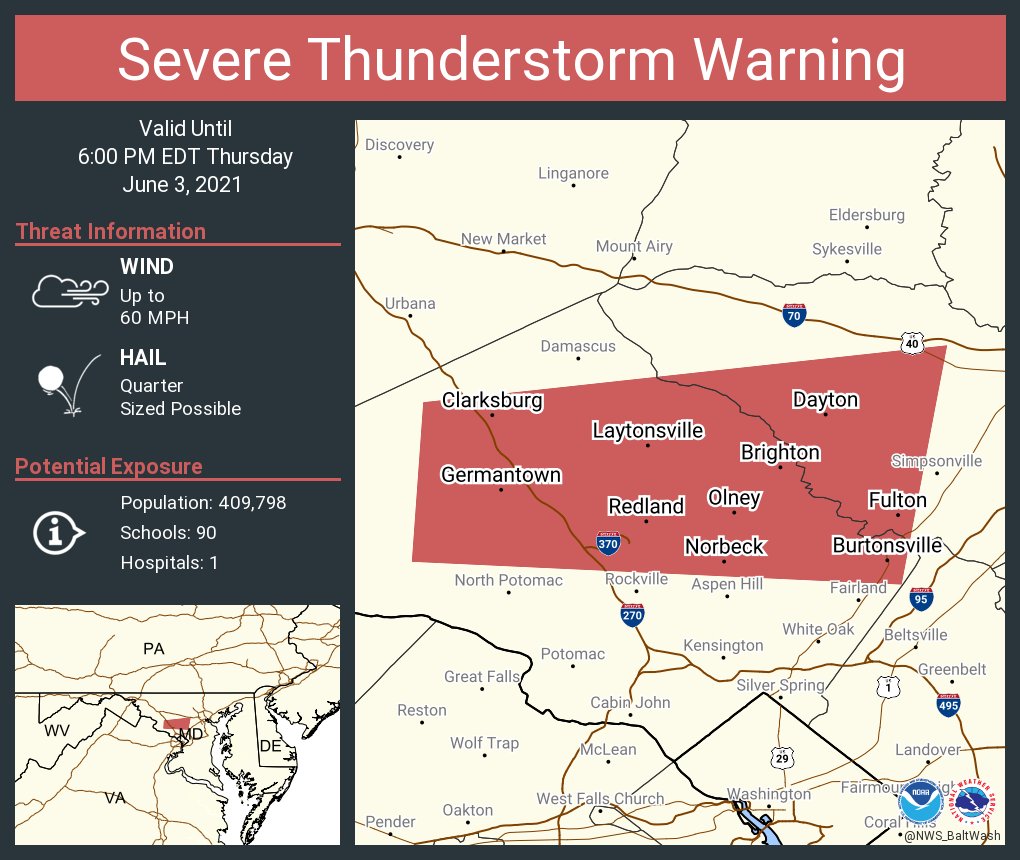
There is a severe thunderstorm warning for Germantown and Gaithersburg! Expect 60 MPH wind and quarter sized hail.

5:13 PM UPDATE:

Severe storm for parts of MoCo. Main threat are 60 MPH winds and quarter sized hail.

3:55 PM UPDATE:

Graphic for MPD #0272 

For MoCo, and eastern and northern areas, the WPC has issued a mesoscale discussion for the potential of 2-3 inches of rain through 9 PM. 

3:53 PM UPDATE:

Image

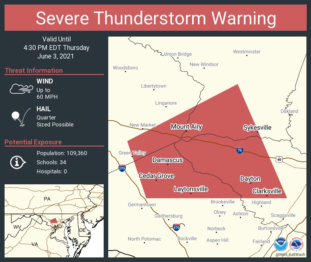
The NWS has issued a severe storm warning for Damascus. The main risk are 60 MPH wind and quarter size hail.

3:20 PM UPDATE:

Image 

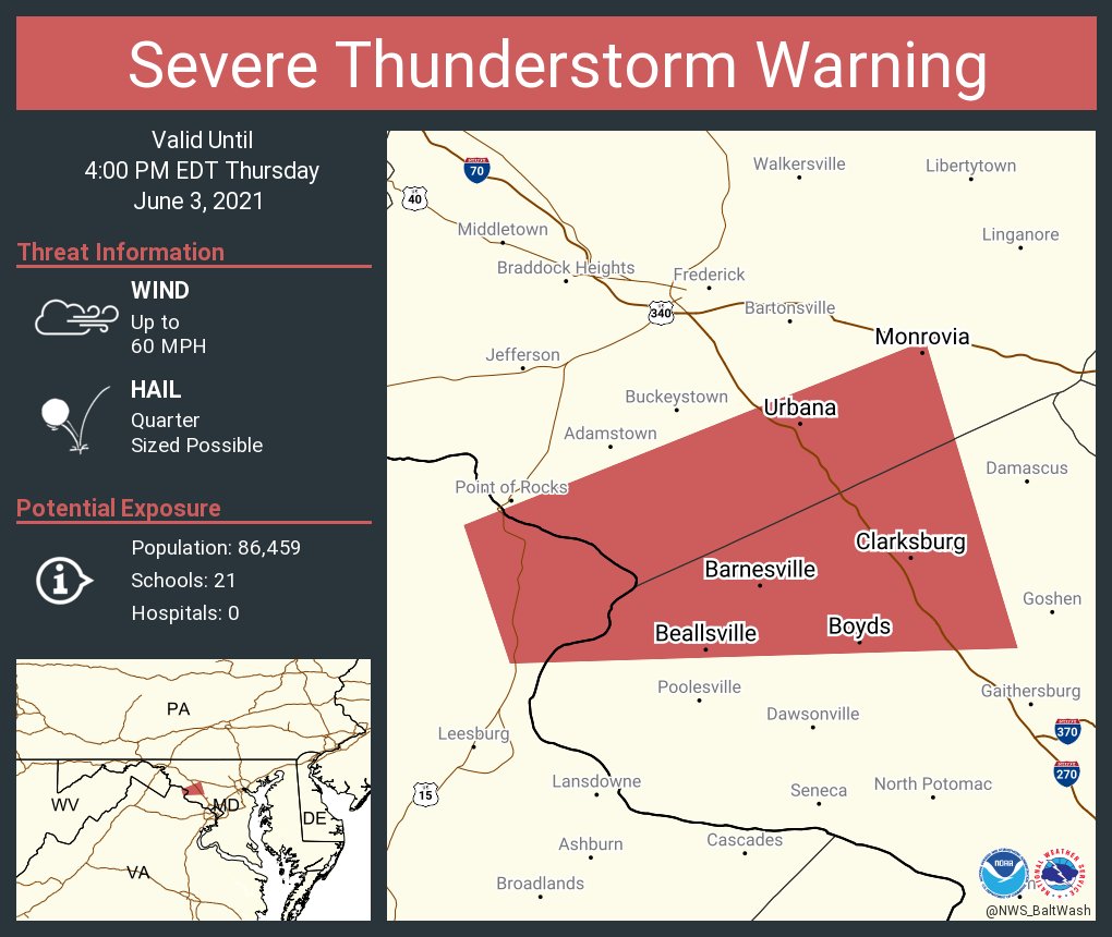
THERE IS A SEVERE THUNDERSTORM WARNING FOR CLARKSBURG, BOYDS, BEALLSVILLE, AND BARNESVILLE MARYLAND! THIS INCLUDES NORTHWESTERN MONTGOMERY COUNTY AND SOUTHERN FREDERICK COUNTY. 60 MPH WIND AND QUARTER SIZED HAIL IS POSSIBLE. SEEK SHELTER NOW!

3:15 PM UPDATE:

 
The 3:10 PM surface CAPE analysis shows 2500-3000 surface CAPE for all of MoCo and DC, and 2000-2500 elsewhere. This is more than enough to cause a severe weather outbreak, and is favorable for tornadoes to be produced.

The 3:15 PM EDT mesoscale analysis shows 1500-2000 MLCAPE for MoCo and DC, which again, is a good amount for severe weather. The shear generally remains the same, don't see too much of a difference.

2:50 PM UPDATE:

Image 

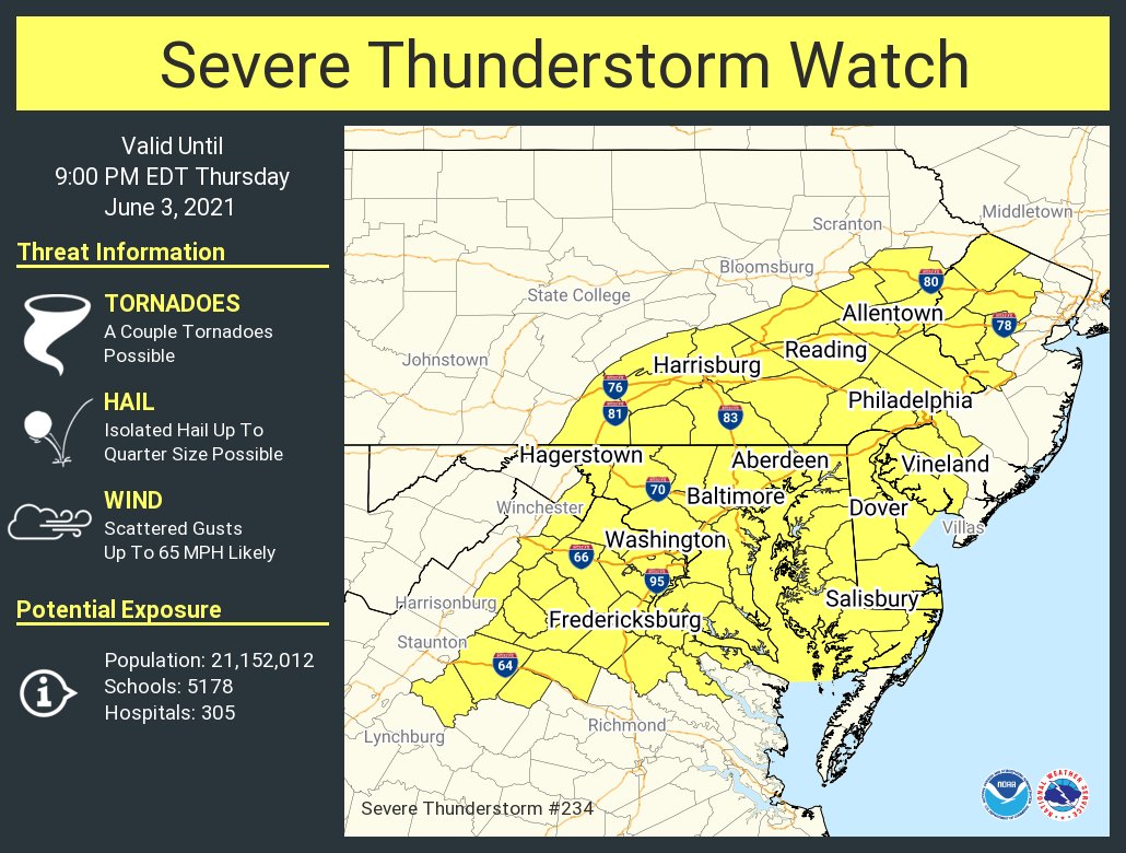
THERE IS A SEVERE THUNDERSTORM WATCH FOR ALL OF THE DMV! A COUPLE OF TORNADOES ARE POSSIBLE, AND ISOLATED HAIL UP TO 1" SIZE(QUARTER SIZE) IS POSSIBLE, AND WIND GUSTS UP TO 65 MPH IS LIKELY! 21.5 MILLION PEOPLE, 5200 SCHOOLS, AND 300 HOSPITALS ARE AFFECTED BY THIS!

2:35 PM UPDATE:

Winds are starting to shift east, slowly but surely. If winds are able to switch in time into the southeast direction, this would help tornadic activity.


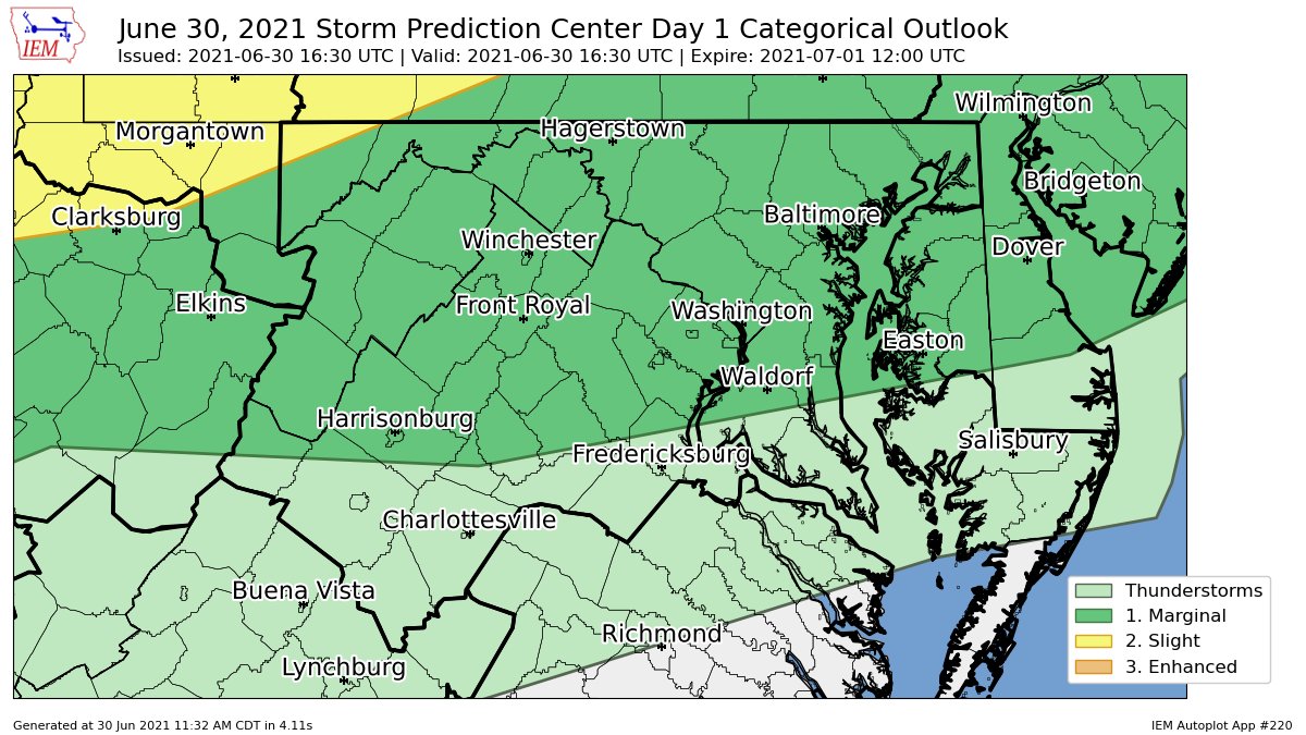
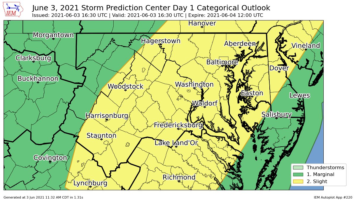
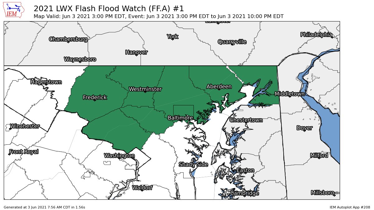
As most of you know, there is a severe weather risk today for the DMV. Not too much has changed since yesterday, and all of the DMV, including MoCo, is in a slight risk. The only major difference is that there isn't a hail risk for the northeast anymore, and the main risks are isolated tornadoes, damaging winds, and localized flash flooding. In this post, I will be looking at  2 models, the NAM 3KM and the HRRR. I will also be using mesoscale analysis from the SPC. The main timing is between 2-10 PM. MD, VA, and NC will likely have more severe weather due to the widespread clearing and higher moisture content. The SPC has us in a 2% tornado risk and a 15% wind risk.


NAM 3KM:


This is the sounding from the NAM at 4 PM EDT for Northern MoCo. It shows a critical angle of 86, which is good, and severe weather(not marginal severe). It shows 2000 MLCAPE(CAPE in atmosphere), and around 3100 CAPE at the surface. The dew point is 69, which is good as it brings moisture. Lapse rates are good, shear isn't that great, and storm relative velocity is pretty bad too. Overall, this sounding is decent for severe weather.


The NAM shows pockets of 2000+ MLCAPE(Mixed-Layer Instability) in MoCo and the DMV, and 1500-2000 MLCAPE elsewhere(generally near the pockets of 2000+ MLCAPE). This is more than enough for a severe outbreak and even tornadic activity. Jim Cantore, an official meteorologist, thinks there's a tornado risk for DC and parts of the DMV.

The NAM 3KM shows a good amount of shear in the atmosphere at 8 PM EDT. Areas in the pink are in 50-60 KT of shear, which is more than enough for a severe outbreak.

HRRR:


The HRRR(15z) shows 1000-1500 MLCAPE in the blue and 500-1000 MLCAPE in the gray. The SPC thinks that there should generally be 1000-1500 MLCAPE for areas southwest of the Mason-Dixon Line.


The HRRR shows 50-60 KT of shear in the pink areas, and 30-50 KT of shear elsewhere. This is a decent amount for a severe outbreak.


The HRRR shows a decent sounding for severe weather at 4 PM EDT. It shows around 1200 MLCAPE, 1750 surface CAPE, a good dew point, good critical angle, good lapse rates, meh shear, and an ok SRH. Overall, not too bad for severe weather.


SPC Mesoscale Analysis:


 The SPC mesoscale analysis at 1:10 PM EDT shows already a decent amount of MLCAPE. 1000-1500 MLCAPE for a lot of the region, including MoCo and DC, and a pocket of 1500-2000 MLCAPE just west of DC. In our northern areas, 500-1000 MLCAPE remains.


The SPC mesoscale analysis at 1:30 PM EDT(most unstable CAPE) shows a lot of CAPE, including 2000-3000 in areas south of Frederick. In our northern areas, 1000-2000 CAPE lies.(this is most unstable by the way, MLCAPE is more important).


The SPC mesoscale analysis at 1:14 PM EDT shows 30-40 kt of shear for most of our region. This is in the range of good shear, and supercells become more likely as this number increases(surface-6km shear).


As more updates come in, I will update this post. The timing is between 2-10 PM, main threats are isolated tornadoes and damaging winds, but flash flooding is possible, slight risk for DMV, good amount of shear and MLCAPE, and be prepared for these storms.


Flash Flood Watch for Parts of the DMV

Image
Good morning! The NWS has issued a flash flood watch for parts of our area including all of MoCo, Frederick County, Howard County, Carroll County, Baltimore and Baltimore County, Harford County, and Cecil County. This is from 3 PM EDT through the evening. Rainfall from numerous thunderstorms and showers will be around 1/2" across the region, but locally, where more thunderstorms develop, rainfall amounts could reach 2-4 inches. 

"Heavy rainfall in a short amount of time can result in rapid rises of water in streams, creeks, and urban areas. A Flash Flood Watch means that conditions may develop that lead to Flash Flooding. Flash Flooding is a very dangerous situation. You should monitor later forecasts and be prepared to take action should Flash Flood Warnings be issued." - NWS

I will make a post updating about the potential of severe weather later today! Until then, stay safe, and stay weather aware.

Wednesday, June 2, 2021

Severe Threat for the DMV Tomorrow


There is a severe weather threat for the DMV tomorrow, with the main threat being damaging winds. An isolated tornado or (large) hail cannot be ruled out though. The SPC has issued a slight risk(2/5) for most of our region. An enhanced risk(3/5) is possible tomorrow, and I wouldn't be surprised if parts of the DMV get an enhanced risk. There will be modest CAPE and a decent amount of shear. Instabillity will be able to build, even with cloud cover, due to strong warm air advection. And model soundings are also starting to suggest cloud breaks tomorrow. 


As you can see, there is a 2% chance of any tornado occuring in the green area 25 miles away from any given point.


There is a 5% chance to see 1" or larger(not the chance for less than 1" hail) 25 miles away from any given point in the green area.

There is a 15% chance in the yellow area to see winds 65 MPH or higher winds 25 miles away from a certain point, and a 5% chance in the green area to see winds 65 MPH or greater 25 miles away from a certain point.


The HRRR shows modest MLCAPE at 11 AM EDT tomorrow, with 1000-2000 MLCAPE throughout a good part of the region. When the cold front moves across, it will take all the MLCAPE with it. This is when the highest MLCAPE throughout the region is.


At 1 PM EDT tomorrow, the 18z HRRR shows 30-55 KT of shear throughout the region. This would be enough to support severe weather.

At 6 PM EDT(tomorrow), in Northern MoCo, the HRRR shows a pretty good sounding for severe weather. It has 1500 MLCAPE, and 2000 at the surface, good lapse rates, and a good LCL and EL level, plus a decent crtical angle and storm slinky. However, the shear is really bad. High dew points will help bring in moisture.

Now, let's see the NAM 3KM.


 The NAM at 4 PM EDT tomorrow shows isolated pockets of 40-65 kt of shear throughout the region, which is defintely a good amount for severe weather. The NAM 3KM wants a more aggressive solution for sure.


Unlike the HRRR, at 8 PM EDT, the NAM shows a lot of MLCAPE throughout the region, with most of the region in 1500+ MLCAPE, and some parts being all the away up to 3000 MLCAPE! This is definitely a very good amount of MLCAPE for severe weather. 


This is a sounding from the NAM 3 KM at 6 PM, and its not too shabby. It shows a tornado for Northern MoCo. The LCL is very low, good lapse rates, 2000+ MLCAPE, 2500+ surface CAPE, good crtiical angle. However, the slinky is bad, shear is meh, and SRH isnt that great either. Very good dew point though. I could see this event producing an isolated tornado.


Those are the 2 models that people generally use the most for severe weather forecasting, and they both show severe weather for our area. One is definitely more severe and aggressive than the other. The main threat is damaging winds, there will be substantial CAPE and a decent amount of shear, and you should be prepared tomorrow. There's not much else to say, so I will see you tomorrow!

Featured Post

2/17 Overnight Moderate Event for DC/Balt Metros

A low-pressure system tracking in southern VA will bring our region snow again. It will move out fast, but will bring good dynamics with it,...