Wednesday, May 26, 2021

Severe Weather Threat for all of the DMV

5:05 PM Update:

THERE IS A SEVERE THUNDERSTORM WARNING FOR MOCO, INCLUDING ONLEY AND SOUTHEASTERN MOCO. 60 MPH WIND AND PENNY SIZED HAIL IS POSSIBLE! SEEK SHELER NOW!!!


4:45 PM Update:

A lot has happened. There was a very dangerous storm hitting Fairfax which had 80 MPH winds and Golf Ball Sized hail. 
The SPC still has most of our region in the damaging wind threat.

3:25 PM Update

THERE IS A SEVERE THUNDERSTORM WARNING FOR FREDERICK, MD, ADAMSTOWN, MD, MIDDLETOWN, MD, BURKITTSVILLE, MD, JEFFERSON, MD, BRUNSWICK, MD, LOVETTSVILLE, VA, HILLSBORO, VA. 60 MPH WIND AND PENNY SIZED HAIL IS POSSIBLE! SEEK SHELTER IF YOU ARE IN THESE LOCATIONS RIGHT NOW!

3:10 PM Update:


There is a severe thunderstorm watch for all of MoCo and the DMV. Winds gusting up to 70 MPH, up to quarter-sized hail(1"), and frequent lightning strikes. 6611 schools, 391 hospitals, and 26,166,225 people are affected by this severe weather. Take this seriously!


There is a slight risk for all of the DMV and MoCo, and almost all of Maryland as you can see above. The main threat are damaging winds and quarter-sized hail, although an isolated tornado can't be ruled out. The timing of this severe weather is between 2-10 PM EDT. Temps are supposed to be very hot today. A map from the NWS shows a good amount of our region(DMV) in the 90-95 degree temperature area. Plus, with the sun out in many places, this will help increase CAPE on the ground and within the atmosphere.


As you can see, there is a 2% chance for a tornado 25 miles away from any given point in that green area.


For the hail risk, there is a 5% chance for people to see 1" or larger hail(not include <1" hail) 25 miles away from any given point.
As you can see, the damaging wind chance is higher than the other severe risks. There is a 15% chance for 65+ MPH winds for the DMV 25 miles away from any given point.

As you can see from this 16z HRRR sounding at 4 PM EDT, there is a decent critical angle and a good amount of MLCAPE(1300), which would be enough to cause severe weather. The dew point is good, and the temperature is hot. These are good conditions for severe weather. Lapse rates are also not too bad either. 

The SPC has issued a mesoscale discussion for the DMV. It states that potential for damaging winds will increase, and that a severe watch may be issued by 3 PM EDT.

As you can see, the HRRR at 4 PM EDT shows a good amount of MLCAPE throughout the region, with isolated pockets of higher MLCAPE. In those pockets, are where isolated severe weather is more likely.
At 4 PM EDT, the 16z HRRR shows some decent lift throughout the region, and where you saw isolated pockets of high(er) MLCAPE, there are also pockets of higher lapse rates. This, with the unstable air, could be enough to create updrafts and create a severe storm. At this time, there is very little shear, not anywhere near enough to be favorable for severe storms. 

Key Points:

- Timing 2-10 PM
- Main threat are damaging winds and hail, isolated tornado cant be ruled out
- Afternoon heating will allow for MLCAPE to rise to around 1000 j/kg, and isolated pockets of high CAPE plus lift and lapse rates may lead to the formation of storms
- A severe watch may be issued soon in the next couple of hours 
- Dew points around 55-70 and temperatures will rival and beat 90 in some areas


Sunday, May 9, 2021

Wintry Precipitation in May?

Yesterday, May 8th, there was a lot of reports of hail and graupel throughout the region. I saw a mix of less than pea sized hail and graupel. Graupel is wintry precipitation. Meaning that we saw some sort of wintry precipitation in early May, which is rare for our region. Pretty crazy isn't it? This is not common for our region. The cold pattern is really doing wonders here. It will also make the ground cooler and delay the boom of cicadas.

Here's a video of the hail/graupel mix that moved through the region.


Wednesday, May 5, 2021

Wednesday Severe Weather

2:00 PM:

The SPC has issued a mesoscale discussion, stating the chance for isolated damaging wind gusts this afternoon. A severe watch is unlikely, at a 20% chance.
 

There is another severe weather risk for our eastern regions. Most of MoCo is in the marginal risk for severe weather, and the main threat are damaging winds, and potentially hail. The best chance is between 11 AM - 5 PM. Our northern and western areas are in a general risk.


Areas in the green have a 5% chance of seeing 65 or higher MPH winds 25 miles away from any point.


The HRRR shows enough CAPE for an isolated severe outbreak at around 1-2 PM.  There is an ok amount of shear, nothing too crazy, and the critical angle is one of the worst for severe weather ive seen in a while. Lapse rates are nothing amazing but still decent, and there is a decent amount of lift. This is overall not that great for severe weather, and the threat would be very isolated.

Convergence along the front combined with surface heating may just be enough for a severe storm to form. Compared to yesterday, the severe threat will not be widespread and the threat is generally small.


Tuesday, May 4, 2021

Tuesday Severe Weather

4:30 PM:


There is a severe thunderstorm warning for most of Fairfax County and just west of DC. 60 MPH wind and penny sized hail is possible.

4:05 PM:

There is a severe thunderstorm warning for southern Loudoun County and Northern Fairfax county! Penny sized hail and 60 MPH wind is possible! Seek shelter inside now!

3:55 PM:

The SPC has issued a mesoscale discussion for most of our area, stating the risk for damaging winds and isolated hail that's severe.


2:00 PM:

THERE IS A SEVERE THUNDERSTORM WATCH FOR ALMOST ALL OF MARYLAND AND VA, AND ALL OF THE REGION. WIND UP TO 70 MPH, PING PONG HAIL, WHICH IS UP TO 1.5" HAIL, AND FREQUENT LIGHTNING IS POSSIBLE. THAT SIZE OF HAIL CAN MAKE YOU SERIOUSLY INJURED. THIS IS VERY DANGEROUS. PLEASE TAKE THIS SERIOUSLY! 12.5 MILLION PEOPLE ARE AFFECTED BY THIS!


As said in the previous post, there is a chance for severe weather today too. The sun is out in many places, allowing for instability to rise. Southern MoCo is in the slight risk, and Northern MoCo is in the marginal risk for severe weather. The timing is from mid-afternoon through this evening. The main threat are large hail and damaging winds, but a tornado cannot be ruled out.


As you can see, our northern and generally western areas are in the marginal risk, while southern and generally eastern areas are in the slight risk.
Most of the region is in a tornado risk, with only our far western and far northern areas in the <2% risk. In the green, is a 2% chance to see tornadoes 25 miles away from any point.
This is the hail risk for today. All of the area are in the 5% chance to see 1" or larger hail 25 miles away from any point. This does not include less than 1 inch hail.


This is why there is a slight risk for DC and Southern MoCo. There is a 15% chance in the yellow to see 65 or higher MPH winds from thunderstorms 25 miles away from any given point, while a 5% to see the same thing in the green.


The SPC has issued a mesoscale discussion for the following area, stating strong to severe storms bringing up a significant wind threat. In that area, there is an 80% chance of a severe storm watch being issued.

The 12z HRRR, at 4 PM EDT, shows 500-1000 MLCAPE across the region, with a little bit more in some regions. This amount would be enough to cause some storms to form.
The lift is between -2 C and - 5 C throughout the region. This will be enough to cause some storms to form.

There isn't much shear in the atmosphere at this time, but lets look at a sounding.

This sounding isn't favorable for tornadoes. There are decent CAPE and lapse rates, but bad shear. Dew point is good though.

I will update this post whenever something happens.


Monday, May 3, 2021

Monday Severe Weather Update and Nowcast

10:05 PM:

As you have seen, there has been many tornadoes today in Maryland. An isolated tornado was possible, and I wasn't too surprised when I saw the first warning go up, but there was way more than expected. And it was mainly in the areas where there wasn't even a marginal risk; just a general risk. This event was much worse than expected. And, this event is far from over. The event will last into Tuesday. There still is a threat for isolated tornadoes. You should be prepared to shelter in the night and have ways to get severe/tornado alerts. A weather radio will come in handy. Be prepared. It will hopefully get better. But you never know, since today's tornadoes in the TSTM risk and the sheer amount of them were unexpected.

9:30 PM:

Tornado warning for baltimore county. Seek shelter if you are there.

9:00 PM:


Tornado warning for Westminster and Hampstead, MD. Seek shelter now!

8:55 PM:


SVR TStorm warning for Mount Airy. Wind up to 60 MPH, penny sized hail, and a tornado is possible


8:35 PM:


Tornado warning for Carroll County... seek shelter now.

8:20 PM:

THE TORNADO WARNING HAS BEEN EXTENDED UNTIL 8:45 PM. IT HAS BEEN CONFIRMED. THIS IS A LIFE THREATENING EMERGENCY! TAKE COVER NOW! TREES WILL LIKELY BE DAMAGED, DAMAGE TO ROOFS, SIDING, WINDOWS, ARE POSSIBLE, AND MOBILE HOMES MIGHT BE BADLY DAMAGED OR COMPLETELY DESTROYED. FLYING DEBRIS MAY BE DEADLY TO THOSE IN THE WARNING! PLEASE TAKE THIS SERIOUSLY!

7:45 PM:

There is a rain wrapped tornado for Frederick, Discovery, Libertytown, and Linganore Maryland. GET INSIDE AND SEEK SHELTER NOW!!

7:10 PM:

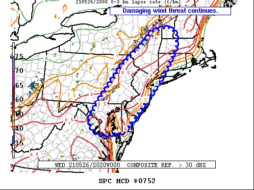
The SPC has issued a mesoscale discussion for our area, stating the chance for an isolated threat for damaging winds and a brief tornado in the next few hours. A weather watch is unlikely though.

7:00 PM:

There have been multiple tornado warnings and severe t storms throughout the region, I wasn't able to cover them because I was on a walk. I will try to cover them now.

5:40 PM
There is a severe thunderstorm warning for Lake Holiday, VA. A tornado is possible, and wind up to 60 mph and penny sized hail can be expected.


There is a severe weather risk for tomorrow, and not much has really changed. Most of the areas who are in the marginal risk are near or south of I-70. The main threat is damaging winds, heavy downpours, and small hail. Isolated flooding is possible with these thunderstorms due to heavy downpours and rainfall. The timing is mainly from 2 PM - 12 AM Tuesday.

As you can see, most of the region is under a marginal risk. The main threat is damaging winds.

The SPC gives us a 5% chance to see damaging(55+ mph) winds 25 miles away from any given point.


The 16z HRRR run shows around 1000 MLCAPE throughout the region(around 6 PM EDT), with some areas a bit over 1000 MLCAPE (MoCo is in the 700-1000 MLCAPE range). The NWS forecasters discussion for our area states an instability at around 1000 CAPE later today. Some breaks of sun will occur throughout the region today, allowing instability to build.

The 16z HRRR(6 PM EDT) shows around 35-55 KT of shear in the atmosphere for a good chunk of the region, with MoCo in the 40-55 KT shear area. This will be enough to cause some damaging winds. The NWS forecasters discussion for our area states 40-45 KT of vertical shear, which would be enough to cause strong tstorms to become severe locally.


This is the 16z HRRR in MoCo at 6 PM EDT. Although today is mainly a wind threat, some tornadoes are not out of the question at all. This sounding shows a good amount of shear at 500mb, with good LCL placement and a good amount of CAPE(1000). The SigTor parameter is around 1, meaning that this tornado is around an EF0. The storm slinky is a "C" shape, which is decent for tornadoes, and the critical angle is not bad either. In hours(3 PM EDT onwards) before this, they show marginal severe weather, and even after 6 PM EDT, it still shows severe weather for us. As said before, the main threat is damaging winds, so I assume for most of the "marginal severe hazards" on the HRRR soundings will be for strong winds and maybe small hail.

There is another severe threat on Wednesday, and I think that has much more potential than this one. Some models are showing a lot of CAPE in the atmosphere. I will make a post tomorrow about it. I will update this post whenever something new happens(nowcast).


Sunday, May 2, 2021

First Significant Severe Threat This Year For the DMV Tomorrow Night - Tuesday Afternoon

There is a severe weather risk for tomorrow for the western and southern parts of our region, and it may be the first real significant outbreak in the DMV. Tomorrow is mainly a wind and hail threat, but there is a tornado threat too. Most of our region is in the marginal risk, and the rest are in the general risk. I'm pretty sure that this risk will be upgraded to a slight at the very least; maybe an enhanced tomorrow.


This is the risk for tomorrow. The main risk is during Monday afternoon - Tuesday afternoon. Almost all of MoCo is in the marginal risk area, and the rest of the region is in the general risk. I assume that everyone in the general risk will be upgraded to have a severe risk, and marginal at the very least.


This is the wind risk for our region. There is a 5% chance of areas in the green to see 65 or higher MPH winds 25 miles away from any given point. These are winds from thunderstorms, not anything else.
This is the hail risk for our region. There is a 5% chance for areas located in the green to see 1" or larger hail 25 miles away from a certain point. This does not include the chances for <1" hail.


This is the risk for tornadoes in our area. Not all areas in the marginal risk are in the tornado risk. Areas in the green have a 2% chance of seeing any type of tornado 25 miles away from any given point. 


This is the 18z HRRR for hour 48, 8 AM EDT Tuesday. It shows 1000-1500 ML CAPE for our county, with up to 2500 MLCAPE in our western regions(yellow), with 500-1000 MLCAPE for our eastern regions(gray). This is a pretty good amount of MLCAPE to work with.
There is a REALLY good amount of lift here. Our county is between -5 to -7 C of lift, and our western regions go up to -11 C of lift! Eastern regions have -4 to -6 C of lift. This is a really good amount!

However, there barely isn't enough shear to support severe weather(25-30kt, you want over 30kt for severe weather). This time, eastern regions have more shear, some regions over 30kt, while western regions have less than 20kt of shear. There still is something though, and we have instability and lift, plus very good dew points (this is hour 48 of 18z HRRR). 

Although this threat is mainly a hail and wind one, there is also a chance for some isolated tornadoes. Check out this NAM 3KM 18z sounding!

This is a pretty good sounding for tornadoes(Gaithersburg MD)! The critical angle is really good, the significant tornado parameter is at 2, suggesting an EF1 or EF0 tornado; possibly low-end EF2. The LCL is pretty low, over 1000 MLCAPE, and good dew point and temperature.

Do I think we will see an EF2 tornado or stronger in our region? No, at least not right now. We will know more tomorrow afternoon after observing data and soundings. Isolated tornadoes are definitely possible though. We will just have to see. I'll make an update tomorrow. Don't get too worried over the chances for severe weather; just be prepared and tell others. It can be dangerous and devastating, but as long as you are prepared, it won't be too bad, and that's all you can do to protect yourself. This not only goes for this specific event, but just severe weather events in general. At the same time, don't get too relaxed. Check the latest forecast on the NWS website so that you know when and if events occur. If you see a tornado or severe thunderstorm warning for your location, get inside and seek shelter! Even if you don't see it, still take shelter! The tornado can be rain-wrapped, meaning that it's very difficult to see, and the storm could be very dangerous, but it hasn't reached you yet. Just be careful, stay safe, be prepared, don't be too anxious, and I will see you tomorrow in the next post!

*Edited by QuackyDucc


Featured Post

2/17 Overnight Moderate Event for DC/Balt Metros

A low-pressure system tracking in southern VA will bring our region snow again. It will move out fast, but will bring good dynamics with it,...