Showing posts with label Winter Storm Watch. Show all posts

Saturday, January 15, 2022

MLK Weekend Storm - What to expect

Good afternoon everyone! We have a winter storm threat to track tomorrow and Monday morning. This threat is looking more like an ice threat instead of a snow threat; but if you live north and west of I-95 you will still see some snow accumulation for this storm. Unless you're far north and west(along and west of I-81), you probably won't see an optimal amount of snow - if you like snow. This storm takes an inland track - so being even a little bit more west can make a difference. When the snow starts, it will be heavy, with rates 1-3" per hour. When it snows, it will thump. Wind gusts up to 45 MPH are possible with this storm, creating the possibility of downed trees and spotty power outages, especially when ice starts to take over the snow. I would recommend to stay off of the roads(if NW of I-95) on Sunday-Monday, as the snow with ice makes roads very slippery and impassible at times. There is a very cold airmass in place for the storm, so ice and snow will stick longer to untreated surfaces. Please note that freezing rain can happen even above freezing, if surface temps and wet bulb are still <32. There is a winter weather advisory for all of MoCo, with 1-3" expected and up to 0.1" of ice. Just north of us is in a winter storm warning, for 2-4" of snow and 0.1-0.3" of ice.


NAM12KM:


Note: at the time where it shows pink for our area(7 PM), I looked at a sounding for Germantown/Gaithersburg and it would seem as if it would be sleet, rather than freezing rain. Still, you can see everyone starts off as snow, and then the warm nose comes in, turning into sleet, then freezing rain, and eventually, when the CAD breaks, cold rain. 


Ice total and snow total maps, pretty self explanatory.


NAM3KM:


The NAM high res shows everyone starting out as snow, then going to ice, and then going to plain rain. The NAM 3KM also shows some backend snow, which is interesting. However, it seems to be light snow, and probably wouldn't amount to much. A lot of the rain will wash all of the snow away, so even if 3" fell, it wouldn't look like it.


The reason why the NAM 3km shows a lot of ice is because of strong southeasterly upper level winds, forcing warm air into the atmosphere and creating a warm nose that gets more dense as time goes on. Eventually, the cold air at the surface breaks, and areas east of I-81 switch to cold rain.


 One other thing I want to talk about is the wind gusts. At this time(8P Sunday), freezing rain is falling all throughout the region. With the strong wind gusts(40-50 MPH wind gusts), isolated power outages and downed trees is likely. I would recommend everyone north and west of I-95 to get ready to deal with some time w/o power, just in case.

*Editors Note: While I was writing this, the 18z NAMs came out, all of the models shown are from the 12z suite

My snow and ice forecast:

(I apologize for very low quality maps, Blogger won't let me put high quality pictures) 


My next update for these maps will be tomorrow morning, after 12z mesoscale runs come in. I'm going bullish with my forecast because I think there will be heavy enough rates for a large enough area to get 2-4" before the changeover to sleet, freezing rain, and then cold rain. I think the NAM is too bullish on the warm air coming in very quickly and changing over to rain, so I didn't use the NAM that much in my forecast. Other models look pretty good for our region in terms of snow, such as the Euro, GFS, and HRRR. My final call WILL be tomorrow morning, after 12z HRRR, and both NAMs come in.

To conclude, I expect 2-4" of snow(possibly more in localized areas) for Northern MoCo and 1-3" for Southern MoCo. For ice, I expect 0.1-0.25" of ice for the general area, with possibly more in localized areas. Timing onset will be in the afternoon, at 1-3 PM. This will be a high impact storm, especially west of I-81, and also for NW of I-95, not just for snow, but for ice. I am very concerned about the ice threat, since CAD is usually undermodeled, especially on global models, and the ice combined with the strong wind gusts could create widespread power outages and downed trees. I'll have a quick update tomorrow, and then I'll do a nowcast.


Sunday, January 2, 2022

First Significant Snowfall of the Season

 Update: All schools in MoCo have closed for tomorrow
I have a Twitter account, follow for more weather related news: https://twitter.com/shark_wx
 
Overnight, models have trended towards the better for snow lovers. The model runs have only been getting better and better for snow. All of the models have either trended NW, or stayed in the same place. Also, every model has been trending more amped(powerful), and reserved(slower), which means that when we get snow, its gonna be dumped on us. The storm on radar also looks more amped and NW compared to what the models were showing, which is very good. Southern MoCo is in a WSW(3-7" expected), and Northern MoCo is in a WWA(2-4" expected). Near blizzard conditions are possible with this storm. If NW trend continues, Northern MoCo will be in the WSW too. Snow rates between 5a - 11a tomorrow are the heaviest, with rates being 1-3", and with <32 temps, it will not take long for the morning commute to descend into chaos. I'll be making my snowflake prediction for school closings, and my snow forecast!

Euro:

 Euro shows 8-10" of snow for MoCo, and it's solution is similar to the 21z RAP.z


The Euro ensemble has >90% for almost all of MoCo to see 3+ inches of snow. The extreme northern part of MoCo has a 80-90% chance, which is still VERY high.

SREF:

This is the SREF mean. It shows 6-12 inches for MoCo and south. At the start of the storm, it will take a while for the ground to cool, but oh it will cool very fast once it really starts to snow. This isn't kuchera, so it will be inaccurate. At the start, snow ratio will be less than 10:1, but when the heavy snow starts to pick up, and temps start to drop, the ratio will be more than 10:1. Overall, the SREF mean shows a significant snowfall for our area. 


NAM:


(Credit: to dollar monkey#6663 for telling me this)

I don't trust the snow amounts and the ptype map on the NAM, but my friend saw something on vorticity that was really interesting. The area that was circled could potentially have a heavy snow band in that area, which would increase totals. Bands always form north of what is modeled, and this one looks to do just that. There is a tail at 700 mb vorticity, and that usually means that north of it gets a heavy snow band. Hence, I think that a heavy snow band will form in this area. The first image is an alternative scenario where the band sets up further south, and the third image is a scenario where it sets up further north. I have a more confidence for the third image(FGEN at 700mb supports this, second image), and the band will set up in the DC metro region. This was something interesting I found on the NAM 12km.


GRAF:


This is the GRAF model. I don't have access to this model, but I was able to find it online. It shows 6-12 inches for almost all of our region, including extreme southern Frederick county and south of that. It shows 12-18" of snow for parts of eastern MD and DE, which might be a little too extreme. I am not sure how well this model does, but I heard that it does really good with these types of events. This shows a widespread significant snowstorm for the DMV.

RAP: 


This is the RAP. It shows a widespread 6-12", with SoMD getting the highest totals. MoCo gets 8-10" of snow, which is a VERY substantial amount. I would say that this wouldn't be as extreme, but the storm as of 5:52 PM looks much more stronger and amped on radar, with more moisture, so this could indeed verify.

My Snow Forecast:


This is my second call for snowfall for the January 3rd event! It's pretty self explanatory what the totals are, so I'll go over why I made it like this. I feel like this storm will over perform. On radar right now, the storm is more north, and is much more amped than high-res models were showing, which is a very good sign for this storm to boom. I was talking about the possible location on where the heavy band sets up, and that would increase snow totals significantly due to a good thump. Because of models overall trending for the better, and the observed storm is doing better than what was expected, I made the snow totals more widespread and increased them. DC and south is going to receive 6-12" in my opinion because of the heavy thump of snow and possible banding forming there. I think 5-9"+ for central and semi-northern MD(MoCo) because of the storm going a tad bit north with much more moisture. There is a possibility that the 5-9 area could see more than 9 in localized spots because of heavy banding moving north. Snow rates will be extremely heavy with this storm, and will overtake ground temperatures quickly. It will start off as rain before quickly turning into snow.


As for the snowflake prediction: 4.5 Snowflakes


I am very confident in schools closing for this system. 1-3" rate snowfall during the rush hour is a recipe for disaster. Crew won't have enough time to fully treat the roads, and the initial rain will wash off some of the salt and make it less effective. Winds are also going to be very gusty, further creating a visibility problem. I just cannot see how schools will open, even on a 2 hour delay.


Thursday, March 4, 2021

NWS Announces That Special Weather Statements and Advisories Won't Be Used Again by 2024

 The National Weather Service today announced that advisories for weather events like wind, flooding, and winter weather will not be used again(exception: Tsunami and Small Craft Advisories), and this also includes special weather statements. This is some really big news to hear since this will change the way weather forecasters predict and the whole system of the NWS forever. In this post, I will be going over:

- Why this is happening

- What will be happening in the future

- My opinion

You can also read the whole document that the NWS made at:

https://www.weather.gov/media/notification/pdf2/pns21-12_haz_simp_headlines.pdf

Why This is Happening:

But why is this happening in the first place? Well, it's because research done by the NWS shows that Advisory headlines cause confusion within the general public, who don't understand the weather alert system that well. The term itself is often misunderstood and is often compared to a Watch(meaning that dangerous weather may be happening soon). This misunderstanding can lead to confusion of the forecast and may hinder the preparation of people trying to get ready for the weather, usually for the worse. The NWS wants to make it more obvious about the weather hazard and wants people to have less confusion and misunderstanding.

What Will Be Happening In the Future:

All of the advisory headlines that are in the NWS' "Watch, Warning, and Advisory" system will be discontinued. Most of them will be replaced with "plain-language headlines" that will be made in an effort to clearly announce and state the nature of the hazard. They will still have the "Valid Time Event Code" (VTEC) as we do right now. All special weather statements will be discontinued, however, they will have a computer-readable VTEC and will be placed in a "What, Where, When, Impacts" type of format. The exact language used in those headlines is yet to be determined but will be determined in the next couple of years. Everything else would be either watches or warnings. Some advisory-level events might become warning or watch criteria. For example, 4-5 inches of snow(still technically advisory level right now) could become a winter storm warning once these changes are implemented.

My Opinion:

My opinion about this decision is that it's good, but I don't agree with implementing this everywhere. Why? First of all, we have been using this system for a very long time; maybe even since the NWS was founded! It is going to take a long time for everyone to get adapted to this whole system, and this will create more confusion. And my worry is that with these "plain-language headlines" that people will have even more confusion! There is already a lot of confusion between watch and warning, and I feel like removing advisories would cause a little bit more confusion. Since I don't have much experience forecasting weather that isn't winter-related, I am not sure how it will work with other weather, but I have enough information about winter weather to make an educated opinion. Winter weather advisories should be there in the DMV. Maybe not for areas like New England and the Midwest, but since our winter-weather events are generally on the smaller side, we should still have advisories, because like I said, people will take it less seriously if there isn't one. I agree with the decision to remove special weather statements though, they don't really do much. Overall, I think it is a good decision, but some changes need to be done to it.

I will be giving more updates to this decision as I get more information. And I know, I haven't been posting too much recently, because of the boring weather pattern. However, winter is not over until its really over. Models are showing an interesting pattern for mid-March. I will make a post on Saturday/Sunday explaining it when I have more details and information. I told everyone that in La Nina winters, something usually comes up in March, even if that winter so far was bad. And well... there you have it! Something came up! Winter isn't over until its TRULY over. Don't throw away the thick, winter coat just yet. The weather will be really nice next week, and some areas could get into the 70's!

Tuesday, February 16, 2021

Thursday-Friday Storm Update and First Snowflake Prediction

The afternoon and evening models have all been trending better for snow lovers. This storm has the potential to be the biggest storm since Jan 31- Feb 3 for people who didn't get that much from it. Winter storm watches are in effect for 5+ inches of snow and 0.25+  inches of ice possible, for the entire county. This is looking like a snow-to-mix event. Temps should be below freezing the entire time, so as of now, we shouldn't be seeing regular rain. However, model trends suggest a possible switch back to snow, and even an all snow event. In this article, we will be looking at models and first-call maps.

NAM 12km (Short-Range Model):

The NAM shows us starting as heavy snow, then shows us turning into a heavy mix(sleet) before the storm is done. Now, let me tell you why this would be wrong. You see that 1034mb high over New England(interior northeast)? A warm nose with that strong of a high wouldn't be able to push in that north and west of the I-95 Corridor. And this model does have a warm bias and is an outlier. Although it usually performs well, unless other models start trending this way, I don't really buy this.

This model shows a sad 1-8 inches of snow. There is a sharp gradient in upper Northern MoCo, with the border getting close to 5-8, and elsewhere 2-5 inches(in northern MoCo). Everywhere else is along 1-3 inches. Again, the NAM is really bad with its warm nose.
European Model:


The European model shows an all snow event for Northern MoCo. For southern MoCo, it shows some mixing(freezing rain) occurring from 1-5 PM Thursday, before transitioning into all snow. It shows the snow getting out of here around 7a Friday. Although I think this is going well with this system, it might be under modeling the WAA(warm air advection) above, which would give us more mixing and ice than snow, but CAD keeps the precipitation wintry. Let's look at some snow maps.
The European model shows 6-9 inches of snow, with more snow Northern MoCo. And this is assuming a 10:1 ratio, snow ratios will likely be higher, bumping up totals to possibly 7-10 inches.

GFS:
The GFS is a snow lover's dream. It shows very heavy snow rates before turning over into sleet and then into freezing rain. It has ticked south... again. Nice to know that it corrected itself.


The GFS shows, and I have been wanting to say this for a long time, over a FOOT of snow in the border of MoCo/Frederick County! 8-13 inches, with more snow north and west than south and east. It overdid the totals, but this is very encouraging.


CMC:


The CMC has shifted south as well, giving us more snow. It shows all snow for northern MoCo and even the northern section for Southern MoCo. It shows some mixing in interior Southern MoCo, but no rain. It changes to all snow for everyone before moving out.

The CMC shows a good 8-12 inches of snow when this storm is done. And this is only a 10:1 ratio, temps will likely be colder, meaning higher ratios, meaning more snow. I think it does put too much snow on the ground but we will see...


Capital Weather Gang:

The CWG shows 3-6 inches for most of the county, and 2-4 inches for Southern MoCo. In the 3-6 inches range, a boom with be up to 10 inches and a bust in that section will be 1-3 inches. In the 2-4 inches of snow range, a boom would be up to 8 inches, and a bust would be less than 2 inches.


WUSA 9:


WUSA 9 shows 3-6 for most of the county(2/3), and 1/3 of the county(southern) is in the 2-4 inches of snow range. They think that delays and cancellations, plus snow covered roads are extremely likely, and power outages and downed trees are possible.

Fox 5:

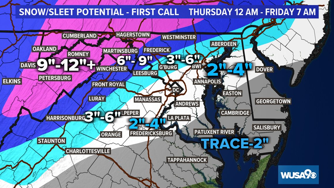
Almost the entire county is in the 3-6 inches of snow range, with the northern border in the 6-12 inches of snow range. They are going conserative with their snow totals, understandably.

ABC 7 didn't release a map.

NBC 4:
NBC 4 thinks 2-6 inches for most of the county, and 6-10 inches for the upper cap of MoCo. They think that significant icing is likely across the blue and light blue area.

NWS:

Snow Accumulation:


Expected:
The NWS shows 4-6 inches for the entire county. Somehow, DC is in that range too, which is... unlikely, because of the snowhole, but we will see. They will somehow manage to measure an inch or two even if the entire region around it gets 10 inches...

Low-End(Bust Scenario):

This would be devastating, but honestly, as much as I hate to admit it, there is a pretty good chance of this playing out. It shows 1-3 inches of snow, with 2-3 inches for half of the county, and 1-2 in the rest(scattered snow amounts)

High-End(Boom Scenario):
The NWS shows 6-8 inches of snow for the entire county. This is a snow lover's hope; one can dream!

Ice Accumulation:


The NWS shows 0.10-0.25 inches of ice for the whole county, even upcounty. Totals would be closer to the high-end of the range in Southern MoCo. This is enough to cause major disruptions, and with the snow and sleet... it won't be pretty to say the least. Widespread tree damage, and spotty, possibly widespread, power outages will occur.


Snowflake Prediction: 4 Snowflakes ❆❆❆❆

Virtual Instruction Version: 75% chance of offices closing, and almost 100% chance of school buildings closing. 

I think that there will be no school, even no virtual instruction, on Thursday. MCPS has already canceled food distribution for Thursday, suggesting that school buildings will close. I think offices will close as well, due to the heavy snow that will fall, and the significant icing, especially in southern MoCo. Temps should remain below freezing the entire time in the entire county, so there will be no hope of some melting. It's also going to be very cold on Wednesday and today night, with wind chills in the teens and possibly lower. If there is less snow, there will be more ice. And forget in-person offices, if there is a lot of ice, tree damage and possibly widespread power outages will occur. The ice will be on top of the snow as well, causing more havoc. Snow ratios will probably be greater than 10:1 as well. We will see backend snow from this storm as well. My first prediction in snow totals will be 4-8 inches across the county, with 3-6 inches in Southern MoCo, and 4-8+ in Northern MoCo(notice that plus, it means higher amounts possible). My first ice accumulation forecast would be 0.1-0.25 inches of ice for Northern MoCo, and 0.2-0.5 inches of ice in Southern MoCo. Snow will start to move in the night hours of Wednesday, and the precipitation(snow most likely) will move out around Thursday night. Snow is possible into Friday, but everything should be done by Friday afternoon. The bulk of the snow and precipitation will fall between 7a - 9p Thursday. This will be highly dangerous, and will be life-threatening, not only because of the snow, but because of the ice. The ice is the main concern for Southern MoCo, but the snow will also be a big concern. I hope that we see more snow than ice, and I think even the people who don't like snow that much can hope for that too. Do not travel on Thursday; it will be extremely dangerous and life-threatening, and will be impossible at times. Power outages and tree damage is likely. Be prepared for outages. I will have an update when tomorrow's afternoon models come in. 


Thursday, February 11, 2021

Saturday Storm Update and Some Other Storm News

 Well, snow lovers love a good snowstorm. Others hate it. But, the type of storm coming up on Saturday is something both snow lovers and snow haters hate: an ice storm. Sure, a little bit of freezing rain that causes a glaze on surfaces is pretty, and not much is done. But once you get over a quarter inch, that's where instead of looking pretty, it becomes devastating and catastrophic, with injuries and even sometimes fatalities occurring. We have 3 storm threats in the next week or so. The first one is on Saturday. The second one is on Monday to Tuesday(may linger onto Wednesday) and the third one is on Friday to Saturday. Thankfully(I say that because it's ice, not snow), this storm does seems to have less moisture than the next 2 ones. However, as it stands, the next two ones look like ice storms too. And just to show you how active this pattern is, let me show you something.


Well, there's something you don't see everyday! Winter storm threats for the northern regions for the entire time period the NWS' "Winter Storm Threat" covers! I have literally never seen this before. This is insane! There is an enhanced threat for the entire region I forecast for, on Saturday(high confidence, "low" impact). A lot can change though. Besides the crazy pattern that can easily be compared to the historical, record-breaking(in terms of snowfall) winter of 2009-2010, let's focus on our first threat: Saturday. Watches have been issued JUST south of us for Saturday's threat. I assume they will be extended northwest soon enough. You know it's a little bit wacky when D.C is the most northern zone in a watch; or any alert for that matter!

European Model:


The European model shows moderate-heavy freezing rain falling the whole time this storm, with rain far south of our county and snow far north of the county. It doesn't show any sleet either. It shows the system starting on Saturday evening/night and shows it getting out of here by Sunday.


Now, the European model has been very bullish with the ice, showing over a HALF inch for the entire county(image courtesy of Justin Weather) Once there is over a half-inch of ice, widespread power outages occur, and severe tree and power line damage is done. Not to mention travel is literally impossible. Although this is a lot, even half of this would cause major issues. The European does not seem to be backing off. Temps will be much below freezing on the ground the entire time, so any ice should accumulate.

GFS:

The GFS mainly shows scattered freezing rain showers instead of an ice storm. It shows them lasting from late Saturday night and shows them stopping after very early Monday morning(1-3 AM Monday).


The GFS shows much less ice than the European model, with only 0.05 to 0.15 inches of ice(Phew!). This will still cause disruptions though.

CMC:


The CMC shows the storm starting as an icy mix(sleet and freezing rain) before turning over to heavy freezing rain and then eventually going off to the ocean. More sleet would lessen the impacts of this storm, as sleet is less disruptive than freezing rain.

The CMC shows 0.3 inches - 0.5 inches of total accumulated precipitation. If most of this is ice, we could have a pretty disruptive problem on our hands.


Temps on the ground will be below freezing the entire time. Plus with the snowpack we have right now, ice will accumulate on any untreated surface, and will wash away pre-treatments if not put out regularly. This freezing rain shouldn't melt completely once the storm is done, it should be staying here for a while.  I won't be showing the other storms until this storm is done. Why? This storm will set up the next storm from Tuesday to Wednesday. And the Tuesday to Wednesday storm WILL set up the next Friday - Saturday storm. And besides, we are very far out. I don't think it's a good time to talk about them, because they will be changing rapidly. They could be major winter storms for us(the storms next week). They should be either snow or ice due to an arctic high and cold air in place. The latest storm(this Saturday) does seem to be trending towards being weaker, which is good. After the next 2 weeks, winter does seem to be weakening its grip a bit(we could still see some good snow after the next 2 weeks). Travel will be very dicey and difficult; impossible at times on Saturday evening - Sunday. Please avoid any unneeded travel unless absolutely necessary, and make sure to stay slow and careful on the roads; don't make any sudden movements or breaking. What appears to be wet surfaces is most likely ice. I will release another call tomorrow and my final call on Saturday.


Friday, February 5, 2021

Superbowl Sunday Storm Update

 As I said earlier, the models are trending northwest. And it's not done yet. We are now about 2 days out from this storm. But as you saw earlier last week, even when we get close to the storm, the models can still can be all over the place with disagreement left and right. This storm will be quite short, starting in the early morning hours, and will move out around the afternoon-evening hours, but heavy snowfall rates will make up for the short duration. Winter storm watches have been issued for the entire county, including surrounding counties, which starts at 9 PM tomorrow and ends at 3 PM Sunday. As it is looking right now, southern Maryland seems to be getting the most snow out of this event. We will start looking at snow totals from models, since we are not that far out. 

GFS:


The GFS shows the storm starting as light snow at around midnight Sunday, then shows it ending around the afternoon hours. Although this storm is short, it shows heavy snowfall rates to compensate for it.


The GFS shows 3-4 inches for the entire county and 3-6 inches for the general DMV. Although I do agree with this map, I also think that if we get really heavy bands, our county can possibly push over 6 inches. Surface temps + temps in the air are marginal, which means hovering at or above freezing. Even with that being said, there seems to be not much mixing with this event. If it's snowing fast though, it can cool down surfaces enough to become cold enough to support snow. We will see tomorrow's runs and decide.


European Model:

The European model shows the storm starting as moderate-heavy snow around Sunday morning, then shows it tapering off in the afternoon hours. It does show a little bit of mixing in southern MoCo, but I don't think that's the case, since upper air temperatures remain below the freezing mark. It has moved northwest(just like the other models) for this storm.

The European model shows 3-5 inches of snow for our county, lower totals in Northern MoCo, higher totals in Southern MoCo. The trend is shifting north for us, so I wouldn't be surprised if it changes so that Northern sees more than Southern. 


NAM(12km):


The NAM shows the storm starting out as rain, but then turning over into all, heavy snow. The rain will cool the atmosphere enough to support snow, so thats good if it happens. It shows the storm starting at around midnight and shows the storm ending by the evening hours. Now, if this went right, this could dump a lot of snow on us. The next image below shows high, unrealistic(at this point totals). The NAM does have a wet, snowier bias, so keep that in mind.


The NAM shows 6-8 inches of snow in MoCo alone! Now, would I love to see these totals? Yes. But do I think its realistic? Possibly. I don't think we will see totals that high, but once tomorrow comes and we have more information, we will have a better idea of what to expect.


MAPS:

Capital Weather Gang:


The Capital Weather Gang shows 1-3 inches of snow for the entire county. However, they did state that based on the model trends, their revisions are more likely to go upward(more snow) than downward(less snow). For the first call, it is good to stay conservative, and I understand why they have generally low totals.

National Weather Service:

The NWS usually goes conservative with their maps at first, but this is looking pretty good compared to other maps. It shows 4-6 inches for the upper third of the county and 3-4 inches for the rest. Overall, a range of 3-6 inches. I agree with the map the most, however, I am not sure if the upper side of the county will get more than the southern side, since that is what models are showing right now, but we will see.
WUSA 9:

WUSA 9 shows almost all of our county in the 2-4+(plus means higher amounts possible) inches of snow range, with a small sliver of northern MoCo in the 1-3 inches of snow range. 

Fox 5:

Fox 5 shows 3-5 inches of snow for our entire county(sorry for the bad quality). I actually think this is one of the best maps because they are really factoring that north trend and going somewhat confident with their totals, and where they reach.

(I couldn't find ABC 7's and NBC 4's maps, I will be including them plus another map tomorrow)

So how much of an impact will this have? Not much, but the morning commute on Sunday could be difficult. This is wet, heavy snow, but since temps(including surface) are marginal, snow might have a hard time sticking. If we have heavy bands, snow probably will stick on untreated surfaces. This event will be a short-duration event, unlike the last one we had. Heavy snowfall rates will make up for it though. The watches may turn into advisories or warnings; it could really go either way. For MoCo, my first prediction is 2-5 inches of snow, with higher amounts possible and likely if heavy bands intensify and fall. I won't say anything else, since I need tomorrow's afternoon models to say otherwise. 


Featured Post

Archival of Blogger and Move To Substack

Hello everyone, I'm making this post as a formal gesture that I have fully moved to Substack and will not be using this website anymore....