The snow threat on 3/26/2019 is gone. It's now just a bunch of rain. These sorts of threats in March disappear easily and half the time, we don't even get anything from the storm system. I am going to be watching the first week of April for any snow threats because yesterday the Euro was showing some snow for MoCo. Now, it's disappeared, but this happens a lot with March storms. The
storm might disappear and then might come back again. I wil keep a close eye on it, though. Just know that the Euro often overestimates snow threats. It's also over 7 days away, so models that show snow will easily change totals.
Sunday, March 24, 2019
Tuesday, March 19, 2019
Spring Snow Possibility and Other Weather News
Spring:
March 19, 2019, is the last full day of winter. When you wake up on March 20, 2019, it will technically still be winter. Spring, in the Northern Hemisphere, will start at 5:58 PM. If you are reading the edited version, it's already spring.The D.C cherry blossoms are supposed to bloom somewhere between April 1-6. Some of the cherry blossoms have already bloomed in D.C, for example, in the Washington Monument. I expect the cherry blossoms to bloom around April 2-4.Winter 2019-2020:
According to the NWS, weak El Nino conditions are expected to last throughout spring(80% chance) and throughout summer(60% chance). What is El Nino though? According to NOAA, "The term El Niño refers to the large-scale ocean-atmosphere climate interaction linked to a periodic warming in sea surface temperatures across the central and east-central Equatorial Pacific." UPDATE: The Bureau of Meteorology, Austraila says there's a 70% chance that there will be an El Nino next year, raising the watch to an alert. El Ninos can give the Mid-Atlantic above average snow, depending on the El Nino strength. A moderate El Nino gives us the best chance for above average snow. The moderate El Nino in 2009-2010 gave D.C its most snowfall ever in a year. It gave D.C(DCA) 56.1 inches of snow that year! That is 40.1 more inches of snow than the average snowfall amount(15.4 inches)! But, why does this matter? The hype is that this will become a moderate El Nino in November. If this happens, then it will be a 2009-2010 winter again.
Thursday, March 7, 2019
Light Snow Friday
It's supposed to snow on Friday afternoon. Unfortunately, it's above freezing, and because of the March sun angle, it won't stick to anything but grass. Snowfall totals for the county are less than an inch. Roads and sidewalks should be wet for the South & Central part of the county(most likely), maybe slushy streets and sidewalks in N&W MoCo, but it's not too likely. It could stick in isolated spots because it's been below freezing a lot this week, but the March sun angle really messes the chance for snowy sidewalks and roads. There's a chance for an early dismissal, but it's low(30%). The area I circled has the best chance for slushy sidewalks and roads(neighborhood roads)(not saying the circled area will have slushy sidewalks or streets.

Sunday, March 3, 2019
FINAL SNOWFLAKE PREDICTION FOR 3/4/2019
This storm was a huge bust. Most people in MoCo only got a trace and now most people are only seeing rain outside their window. Roads aren't slushy or slick anywhere in MoCo, just wet. Sidewalks are wet, and grassy areas have pretty much nothing. There's a chance due to freezing rain in N&W MoCo, where most places there are at or below freezing, but it's light. The roads are too warm and there's pretty much nothing on the ground.
My Prediction: 1.5 snowflakes(40% chance of delay)
I'm not even going to post 1.5 snowflakes. The advisory is only in N&W MoCo. If this changes, there will be an update right here, on this post.
My Prediction: 1.5 snowflakes(40% chance of delay)
I'm not even going to post 1.5 snowflakes. The advisory is only in N&W MoCo. If this changes, there will be an update right here, on this post.
Sunday Storm Update and Snowflake Prediction
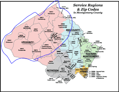
It's confirmed to snow on Sunday 3/3/2019. As of 10:10 AM, there's light snow flying out my window in Gaithersburg. It's coming earlier than expected. Could this mean a boom? Maybe. The question is, will it snow enough to close schools or delay? The snow amounts have to be at least 3 inches to delay because if it's on the weekend, crews have much more time to clear the roads and an inch will be removed quickly. Temps in MoCo when the snow falls are hovering around freezing, so the snowfall rate would have to be heavy to stick to roads and sidewalks. Temps tomorrow is supposed to be below 40 degrees for all of MoCo, so a delay and closure is possible and is a pretty good chance. It's all snow for the upper quarter of MoCo(Damascus, Clarksburg). But the other 3 quarters, mainly the Bethesda quarter of MoCo, will mix with rain and sleet. The other 2 quarters may mix with rain, but it wouldn't mix too much to decrease snow totals by a lot. A Winter Storm Warning is in effect for N&W MoCo with 3-6 inches of snow expected there. For South and Central MoCo, there is a Winter Weather Advisory in effect there. 1-3 inches of snow are expected in the advisory area. Both the Warnings and Advisories start at 12 PM Sunday 3/3/2019 and end at 4 AM Monday 3/4/2019. South and Central MoCo is mainly the most southern quarter of MoCo and the south part of the second quarter, not Gaithersburg. Gaithersburg is expected to get more snow than the most south quarter of MoCo. Let's go see the maps for our area for snow now!
Capital Weather Gang:

NBC 4:
NWS: MoCo is the snow gradient area here, which means the snow(colder air) is fighting the rain(warmer air). The more south you go, there's more mix and rain rather than snow. If you live in Southern and Central MoCo, you are in the snow gradient zone. 1-6 inches in MoCo.

WUSA 9: 3-6+ inches for 52% of MoCo with the other 48% in the 1-3 inches area.
 ABC 7:

Fox 5:

Snowflake Predictions
Zachary's Prediction: 4 snowflakes
Accuracy Rate: 50%(he's only done 2 predictions)
"I have checked all of your sources, and I predict 3 - 5 inches of snow for lower Montgomery County and 4 - 7 for upper Montgomery County. So, I predict 4 snowflakes because remember, when they need to close for one part of the county, they have to close for the whole county."
My Prediction: 3 snowflakes(40% closure 60% chance of delay)
Accuracy Rate:85%

It isn't that much snow, but since highs on Thursday are below 40 degrees, melting will be slow. A delay would help the temps go up more and give more time for crews to clear everything. I don't expect main roads to be snow covered, but secondary and neighborhood roads could be snow covered, especially in upper MoCo. A closure is possible because of the snow amounts in Upper MoCo and the temps and the winter weather lasting till 4 AM, but I don't think so because roads should be okay for the most part. I think MCPS will call a delay and do a re-evaluation at 7 AM. If it booms, my snowflake prediction would be 4 snowflakes.

NBC 4:


WUSA 9: 3-6+ inches for 52% of MoCo with the other 48% in the 1-3 inches area.


Snowflake Predictions
Zachary's Prediction: 4 snowflakes
Accuracy Rate: 50%(he's only done 2 predictions)
"I have checked all of your sources, and I predict 3 - 5 inches of snow for lower Montgomery County and 4 - 7 for upper Montgomery County. So, I predict 4 snowflakes because remember, when they need to close for one part of the county, they have to close for the whole county."
My Prediction: 3 snowflakes(40% closure 60% chance of delay)
Accuracy Rate:85%
It isn't that much snow, but since highs on Thursday are below 40 degrees, melting will be slow. A delay would help the temps go up more and give more time for crews to clear everything. I don't expect main roads to be snow covered, but secondary and neighborhood roads could be snow covered, especially in upper MoCo. A closure is possible because of the snow amounts in Upper MoCo and the temps and the winter weather lasting till 4 AM, but I don't think so because roads should be okay for the most part. I think MCPS will call a delay and do a re-evaluation at 7 AM. If it booms, my snowflake prediction would be 4 snowflakes.
Saturday, March 2, 2019
Sunday Threat
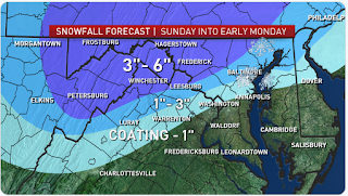
NWS: Coating-8 inches for MoCo


WUSA 9:


"City, St" or ZIP code" or the "Customize Your Weather.gov" box. Then when you have found your location(if you type in the "customize your weather.gov"), press the "Get Detailed info" and read "Sunday" and "Sunday Night".
UPDATE: WINTER STORM WARNING IN EFFECT FOR N&W MoCo. 3-6 INCHES EXPECTED IN WARNING AREA. OTHER AREAS IN A ADVISORY. 1-3 INCHES EXPECTED THERE.
Subscribe to:
Posts (Atom)
-
So, most of the news channels have come with their first call for Wednesday. There is still a winter storm watch, which means that the s...
-
 As many of you know, it's supposed to snow this Sunday. How much is still slightly unclear because of where the snow and rain line is....
