Showing posts with label Mixed Rain/Snow. Show all posts

Monday, February 12, 2024

2/13 Rain to Snow Event for Morning Commute

This will be a quicker post since I only have a little time today. But we went from a generally all-rain storm to potentially quick heavy snow in less than 24 hours. The South trends on modeling with this short of a lead time are quite remarkable, and I'm not sure if I've seen anything like this, at least recently.

 A dynamic system will be approaching from the TN valley, bringing precipitation to the mid-Atlantic and Northeast, a lot of which will be snow. Winter weather advisories are up for those NW of 95 and N of I66. 


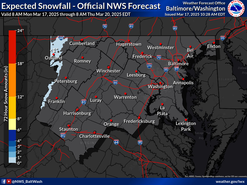
We will start as rain, but likely switch over to snow and see accumulations in these areas. For us, we get cold enough to snow from dynamic cooling; this system will be very dynamic. It depends on rates, and the boom/bust scenarios are equally likely. The bust scenario would be that we do not get heavy rates and little to no accumulation; the boom is that we get heavy rates for a few hours. Despite marginal temps(33-34), heavy snow rates will accumulate, even on sidewalks/roads if heavy enough. This storm will be more of a latitude and elevation-based storm rather than longitude. That's why central/northern MD is more favored in this setup. Even with heavy rates, your ratios will be low and it will be a wet snow.


Precip will likely onset between 5-8 AM, with central MD expected to be all snow by 7-8 AM. Guidance is indicating heavy precip rates, which timed with the morning commute will make it hazardous. It's not more so about the actual amounts, but the heavy rates expected and the timing are perfect to impact the commute. This storm has trended so far south that Maryland gets in on the main snow shield; and not just the backend. Our storm's preformance will depend on these rates. 


There is the potential for 1-3 hours of 1-2"+ rates during the morning commute. With these rates, it will accumulate, even on side roads and paved surfaces. Heavy rates always beat marginal temperatures or any other factor. The previous rain will also make pretreatment impossible. The heaviest rates will likely be just after the switchover(when dynamics are the most favorable), with thundersnow possibilities being hinted by guidance. We won't know what this storm will do until we get there; it is fully dependent on the level and location of banding.

Snow Map + School Predictions:

HREF forecast for the next 24 hours; 2-4" NW of 95 and N of 66 with 4-6" for 70 and north


This is my snow forecast for the event; I think there should generally be at least a solid inch for N of 66; further south should stay under an inch. 3-6" for elevated areas near the MD line and of course, the mountains look like a good call. especially with the recent trends. I would not be surprised at all of the warnings were issued last minute for those regions. The plus in the 1-3 zone is mainly for higher elevated areas. This is a very difficult forecast, with an equal chance for a boom and bust. 1-3" is just in the middle zone and I feel like it will either be a bust/boom. Either way, the morning commute is looking awful, and there will be impacts. As for school impacts...

Prediction: 3 Snowflakes
I'd expect many school impacts, with widespread delays and even closures, especially for counties in the 3-6" zone. The timing of this is perfect to at the very least delay. There is also a 50/50 chance for a closure depending on how long the rates last, and how intense they get. If the rates last for long enough, schools will be forced to close, and there will be enough accumulation on the roads. With the current forecast in place. and the rates guidance is showing,  there is really no way schools can open on time tomorrow.

Overall, a nice sneaky event. I think this is going to surprise a lot of people; enjoy the snow!


Friday, January 5, 2024

1/6/2024 Small Wintry Mix Event


We have a small wintry mix event for NW of 95 that will result in some minor impacts, with impacts increasing the further north and west you go. A low pressure system will track northeastward off the gulf coast and into the Delmarva as it intensifies over SE VA. Precip will overspread the DMV in the morning, starting out as wintry precip for most. Areas along and E of 95 are expected to see very minimal accumulations and a quick transition to a cold rain. 

As the event progresses, strong WAA will warm the 850 mb temps to above freezing as a warm nose is pushed northwestward, while cold air is still at the surface. Unlike a few days ago, this opens the potential to overall wintry precip rather than just snow to rain. These 850mb temps will vary, with the coldest temps being in the mountains and W of the Blue Ridge. Here, the primary ptype will likely be snow. It is very likely that everyone E of the BR will warm enough to see a wintry mix of sleet, freezing rain, and rain(more wintry precip the more NW you go).


The confidence of this storm is generally very low even this close to the event, due to the extremely tight gradient setting up near the RS line; this is going to be a nowcast event. A 1-3 degree difference will make or break this setup. Due to the preceding temps and low wetbulb temps, wintry precip(where it does happen) should stick pretty easily. The best confidence for significant snow is W of I81, the Catoctins and westward, into the mountain counties. Although it seems surface temps were colder than modeled, the 850 mb temps according to IAD sounding look just as modeled, this doesn't really mean anything yet. Nonetheless, most of the region will see some wintry precip, with accumulations starting as soon as you head N and W from the cities.


Making a snow map for this event was difficult, but here are my general thoughts as of now:

Everyone E of 95 sees all rain, this is medium-high confidence. At the very most a couple of flakes may mix in at the border parts, but very little to no wintry precip is expected here. 95 and just NW is looking to see a T-1"(trace does not mean measurable snow). I think everyone here sees at least wintry precip falling, even with a quick transition to rain. This area also has low confidence, and will setup the start of the very large gradient. The more snow accumulation the more NW you go. Immediately NW of DC/Balt(outside the cities), there is some chance for some very minor ice/snow accumulation. This will be washed away quite quickly however.

The light blue zone(for areas closer to DC) I think will see enough snow/sleet to accumulate, as well as some ice accumulation. This area is extremely uncertain though, with the lowest confidence. The dark blue zone is the same idea as the light blue, but more snow/sleet and more ZR. Again, extremely low confidence in these areas; small temp differences can make or break this.

However, the light blue area near I81 is likely going to see large ice accumulations(potential of 0.1-0.25"+ here). This area is W enough to have enough cold air at the surface but WAA will quickly turn most precip here into freezing rain. The predominant ptype here looks like freezing rain, but some sleet/snow will likely fall.

The purple area is much more confident as this area likely stays snow long enough to see moderate accumulations(3-5"). Even here, there is a slight concern that mixing will cut down a bit, but any mixing shouldn't be too long. The predominant precipitation type here is snow. The red area is the bullseye and the mountainous areas. These areas have higher confidence.


Here are the current onset and warning maps, WSWs are up for just E of I81 and westward, as well as Frederick/Carroll Counties. WWAs are all the way down to the metros, primarily due to ice concerns. Generally, if you can avoid travel near I70/I81, do so, but closer to DC, travel shouldn't be too bad. We see an areawide E of I81 transition to mix and then rain by 10AM to 2 PM.


Sunday, December 10, 2023

12/10/2023 Accumulating Snow Event NW of I95

 Guidance has converged on an anafrontal system with a secondary low that provides the opportunity to see some snow, as moisture is thrown from the secondary low into the cold sector. Thus, this gives us to potential to see snow falling, with (light) accumulation prospects NW of 95.


SYNOPSIS:

A shortwave, which has already moved through the country and continues to do so has a cold front ahead of it and northern piece energy. The trough axis is delayed behind the front, so we set up an anafrontal event(not typical).


 This system overall is very dynamic and should have good PVA in front of it which induces cyclogenesis(intensification of the storm) and moisture advection. Temp gradient is also quite large, with the airmass behind the cold front being Canadian and the airmass in front of it being subtropical.


We also have a dual jet setup associated with this which pops a secondary low when the trough becomes negatively tilted, in the Carolinas. This directs winds and moisture return NW.


The large temp gradient should allow for frontogensis forcing, which will make precip rates extremely high. CAA driven snow will occur in the overnight hours after midnight for most people as temps drop.


One thing to note about this system is that surface temps are extremely marginal, but the rest of the atmosphere is <0C, allowing for it to snow. These heavy precip rates will allow for greater dynamic cooling and a saturated column.


OBSERVATIONS:
We are now less than 12 hours away from snow, and the use of models is useless. As of 23z(6P EST), the trough is netural-slightly negatively tilted over MS/AL.


This is ahead of schedule, as it was supposed to be this way at 7-8 PM. This will have better implications downstream as a earlier negative tilt will allow for cold air to fill in faster during the snow, and the secondary low to pop more/quicker in a favorable location.

The cold front was also ahead of schedule, and stronger than modeled, passing the BR by 515-530 PM. 

Temps are dropping quite quickly behind the front, with some station reporting degree drops every 4-5 minutes. Although it is worth noting that sfc temps are warmer than on NAM, they are colder than on HRRR(behind the front), and it just initalized at 22z


The rate temps are dropping behind the CF, catching up to NAMs temps wouldnt take too long either. It's running too warm for some parts of nova at 0z anyways. We'll see though, eitherway temp wise we look good.

And now we look at the radar, we are starting to see the backside precip fill in and amplify. It looks very good with convection off the Carolinas. This system is absolutely juiced, and is exceeding expectatations. 


So overall, it might be safe to say that this event is going slightly better than expectations. Observations look great so far and is expected to continue into the event. 

Overall:

Overall, despite uptrends, the general picture is the same: accumulating snow for NW of 95, mainly in higher elevations. Temps will be very marginal(32-36), but we might push colder during heavy bands due to CAA. That being said, we need heavy snow rates to stick. Otherwise, it will not stick; moderate or below will not do it. Mesoscale banding features are too hard to resolve at this range, so there is no really saying where it will be, but if I had to guess it would be somewhere around here(NW of the fall line): 

As for snowfall, there will be an extremely sharp cutoff on I95. I have trouble thinking anyone inside or east of the beltway will see more than just white rain, with little to no accumulation. Elevation is just too bad there to get anything substantial. Temps will be too marginal there for anything. Even further NW, temps will remain 32-36 for most of the storm, with the exception of lower temps 1000'+ or in the bullseye areas. The reason I'm even going this bullish on accumulations is because of the puking snow rates that will set up somewhere that will stick to the ground despite temps. The rates cannot be moderate or light, they have to be heavy, but we know it will set up somewhere,, and that area should see nice accumulations. Having heavy wind should also help blow the snow around and even help with stickage as wind removes latent heat release; it would help us more than hurt us. This, along w/ heavy rates will make for low visibillity conditions. 

As of N of the fall line, I gave the highest amounts to areas 700'+ elevation and west of I81. The bullseye for this storm overall will be the Blue Ridge and the Apps, as expected. Locally, the bullseye is probably the Parrs Ridge if I'm betting.  In the Parrs ridge, there could be a spot of over 3"+ if everything goes right. I went extra bullish based on new data we have, but this could very well bust. I feel like this is a boom/bust type setup; either we do really well with banding and get puking snow for hours accumulating to over an inch, or we generally stay mostly rain with no acccumulation even if it snows. Ratios will be very low; likely 4:1-7:1 depending on your location.


And as for school impacts, models have trended earlier with the event, generally wrapping snow 5-7A through the region, but before that it will be absolutely puking, along with strong winds as the low intensifies and moves NE. The snow will melt extremely fast afterwards, but I still think theres a chance we could pull off a delay. I'll go 2 snowflakes(50% delay) for this event, if band is a bit later then we'll probably delay. If we can get a WWA in place we probably delay, but it can go either way. Accumulations will mostly be on grassy surfaces, but depending on rates, could be on some side roads and sidewalks. Overall, this event should lock in Dec measurable snow for most areas, and should be really nice to see. 


Saturday, February 12, 2022

Superbowl Sunday Snow


Good afternoon everyone! Today is going to be a very nice day, with highs in the 50s to the2 lower-mid 60s. But as a cold front moves through, and a storm moves behind it, we will be tracking the threat for some snow. The NWS has most of the region(except for the southern part of the region, and western MD) in a winter weather advisory for 1-2" of snow, with local amounts up to 4" of snow. The onset of the storm will start out as rain/mix, but it will turn to snow quickly. Everyone will be snow by the time sunrise happens on Sunday. This will be a light event, and after noon you should be fine to travel. However there might be a refreeze after 4 PM, which could cause some slick spots. Most accumulations will be on grassy surfaces, however there could be accumulation on paved surfaces too. Minor travel issues and slushy spots are not out of the question. High resolution models are starting to pick up on an FGEN band that may occur at the start of the event, that would bring moderate-heavy snow rates. It would dynamically cool the atmosphere and combat warm surface temperatures. I'll look at 2 high-resolution models: NAM NEST & HRRR.


HRRR:

The HRRR shows precip onset as rain, quickly turning over to snow. At 1-3 AM you can see a moderate-heavy snow band in parts of the region. By 3 PM, snow is done for almost all of the region, but I skipped some timeframes at the end to show a backend snow band that the HRRR gives. 


This is the total accumulated snow that the HRRR gives. Remember, not all of it will stick, so actual totals will be a bit lower than this. Gives a widespread 1-3", but I'm skeptical of the widespread 3"+ in parts of north central MD.

This HRRR sounding at 2 AM Sunday shows something interesting. In the sounding, there is intense lift in the DGZ, which allows for moisture and moderate-heavy precipitation rates. This is an FGEN band because you can see the wind barb directions rapidly changing. If you are a snow lover you want to see this happen for more accumulation. This is important because this will dynamically cool the atmosphere to be cold enough to support snow, and would help to quickly overtake the warm surface temps.

NAM NEST:

The NAM shows the inital onset as rain before quickly changing over to heavy snow. It also shows the heavy FGEN band between 1-4 AM, and is actually a bit more robust with the onset of precip compared to the HRRR. It also has the backend snow band, but not as robust as the HRRR.


The snow accumulations are bit more robust compared to the HRRR, but around the same. 


The NAM NEST also shows a nice FGEN band setting up around 1-4 AM, with more lift in the DGZ than the HRRR, creating heavy snow rates. You can see the FGEN banding on the map below setting up, and on the sounding too. I explained what this means while talking about the HRRR sounding. 


Snow Forecast:

More detailed view of the map and interactive map:


The bullseye of this storm will be western central VA, where a FGEN band will drop 3-6" of snow. The FGEN band looks to be better supported there with longer duration leading to more totals. I expect a general 1-3" for most of the region, with C-1" for western MD and C-1" for the southern part of our region. Most accumulations will be in the grass, but there could be some accumulations on paved surfaces too, especially where the FGEN band sets up. Some travel issues and slushy spots on paved surfaces is not out of the question.


Saturday, January 15, 2022

MLK Weekend Storm - What to expect

Good afternoon everyone! We have a winter storm threat to track tomorrow and Monday morning. This threat is looking more like an ice threat instead of a snow threat; but if you live north and west of I-95 you will still see some snow accumulation for this storm. Unless you're far north and west(along and west of I-81), you probably won't see an optimal amount of snow - if you like snow. This storm takes an inland track - so being even a little bit more west can make a difference. When the snow starts, it will be heavy, with rates 1-3" per hour. When it snows, it will thump. Wind gusts up to 45 MPH are possible with this storm, creating the possibility of downed trees and spotty power outages, especially when ice starts to take over the snow. I would recommend to stay off of the roads(if NW of I-95) on Sunday-Monday, as the snow with ice makes roads very slippery and impassible at times. There is a very cold airmass in place for the storm, so ice and snow will stick longer to untreated surfaces. Please note that freezing rain can happen even above freezing, if surface temps and wet bulb are still <32. There is a winter weather advisory for all of MoCo, with 1-3" expected and up to 0.1" of ice. Just north of us is in a winter storm warning, for 2-4" of snow and 0.1-0.3" of ice.


NAM12KM:


Note: at the time where it shows pink for our area(7 PM), I looked at a sounding for Germantown/Gaithersburg and it would seem as if it would be sleet, rather than freezing rain. Still, you can see everyone starts off as snow, and then the warm nose comes in, turning into sleet, then freezing rain, and eventually, when the CAD breaks, cold rain. 


Ice total and snow total maps, pretty self explanatory.


NAM3KM:


The NAM high res shows everyone starting out as snow, then going to ice, and then going to plain rain. The NAM 3KM also shows some backend snow, which is interesting. However, it seems to be light snow, and probably wouldn't amount to much. A lot of the rain will wash all of the snow away, so even if 3" fell, it wouldn't look like it.


The reason why the NAM 3km shows a lot of ice is because of strong southeasterly upper level winds, forcing warm air into the atmosphere and creating a warm nose that gets more dense as time goes on. Eventually, the cold air at the surface breaks, and areas east of I-81 switch to cold rain.


 One other thing I want to talk about is the wind gusts. At this time(8P Sunday), freezing rain is falling all throughout the region. With the strong wind gusts(40-50 MPH wind gusts), isolated power outages and downed trees is likely. I would recommend everyone north and west of I-95 to get ready to deal with some time w/o power, just in case.

*Editors Note: While I was writing this, the 18z NAMs came out, all of the models shown are from the 12z suite

My snow and ice forecast:

(I apologize for very low quality maps, Blogger won't let me put high quality pictures) 


My next update for these maps will be tomorrow morning, after 12z mesoscale runs come in. I'm going bullish with my forecast because I think there will be heavy enough rates for a large enough area to get 2-4" before the changeover to sleet, freezing rain, and then cold rain. I think the NAM is too bullish on the warm air coming in very quickly and changing over to rain, so I didn't use the NAM that much in my forecast. Other models look pretty good for our region in terms of snow, such as the Euro, GFS, and HRRR. My final call WILL be tomorrow morning, after 12z HRRR, and both NAMs come in.

To conclude, I expect 2-4" of snow(possibly more in localized areas) for Northern MoCo and 1-3" for Southern MoCo. For ice, I expect 0.1-0.25" of ice for the general area, with possibly more in localized areas. Timing onset will be in the afternoon, at 1-3 PM. This will be a high impact storm, especially west of I-81, and also for NW of I-95, not just for snow, but for ice. I am very concerned about the ice threat, since CAD is usually undermodeled, especially on global models, and the ice combined with the strong wind gusts could create widespread power outages and downed trees. I'll have a quick update tomorrow, and then I'll do a nowcast.


Sunday, December 26, 2021

Wintry Mix Tomorrow

Good evening everyone! Tomorrow morning, some freezing rain, sleet, and snow is possible for our northern areas. This event will not be significant at all, and I expect minimal accumulations, up to a coating of slushy snow; with all of the (possible) accumlation on grass, with roads staying wet.  Those small amounts may not even occur in the first place. A cold front pushing through this evening creates dew points below freezing, with surface temperatures in the 30s(mainly for northern areas). The event will start out as sleet or snow for northern areas, and then switch over to rain as soon as temps rise. Other than the mountains, icing/snow will not be a threat due to how warm its been recently.


These are the winter weather maps expected by the NWS:

Expected Snowfall - Official NWS Forecast 

Most Likely Ice Accumulation 

Plume for Northern Maryland(Frederick):

As you can see, this plume shows all type of precipitation, with rain being the dominant precipitation. It shows pink(sleet), red(freezing rain), blue(snow), and green(rain). It shows it starting in the early morning, and then as temps rise, the cold rain starts to take over the mix, and eventually wins over the wintry precipitation. The plume mean shows a trace-dusting of snow for Frederick, Maryland. When the rain chances increase in the plume, thats when the precipitation get mixed with rain.


This is the 0z HRRR for tomorrow. It shows an early batch of rain quickly moving through before the snow and mix arrives. When the quick batch of rain arrives, its not cold enough at the surface to support wintry precipitation, so therefore the precipitation falls as rain. However, when the heavier precipitation comes to our area, upper level temperatures are cold enough to support wintry precipitation even with mid 30s at the surface. If the snow falls at a heavy enough rate, there could be a light coating on the grass in some areas. 

To conclude, a wintry mix that transistions to rain is likely if you live north of DC and I-66. It may lead to a possible slushy coating, especially in our more far northern areas. This event will not impact the roads or sidewalks, unless you travel north of the Mason-Dixon line, where WWAs are posted. Precipitation becomes less likely south of DC, and these areas will see just rain, with a very very low chance of mixing.

Featured Post

Archival of Blogger and Move To Substack

Hello everyone, I'm making this post as a formal gesture that I have fully moved to Substack and will not be using this website anymore....