The SPC has issued an extremely rare moderate risk for the DC area, mainly for widespread, significant damaging winds. All other hazards(hail, tornado) are on the table too, and this is a rare overlap of good shear and good instability values in the summer. We have a 10% tornado risk, and a 15% hail risk for most of the region as well.
A trough moving through the plains and Ohio Valley will continue to move and eject over the northern Appalachians this afternoon(0z HREF shown), bringing with it strong mid-level winds which will provide large shear values. WAA will create more than enough moisture for the warm sector.
Due to strong WAA and isentropic lift(last night's rain), there will be low-level cloud cover, but it will be eventually burned out by the August sun. There is already clearing in the Blue Ridge and west, and we should start to burn out cloud cover soon too. And for most places, dews are already in the 70s and are rising.
Storms will grow upscale as they progress eastward. The storm mode will be semi-discrete at first in an environment favorable for supercells, but will turn into a QLCS after(intense and potentially embedded with tornadoes). Low level spin will increase through the evening, so if storms fire later there will be a higher tornado threat due to stronger LLJ, but if its earlier, the tor threat is still present but will be a bit less.
This is a great setup for mid-Atlantic standards and is a serious day. It is rare to get this kind of setup.
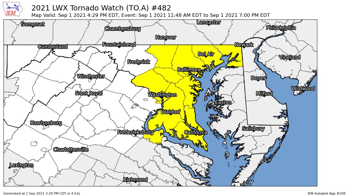
The tornado watch has been trimmed down to only Maryland now.
4:25 PM:
The tornado threat is starting to decrease a little bit, but that doesn't mean that the threat is completely gone. There could still be some tornadoes. Flash flooding is still a concern though. The threat is enough to still pay attention to it.
I'll update this post as new information comes in. I didn't make a post earlier because of some issues with the blog management, sorry about that!
Hello everyone! This is a test post from my new account that will be running this blog. This post won't be detailed or lengthy.
The tornado risk is at its greatest for the next few hours(2:30 PM Onward). 2000-2500 surface CAPE is in most locations in the DMV, and there has already been a wedge tornado in Anne Arundel County, including many others so far. There is a flash flood watch for the entire region, with a flash flood warning in Frederick county.
1-3 inches, with up to 5 inches of rain are possible in some areas.
Hurricane Ida is expected to bring severe storms and tornadoes to the Mid-Atlantic. A good part of Maryland is in an Enhanced Risk(D2, as of 5 PM EDT), for a 10% tornado risk, which is a lot, especially for the Mid-Atlantic. There is also a significant(moderate, red) flooding threat for today and tomorrow. The timing of Ida is between today and Thursday morning.
As you can see, almost all of our region is in the red section, meaning a moderate risk of flash flooding. Areas in the red part can expect "numerous flash floods", with significant flash flooding events likely.
As you can see, for most of Maryland, there is an enhanced risk of severe weather. We usually only get slight/marginal risk, and an enhanced risk doesn't happen that often.
This is the tornado risk for our area(Green = 2%, Brown = 5%, Yellow = 10%). The chances don't seem that high, until you realize that the chances are for every location in those colors to see a tornado.
This is the wind chance. Areas in the yellow have a 15% chance of seeing 58 MPH winds or higher for every location in that yellow spot.
Instabillity tomorrow around the region will be 1500-2000 MLCAPE, which is more than enough to spawn tornadoes. There will also be a lot of shear(up to 70 kts of shear, with 80 kts in isolated areas). The sheer is enough for any thunderstorm updraft to have the potential to spawn a tornado.
TORNADO WARNING FOR AREAS NEAR THE MASON DIXON LINE! SEEK SHELTER IF YOU LIVE ANYWHERE IN THE WARNING!
5:25 PM:
There is a severe thunderstorm warning for areas near the Mason-Dixon line. 60 MPH wind, quarter sized hail, and a tornado is all possible with this storm.
3:35 PM:
The threat for isolated tornadoes and damaging winds should start to increase slightly as the afternoon passes. "Low level shear / SRH remains sufficient to support some tornado threat." - SPC
3:20 PM:
Tornado warning for Allegany and Washington County until 3:45 PM EDT. Seek shelter in a basement or the lowest floor, with the least amount of windows(stay away from windows).
2:50 PM:
A recorded 78F dew point has been recorded in Baltimore and DC! This is a very rare event to get dew points this high(source: capital weather gang), and it means that the air is super moist and humid.
2:10 PM:
There is some signs of rotation in the storm near Ellicott City.
2:00 PM:
There is some rotation in the storm near Waterloo. I'll be keeping an eye on that.
1:50 PM:
It turns out that the best chance for tornadic activity is the I-95 area and east at this point(info from Capital Weather Gang).
1:25 PM:
As storms with heavy rainfall rates(some have rates of 1-2" per hour), conditions become more favorable for isolated, brief tornadoes.
Hello everyone! This is going to be the first weather post I'll be posting for the first time in a month. And to start it off, we are dealing with a tornado outbreak from the ghost of tropical depression Fred! Yes, you heard that right, a tornado outbreak. Veteran storm chaser, Reed Timmer has put our region in the "TORNADO OUTBREAK region".
Reed Timmer has made a premiere about the tornado outbreak for our area.
There is a tornado watch for our region until 8 PM. Small marble sized hail and 70 MPH wind gusts are possible, plus a few tornadoes. This event continues until 8 PM EDT.
There is also a flash flood watch for almost all of the region too, except for our southeastern areas. Rain may fall at a rate of 1-2 inches per hour, and storm totals in isolated areas may even reach up to 3 inches.
MODEL RUN: 15z HRRR
The HRRR shows 1000-2250 MLCAPE for Montgomery County, and up to 2500 MLCAPE for the rest of Maryland. This is more than enough to supply fuel for severe storms.(6PM Eastern).
The 15z HRRR shows around up to 35 kt of shear in Montgomery County, and around 40+ in some parts of Maryland. This is somewhat decent and can help make storms. 4 PM Eastern.
The 15z HRRR shows -5 to -8C of lift, which is a very good amount for storms to spawn.(3P Eastern)
The HRRR shows crazy dew ppoints, with up to 80F dew points in some of Maryland! Thats's crazy, and is very moist and humid for storms to form.
The SPC shows a slight risk for most of Maryland, with a 5% tornado chance for every location to see a tornado in the brown(top right) and in the bottom right, a chance for 58+ MPH winds for any location in the green.
Since this is my first post after a while, I'm not going to go too much into detail. I will update this post as new information comes in.
During the severe weather events of July 1, 2021, there was a tornado warning issued for downtown DC and parts of Arlington County.
As you can see from this picture, any place in the red area was in the tornado warning. Last Friday(July 2nd, 2021), the NWS put out a public statement, confirming 2 tornadoes. Let's take a look at the first one, in Arlington County.
This is the tornado that touched down in Arlington County. It lasted for around 6 minutes, from 8:59 PM EDT - 9:05 PM EDT, and on the Enhanced Fujita Scale, the tornado was an EF-1, with its peak winds at 90 MPH. Thankfully there was no injuries or deaths from this tornado. The maximum width(of the funnel/tornado itself) at its peak was 125 yards, and it covered 4.4 miles. In the picture, the red path is where the tornado crossed, with damage reports shown to determine the strength of the tornado. Remember, the tornado is given a rating on the damage it causes, not its peak wind. From the damage it creates, we can estimate the wind speed of the tornado.
This is the tornado that touched down in DC, specifically in H St Corridor NE-Kingman Park. This tornado earned an EF0 on the Enhanced Fujita Scale, and it lasted for 2 minutes, from 9:08-9:10 PM EDT. At its peak, the winds were 80 MPH. It's maximum width at its peak was 75 yards, and it covered 0.75 miles. The red line shows where the tornado crossed, and the damage reports. The main damage reports here were just trees being down, and large limbs being snapped. Thankfully there were no injuries or deaths.
Tornadoes in DC don't usually happen, and damage from storms are usually from straight-line winds, so this is pretty surprising! Thankfully, no injuries or deaths were recorded from these tornadoes, or the storms that move through as far as I know.
TORNADO WARNING FOR DC. SEEK SHELTER NOW IF YOU ARE IN THE AFFECTED AREA!!
3:35 PM:
There is a flash flood warning for Bethesda and a good amount of Fairfax county. Get to higher ground now if you live in those areas!
3:10 PM:
Severe thunderstorm warning for parts of Northern MoCo, 60 MPH wind and penny sized hail are possible.
2:45 PM:
There is a severe thunderstorm warning for Northern MoCo. 1" hail and 60 MPH wind is possible with this storm.
2:40 PM:
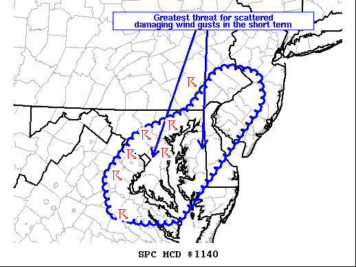
The SPC has issued a mesoscale discussion for most of our area. The area in the circle has the greatest threat for damaging wind gusts(short term).
"Storms have begun to congeal into clusters across
northern VA and MD, with a leading supercell approaching the
Chesapeake Bay. Deep-layer shear of 30-40 kt will continue to
support storm organization, with a mix of multicell clusters and
leading supercells possible. Even though lapse rates aloft remain
modest, hail up to 1.75 inches in diameter has been reported with
the leading supercell in MD. Occasional severe hail may remain
possible in the short term with any storm that can remain at least
semi-discrete. Otherwise, scattered damaging wind gusts will likely
be the primary severe threat as storms continue spreading eastward
this afternoon. The greatest threat for damaging wind gusts should
exist across parts of northern VA into central/eastern MD and DE
where robust heating is supporting MLCAPE of 1000-2000 J/kg and
steep low-level lapse rates. At least an isolated damaging wind
threat may also exist with a small cluster of storms moving eastward
across far southeastern PA into southern NJ, but instability is
comparatively weaker with northward extent across this region owing
to earlier precipitation/storms." - SPC
2:30 PM:
There is a severe thunderstorm warning for southern MoCo. Expect 60 MPH wind and 0.75" hail.
There is a slight risk today for the DMV, and also a flash flood watch for areas east of the Blue Ridge from 2PM this afternoon through tomorrow morning. There is also a severe thunderstorm watch mostly for areas east of the Blue Ridge as well.
There is a severe thunderstorm watch for areas east of the Blue Ridge, including MoCo. Expect 1/2" sized hail(isolated), and wind up to 70 MPH, plus frequent lightning strikes.
There is a slight risk for eastern and semi-northern areas, and a marginal risk for northern areas. The main threats are flooding and wind. In the yellow, is a 15% chance for any area in the yellow to see 58+ MPH winds, and a 5% chance in the green.
This is the flash flood watch. Areas in the green are in the flash flood watch. A widespread 0.5-1" of rain can be expected(areas outside of the watch), but within the flash flood watch, 1-3" of rain can be expected, with localized areas having more.
This is a sounding from the HRRR at 2-3 PM EDT. It shows around 2000 MLCAPE, and a good amount of moisture. The shear is meh, and the lapse rates are generally good.
I'll update this post more often as the day goes on.
*Note: I forgot to make a post earlier, so this is going to be a really quick and concise post, I'll update it as the day goes on and I get new info.
5:25 PM
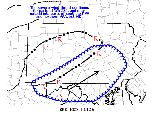
In the past 1 hour, the SPC has issued a mesoscale discussion for most of MoCo, and areas north of it. It says that the severe wind threat continues, where "The severe threat will be greatest on the southern and
eastern edges of the cold pool where temperatures in the mid/upper
90s are maintaining steep low-level lapse rates that will support
damaging winds with any stronger downbursts."
There is also a severe thunderstorm watch for counties north of MoCo, and also northwest of MoCo(does not include northern/western Loudoun county).
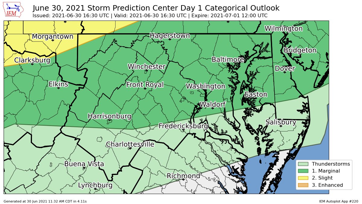
As you can see, there is a marginal risk for almost all of the DMV. Areas in the green(in the photo above) have a 5% chance of seeing 58+ MPH winds 25 miles away from any given point, and areas in the yellow have a 15% chance of seeing 58+ MPH winds 25 miles away from any given point. The main threats here are damaging winds and flooding.
There is a flash flood watch for areas east of the Blue Ridge. Total rainfall amounts of 1-3 inches, with localized amounts up to 4 inches are possible. Rainfall rates from thunderstorms may be 1-2 inches of rain per hour.
There is a severe thunderstorm warning for all of Montgomery County and most of Fairfax and Howard County, plus some of Loudoun County. Expect 60 MPH wind and penny sized hail with this storm(0.75" hail).
2:45 PM Update:
A severe storm watch has been issued for most of the DMV. Expect up to lime sized hail(2" hail!!), wind gusts up to 70 MPH, and frequent lightning. 169 hospitals, 3190 schools, and almost 13 MILLION people are affected by this severe watch.
There is a slight risk for most of the region, marginal risk for our southern regions, and an enhanced risk north of the mason dixon line. The main risks are large hail and damaging winds. This post is gonna be more of a nowcast post instead of a forecast, and I won't go into too much detail today.
In the top left, in the green there is a 2% chance to see a tornado 25 miles away from a certain point, and in the brown a 5% chance to a see a tornado 25 miles away from a certain point. In the bottom left, in the green is a 5% chance to see 1"+ hail 25 miles away from any given point and a 15% chance to see 1"+ hail 25 miles away from any give point in the yellow. In the bottom right, in the green there is a 5% chance to see 65+ mph winds 25 miles away from any given point, a 15% chance to see 65+ mph winds 25 miles away from any certain point, and in the red, a 30% chance to see damaging winds 25 miles away from any given point.
This sounding form the 16z HRRR at 3 PM EDT shows 2000 MLCAPE, a critical angle of 84, good dew points and temperature(Northern MoCo). Shear is pretty bad, but I would assume this sounding supports hail more than wind. There is a good amount of MLCAPE, including critical angle and the dew points are sufficient enough. Only thing that's bad here is the shear.
As I said in the beginning, this is more of a nowcast post then a forecast post, and I tried my best to get this article out as fast as I could. Sorry if it seems a little sloppy. I will update this post as new information comes in.
There is a severe storm for MoCo. Expect quarter sized hail(1"), and 60 MPH winds.
This article is going to be a rather quick post, and I won't be looking into any models or anything, just the SPC risk and the MCD for our area. I will update this post. Sorry for not writing this sooner!
Anyhow, the SPC has issued a slight risk for our area, with the main threat being damaging winds, along with large hail and isolated tornadoes. In the yellow area, there is a 15% chance to see 65+ MPH winds, 1" or larger hail, and a tornado 25 miles away from any given point. The main timing is between 6 PM - 2 AM Tuesday, and storms will continue throughout the night.
A mesoscale discussion has been issued by the SPC for a lot of our area, stating that a severe storm watch is likely, and that strong to severe storms will form as a cold front pushes through the area. Dewpoints of 60-70 plus MLCAPE around 1500-2000 will support severe storms.
.gif)