Sunday, December 26, 2021

Wintry Mix Tomorrow

Good evening everyone! Tomorrow morning, some freezing rain, sleet, and snow is possible for our northern areas. This event will not be significant at all, and I expect minimal accumulations, up to a coating of slushy snow; with all of the (possible) accumlation on grass, with roads staying wet.  Those small amounts may not even occur in the first place. A cold front pushing through this evening creates dew points below freezing, with surface temperatures in the 30s(mainly for northern areas). The event will start out as sleet or snow for northern areas, and then switch over to rain as soon as temps rise. Other than the mountains, icing/snow will not be a threat due to how warm its been recently.


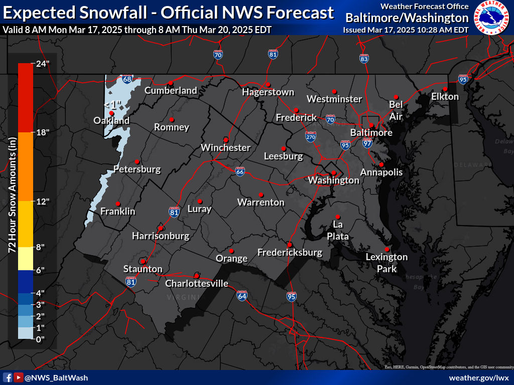
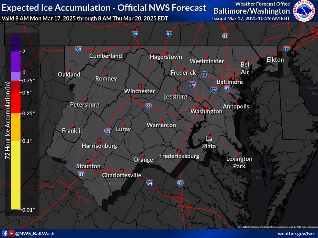
These are the winter weather maps expected by the NWS:

Expected Snowfall - Official NWS Forecast 

Most Likely Ice Accumulation 

Plume for Northern Maryland(Frederick):

As you can see, this plume shows all type of precipitation, with rain being the dominant precipitation. It shows pink(sleet), red(freezing rain), blue(snow), and green(rain). It shows it starting in the early morning, and then as temps rise, the cold rain starts to take over the mix, and eventually wins over the wintry precipitation. The plume mean shows a trace-dusting of snow for Frederick, Maryland. When the rain chances increase in the plume, thats when the precipitation get mixed with rain.


This is the 0z HRRR for tomorrow. It shows an early batch of rain quickly moving through before the snow and mix arrives. When the quick batch of rain arrives, its not cold enough at the surface to support wintry precipitation, so therefore the precipitation falls as rain. However, when the heavier precipitation comes to our area, upper level temperatures are cold enough to support wintry precipitation even with mid 30s at the surface. If the snow falls at a heavy enough rate, there could be a light coating on the grass in some areas. 

To conclude, a wintry mix that transistions to rain is likely if you live north of DC and I-66. It may lead to a possible slushy coating, especially in our more far northern areas. This event will not impact the roads or sidewalks, unless you travel north of the Mason-Dixon line, where WWAs are posted. Precipitation becomes less likely south of DC, and these areas will see just rain, with a very very low chance of mixing.

Monday, December 6, 2021

First Snow Threat of the Season(mini-post)

Good evening everyone! I don't have enough time today to show all of the models and explalin all of my thoughts, so this will kind of be just like a mini-post. I will be getting straightforward to the point starting now. 

The 12z and 18z models are looking pretty decent for us snow-wise. The european model will just not cave to the NAM/GFS/CMC, all which support a snowier solution. The GFS has remained incredibly consistent this whole time, with support from NAM and CMC. NAM high-res shows us dryslotting and not getting that much snow sadly.
Snow Accumulation Prediction
 

As of now I will say a coating to 2 inches of snow for this system on Wednesday. More northern and western areas will see more, you already know the deal with that. Most of the accumulation will be in grassy areas, however it is possible that some roads and sidewalks may be slick/slushy, mainly in our north and western areas(Northern Montgomery County, Loudoun County, Frederick County, etc.). Unless you live quite far south and east, the main precipitation type will be snow throughout the whole event.

And for school predictions... This will be the first time doing this in almost 2 years so I have a decent chance of being inaccurate(plus new superintendent, we will find out how lenient she is with snow day). The main threat isn't really accumulation roads, it is the low visibillity with moderate-heavy snow plus somewhat threatening conditions while the snow is falling. The GFS/NAM shows areas east of I-81 getting hit by a heavy FGEN band(heavy snow band), which could create localized totals of up to 2 inches of snow. It could be heavy enough to stick to some sidewalks and roads.
 

So I will go with: 

2 snowflakes, leaning towards a full day(Somewhere around 45-49% delay)


This could go the other way if the snow comes later in the day and we could see an early-dismissal. This is my first call prediction, and likely will change. Most forecasts have us in the snow region of a trace to 1 inch of snow, and I agree with them. However, the NAM/GFS have been showing this band hitting us for quite a while now, and I can't just rule it out. If this happens, we could very well see some areas getting over 1 inch, and that's why I will be including up to 2 inches in my forecast. There could be a winter weather advisory, but thats only if the NWS gains more confidence in our county getting >1" of snow. If it does get issued, I would say only the northern region will get it from this point out.


Featured Post

2/17 Overnight Moderate Event for DC/Balt Metros

A low-pressure system tracking in southern VA will bring our region snow again. It will move out fast, but will bring good dynamics with it,...