Showing posts with label Ice. Show all posts

Friday, January 5, 2024

1/6/2024 Small Wintry Mix Event


We have a small wintry mix event for NW of 95 that will result in some minor impacts, with impacts increasing the further north and west you go. A low pressure system will track northeastward off the gulf coast and into the Delmarva as it intensifies over SE VA. Precip will overspread the DMV in the morning, starting out as wintry precip for most. Areas along and E of 95 are expected to see very minimal accumulations and a quick transition to a cold rain. 

As the event progresses, strong WAA will warm the 850 mb temps to above freezing as a warm nose is pushed northwestward, while cold air is still at the surface. Unlike a few days ago, this opens the potential to overall wintry precip rather than just snow to rain. These 850mb temps will vary, with the coldest temps being in the mountains and W of the Blue Ridge. Here, the primary ptype will likely be snow. It is very likely that everyone E of the BR will warm enough to see a wintry mix of sleet, freezing rain, and rain(more wintry precip the more NW you go).


The confidence of this storm is generally very low even this close to the event, due to the extremely tight gradient setting up near the RS line; this is going to be a nowcast event. A 1-3 degree difference will make or break this setup. Due to the preceding temps and low wetbulb temps, wintry precip(where it does happen) should stick pretty easily. The best confidence for significant snow is W of I81, the Catoctins and westward, into the mountain counties. Although it seems surface temps were colder than modeled, the 850 mb temps according to IAD sounding look just as modeled, this doesn't really mean anything yet. Nonetheless, most of the region will see some wintry precip, with accumulations starting as soon as you head N and W from the cities.


Making a snow map for this event was difficult, but here are my general thoughts as of now:

Everyone E of 95 sees all rain, this is medium-high confidence. At the very most a couple of flakes may mix in at the border parts, but very little to no wintry precip is expected here. 95 and just NW is looking to see a T-1"(trace does not mean measurable snow). I think everyone here sees at least wintry precip falling, even with a quick transition to rain. This area also has low confidence, and will setup the start of the very large gradient. The more snow accumulation the more NW you go. Immediately NW of DC/Balt(outside the cities), there is some chance for some very minor ice/snow accumulation. This will be washed away quite quickly however.

The light blue zone(for areas closer to DC) I think will see enough snow/sleet to accumulate, as well as some ice accumulation. This area is extremely uncertain though, with the lowest confidence. The dark blue zone is the same idea as the light blue, but more snow/sleet and more ZR. Again, extremely low confidence in these areas; small temp differences can make or break this.

However, the light blue area near I81 is likely going to see large ice accumulations(potential of 0.1-0.25"+ here). This area is W enough to have enough cold air at the surface but WAA will quickly turn most precip here into freezing rain. The predominant ptype here looks like freezing rain, but some sleet/snow will likely fall.

The purple area is much more confident as this area likely stays snow long enough to see moderate accumulations(3-5"). Even here, there is a slight concern that mixing will cut down a bit, but any mixing shouldn't be too long. The predominant precipitation type here is snow. The red area is the bullseye and the mountainous areas. These areas have higher confidence.


Here are the current onset and warning maps, WSWs are up for just E of I81 and westward, as well as Frederick/Carroll Counties. WWAs are all the way down to the metros, primarily due to ice concerns. Generally, if you can avoid travel near I70/I81, do so, but closer to DC, travel shouldn't be too bad. We see an areawide E of I81 transition to mix and then rain by 10AM to 2 PM.


Thursday, February 24, 2022

Snowflake Prediction for Friday

My snowflake prediction for Friday is 2 snowflakes. Exact percentages are 55% delay, and a 10% chance for closure. The reason I'm leaning towards a delay is because the HRRR is now showing a lot more additional ice on top of what we already have throughout the night. Although temps do rise above freezing, there won't be enough time for it to melt for a full day. I think there won't be a closure because temps will rise very quickly above freezing and melt all of the ice. Even though the ice won't accumulate that much on sidewalks and streets, there will be some slick spots in areas with the simulation the HRRR is showing, at the very least. Some streets and sidewalks could be completely covered in ice, especially in areas like Damascus. The storm looks to be overpreforming a bit right now. HRRR isn't picking up on the freezing drizzle that is happening right now too. Temps dont get above freezing until 7 am on the HRRR for some parts of the county. Because of these reasons, I am confident in a delay but not in a closure. Remember: what the HRRR shows is ADDITIONAL ice. The WWA goes until 10 am for Northern MoCo.

Sunday, January 16, 2022

Final Call Snow & Ice Maps and Nowcast


These are my final call snow and ice maps. Almost nothing has changed for the snow map, but the ice map has took a change for the good: The 0.1-0.25"+ zone is now gone, and has been replaced with the 0.01-0.1"+ ice zone. Most people will only see up to a tenth of an inch of ice, but the plus is there for the mountains who will have cold air for longer, allowing for longer ice accumulations. Also some localized areas may see amounts just above a tenth of an inch. Cold air was undermodeled and WAA was overmodeled on high res models if you look at radar. This could mean a longer time period of snow, and just in general wintry precipitation. Surfaces will be below freezing for a while even when temps start to rise above freezing.

Saturday, January 15, 2022

MLK Weekend Storm - What to expect

Good afternoon everyone! We have a winter storm threat to track tomorrow and Monday morning. This threat is looking more like an ice threat instead of a snow threat; but if you live north and west of I-95 you will still see some snow accumulation for this storm. Unless you're far north and west(along and west of I-81), you probably won't see an optimal amount of snow - if you like snow. This storm takes an inland track - so being even a little bit more west can make a difference. When the snow starts, it will be heavy, with rates 1-3" per hour. When it snows, it will thump. Wind gusts up to 45 MPH are possible with this storm, creating the possibility of downed trees and spotty power outages, especially when ice starts to take over the snow. I would recommend to stay off of the roads(if NW of I-95) on Sunday-Monday, as the snow with ice makes roads very slippery and impassible at times. There is a very cold airmass in place for the storm, so ice and snow will stick longer to untreated surfaces. Please note that freezing rain can happen even above freezing, if surface temps and wet bulb are still <32. There is a winter weather advisory for all of MoCo, with 1-3" expected and up to 0.1" of ice. Just north of us is in a winter storm warning, for 2-4" of snow and 0.1-0.3" of ice.


NAM12KM:


Note: at the time where it shows pink for our area(7 PM), I looked at a sounding for Germantown/Gaithersburg and it would seem as if it would be sleet, rather than freezing rain. Still, you can see everyone starts off as snow, and then the warm nose comes in, turning into sleet, then freezing rain, and eventually, when the CAD breaks, cold rain. 


Ice total and snow total maps, pretty self explanatory.


NAM3KM:


The NAM high res shows everyone starting out as snow, then going to ice, and then going to plain rain. The NAM 3KM also shows some backend snow, which is interesting. However, it seems to be light snow, and probably wouldn't amount to much. A lot of the rain will wash all of the snow away, so even if 3" fell, it wouldn't look like it.


The reason why the NAM 3km shows a lot of ice is because of strong southeasterly upper level winds, forcing warm air into the atmosphere and creating a warm nose that gets more dense as time goes on. Eventually, the cold air at the surface breaks, and areas east of I-81 switch to cold rain.


 One other thing I want to talk about is the wind gusts. At this time(8P Sunday), freezing rain is falling all throughout the region. With the strong wind gusts(40-50 MPH wind gusts), isolated power outages and downed trees is likely. I would recommend everyone north and west of I-95 to get ready to deal with some time w/o power, just in case.

*Editors Note: While I was writing this, the 18z NAMs came out, all of the models shown are from the 12z suite

My snow and ice forecast:

(I apologize for very low quality maps, Blogger won't let me put high quality pictures) 


My next update for these maps will be tomorrow morning, after 12z mesoscale runs come in. I'm going bullish with my forecast because I think there will be heavy enough rates for a large enough area to get 2-4" before the changeover to sleet, freezing rain, and then cold rain. I think the NAM is too bullish on the warm air coming in very quickly and changing over to rain, so I didn't use the NAM that much in my forecast. Other models look pretty good for our region in terms of snow, such as the Euro, GFS, and HRRR. My final call WILL be tomorrow morning, after 12z HRRR, and both NAMs come in.

To conclude, I expect 2-4" of snow(possibly more in localized areas) for Northern MoCo and 1-3" for Southern MoCo. For ice, I expect 0.1-0.25" of ice for the general area, with possibly more in localized areas. Timing onset will be in the afternoon, at 1-3 PM. This will be a high impact storm, especially west of I-81, and also for NW of I-95, not just for snow, but for ice. I am very concerned about the ice threat, since CAD is usually undermodeled, especially on global models, and the ice combined with the strong wind gusts could create widespread power outages and downed trees. I'll have a quick update tomorrow, and then I'll do a nowcast.


Sunday, December 26, 2021

Wintry Mix Tomorrow

Good evening everyone! Tomorrow morning, some freezing rain, sleet, and snow is possible for our northern areas. This event will not be significant at all, and I expect minimal accumulations, up to a coating of slushy snow; with all of the (possible) accumlation on grass, with roads staying wet.  Those small amounts may not even occur in the first place. A cold front pushing through this evening creates dew points below freezing, with surface temperatures in the 30s(mainly for northern areas). The event will start out as sleet or snow for northern areas, and then switch over to rain as soon as temps rise. Other than the mountains, icing/snow will not be a threat due to how warm its been recently.


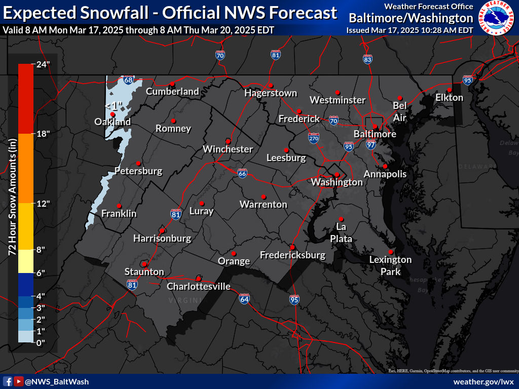
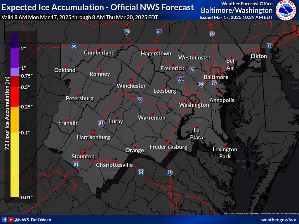
These are the winter weather maps expected by the NWS:

Expected Snowfall - Official NWS Forecast 

Most Likely Ice Accumulation 

Plume for Northern Maryland(Frederick):

As you can see, this plume shows all type of precipitation, with rain being the dominant precipitation. It shows pink(sleet), red(freezing rain), blue(snow), and green(rain). It shows it starting in the early morning, and then as temps rise, the cold rain starts to take over the mix, and eventually wins over the wintry precipitation. The plume mean shows a trace-dusting of snow for Frederick, Maryland. When the rain chances increase in the plume, thats when the precipitation get mixed with rain.


This is the 0z HRRR for tomorrow. It shows an early batch of rain quickly moving through before the snow and mix arrives. When the quick batch of rain arrives, its not cold enough at the surface to support wintry precipitation, so therefore the precipitation falls as rain. However, when the heavier precipitation comes to our area, upper level temperatures are cold enough to support wintry precipitation even with mid 30s at the surface. If the snow falls at a heavy enough rate, there could be a light coating on the grass in some areas. 

To conclude, a wintry mix that transistions to rain is likely if you live north of DC and I-66. It may lead to a possible slushy coating, especially in our more far northern areas. This event will not impact the roads or sidewalks, unless you travel north of the Mason-Dixon line, where WWAs are posted. Precipitation becomes less likely south of DC, and these areas will see just rain, with a very very low chance of mixing.

Friday, February 19, 2021

2/18/2021 Storm Recap

This storm was a bust, in terms of snow totals. However, we got a lot of sleet. I have never seen this much sleet in my life. It was powdery and really good for sledding. A massive refreeze will occur tonight, so leave the salt out.

Snow Totals(sleet included):


This is the amount of snow, sleet included, that fell across the region. It shows 0.8(around an inch) - 3 inches across the county, with the most snow and sleet in NW MoCo. I myself recorded 3 inches of snow and sleet, I know at least 1 inch of snow fell though if we are differentiating both of them. The storm started as snow/sleet but quickly changed to sleet for everyone. Sleet rates were so heavy at times, and surface temps were so cold that the sleet was more powdery than icy. Snow tried to fight back the sleet in Northern MoCo during the onset(5a-12p). Snow started to taper off by then. Light precipitation fell through the afternoon and as we got into the evening, freezing drizzle fell and accumulated on all surfaces. On Friday, on and off light precipitation fell, and another coating, all the way up to 1 inch of snow fell.

Ice Totals:

Most everyone didn't see over 0.1 inches of ice, according to this map(one localized area in NW MoCo has 0.15 inches of ice), although I have localized reports of areas getting up to a quarter-inch, and possibly a little over that. I myself measured 0.20-0.25 inches of ice.

Overall, this storm wasn't a good storm, but it will be somewhat memorable, due to the amount of sleet that fell.


Wednesday, February 17, 2021

Final Forecast for Thursday-Friday Snowstorm and Snowflake Prediction

Well, this may be the first time I am saying this in a long time, but it's looking fairly well for snow lovers. We should see at least 3 inches of snow, and probably more in some areas. However, ice is a huge threat right now, and significant impacts from the ice will occur, such as power outages and severe tree damage. Get prepared now. This is going to be our highest impact storm since 2019, and maybe even 2016. Snow with ice is a terrible combination. The models still haven't come in to consensus though, even less than 24 hours out. It's ridiculous. Winter storm warnings for MoCo and our surrounding counties are in effect right now. It states 4-8 inches of snow and up to 0.1 inches of ice for Upper MoCo, and 3-6 inches for lower MoCo, plus 0.10-0.25 inches of ice. They also said that "snow Thursday morning will be heavy at times with snowfall rates around 1 to 2 inches per hour possible along with visibility reduced to around one-quarter mile at time." The storm will start around 2-4 AM, and end on Friday morning. We will have at least 6 hours of snow, then 6 or so hours of ice, then we will switch back to snow. When talking about models I will also include ice accumulation(if I have that data).

NAM(12km):

The NAM shows heavy snow before turning over into sleet and then eventually tapering off. Models have been trending towards a more lighter event after 2 PM Thursday. It does show less sleet and more heavy snow. In terms of ice accumulation, it practically shows no ice, except for a glaze(<0.01-0.05) in the southern borders.


Snow Accumulation:


The NAM shows 4-7 inches of snow, with more snow in the northern areas than southern areas. The most snow is in the Frederick County/Montgomery County border. The heavy band will drop most of the snow; the NAM shows 2-3 inches before the band and then after the band; totals around 4-6 inches for a lot of the county! This is an improvement and shows that it corrected itself a bit because radar shows the storm strengthening right now and going a tad more south.

European:

The European model shows the heavy snow turning into freezing rain. It does show some scattered snow showers after the main bulk of the storm is done though. Don't have freezing rain totals.


Snow Accumulation:
The European model shows 5-8 inches of snow, with the most snow in NW areas than SE areas. I agree with this model the most in terms of totals. But models are really bad this year, so I really don't know what to choose. Note that this is a 10:1 ratio.

GFSv16:

Snow Totals(someone sent me it who had access to WeatherBell):

This model is a different version of the GFS, yet they are both so different. The GFSv16 is showing over 8-12 inches for MoCo; most areas around 10-11 inches. This is possible if we see heavier snow and less mixing, but there isn't enough confidence to give a clear answer. I think that this would be a boom scenario, but the chances of this happening increase in the northwestern areas of our county, and the chances decrease when you go to the southeastern areas of our county. 10 inches could happen for the whole county, I'm just saying it's more likely in northern areas than southern areas. If the warm air aloft is suppressed enough, this could easily happen. However, we don't know if models are over or underdoing the WAA(warm air advection; pretty much warm air aloft, temps on the surface/ground will be below freezing), since each model has a different opinion and disagreement everywhere. This is a tricky setup, and I don't think I have seen this amount of disagreement this close to the storm. We can hope but don't count on these amounts; just know that it is possible.
GFS:

The GFS shows the storm starting out as heavy snow before turning into a mix, and shows some sort of lull before the precipitation starts again, and it starts to taper off when it's turned back to snow for everyone. I won't be showing the 18z run cause it's completely wrong, and I don't want to mislead my readers. You can check it on Pivotal Weather for yourself if you would like.

Ice Accumulation:
The GFS shows 0.2 inches - 0.5 inches of ice(freezing rain not sleet). This amount would be devastating and would cause major damage, including widespread power outages and extreme tree damage. I don't think we will see this much though, but we will still see enough to cause significant damage.


Snow Accumulation:

The GFS shows 4-7 inches of snow across the county, but its generally scattered. NW areas generally have more snow than SE areas though. I don't agree with these totals, its pretty scattered. The GFS has been not so great with this system, in my personal opinion. It has been proven; showing 3-5 inches in Arkansas, and then those areas under that forecast(of GFS) are getting totals much higher than that.

CMC:
The CMC has shifted south. It shows heavy snow turning over to sleet, then turning back over into snow. I don't have ice totals for this model.

Snow Accumulation:


The CMC shows 4-6 inches for our county, with the highest totals west of us. I don't agree with this model that much but I will show it anyways. This is a 10:1 ratio though.


Maps:

NWS:


The NWS shows 4-6 inches for most of the county, with 6-8 inches for Northern MoCo. If we boom, they expect 6-8 inches for 3/4 of the whole county, with 8-12 inches in the upper quarter of MoCo. If we bust, they expect 1-4 inches of snow, 1-2 inches for Southern MoCo, 2-3 inches for most of Northern MoCo, and 3-4 inches for areas like Damascus and Clarksburg. Boom(high-end) and bust(low-end) maps will be listed below.
High-end totals(boom scenario, more snow than expected)


Low-end totals(bust scenario, less snow than expected)
Ice Totals:


The NWS shows 0.01-0.10 inches of ice for Northern MoCo, where more snow is expected, and 0.10-0.25 inches for Southern MoCo. This is much less than what they have said before thankfully.


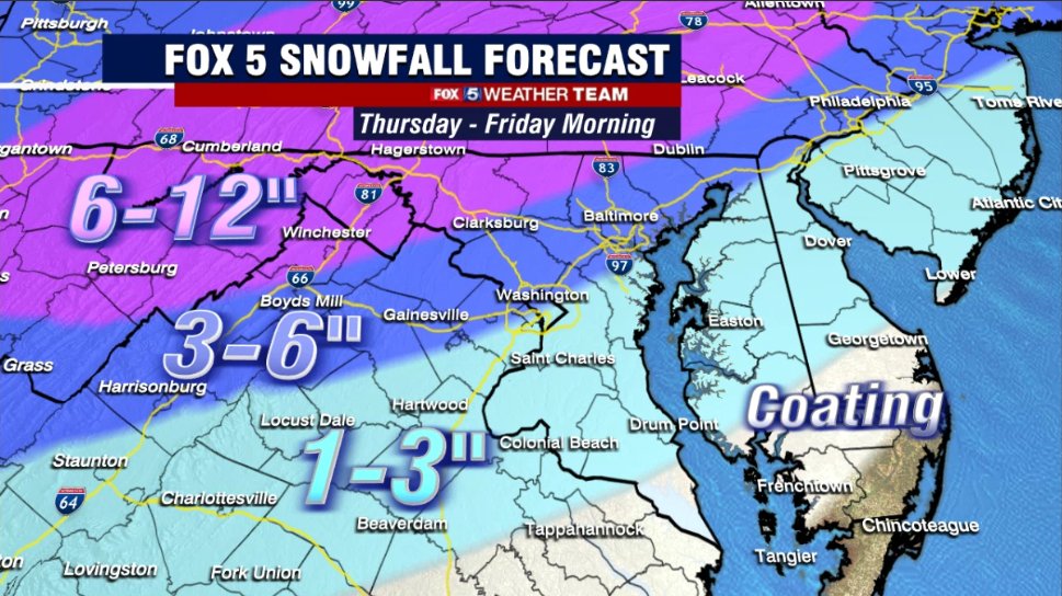
Fox 5:

Fox 5 predicts 3-6 inches for the entire county, with more snow in NW areas than SE areas. They said that areas in the 6-12 inches of snow area are closer to 6 inches than 12 inches.

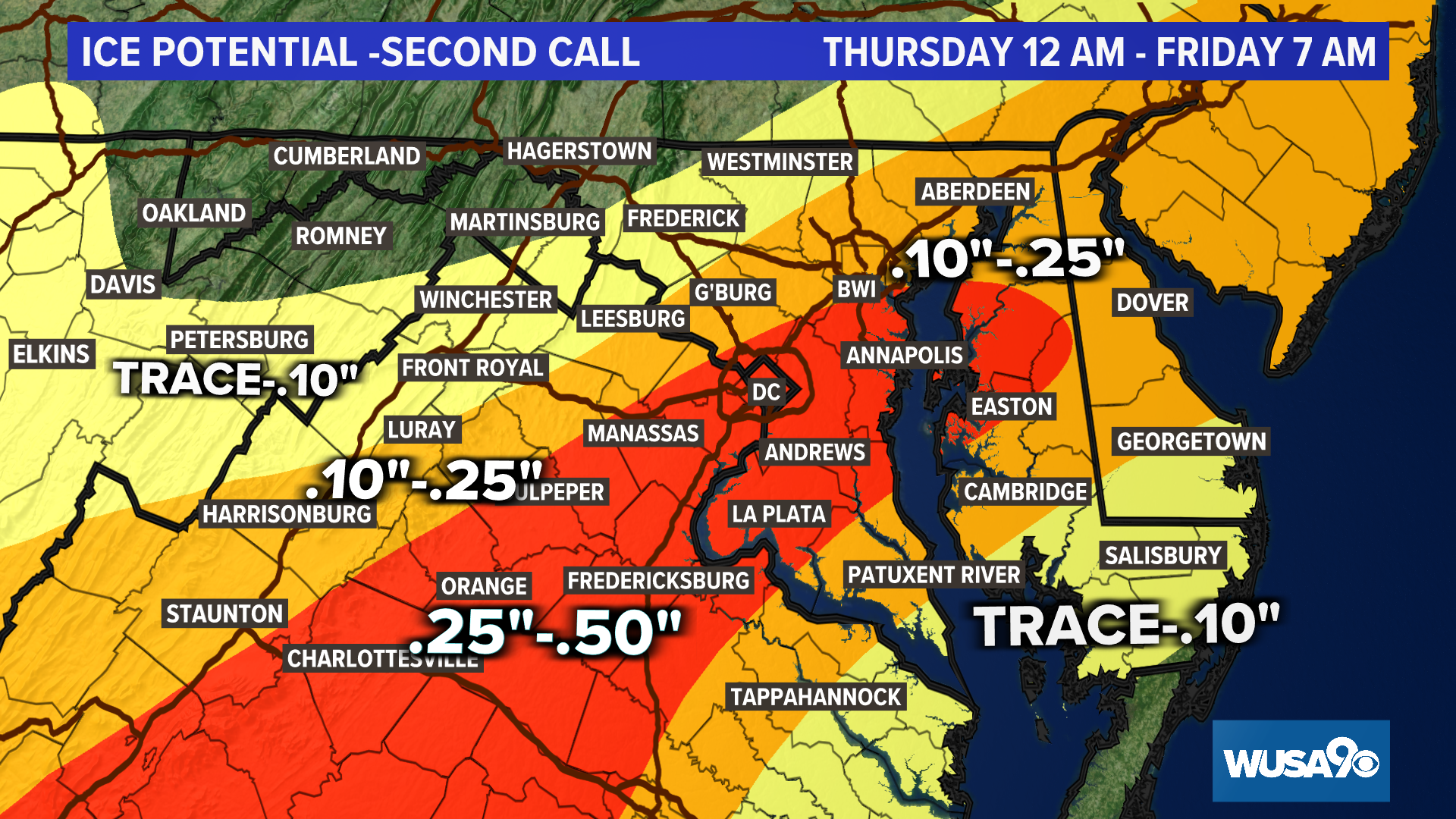
WUSA 9:
Snow Accumulation:

Howard Bernstein shows 6-9+ inches of snow for 55-65% of MoCo, and the southern part of MoCo in the 4-6 inches of snow. He said localized amounts of 10 to 11 inches of snow are possible, but mainly in the mountains(Hagerstown and west).

Ice Accumulation:

They show 0.1-0.25 inches of ice for most of the county, with the MoCo/DC border in the 0.25-0.5 inches of ice section. This would cause major issues.

ABC 7:
ABC 7 thinks 3-6 inches for our entire county. Their map hasn't changed that much.


NBC 4:
NBC 4 shows 2-6 inches for most of our county and 6-10 inches in the northernmost portion of our county. They said that ice will be on top of that 2-6 inches of snow in the dark blue section, and in the purple section, it should be mostly snow.


Capital Weather Gang:

Snow Accumulation:

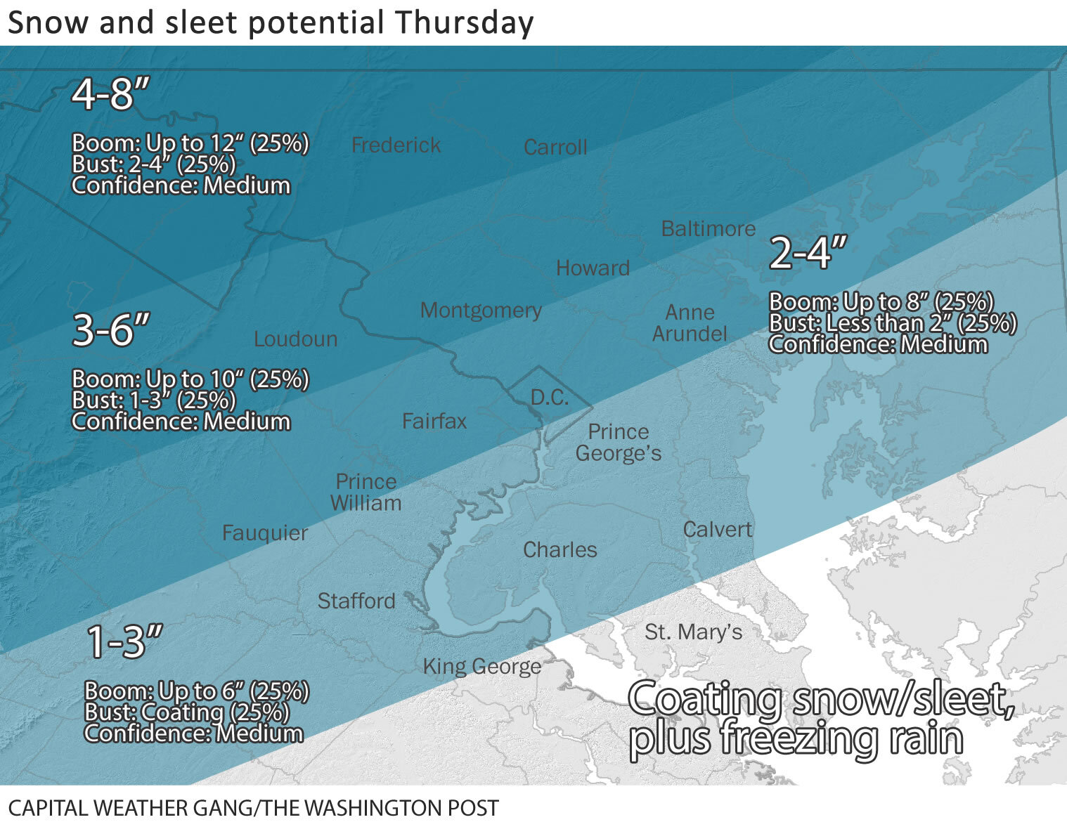
The CWG shows 3-6 inches for most of the county(2/3), and 1/3 of MoCo(southern section) is in the 2-4 inches of snow area. In the 3-6 inches of snow area, a boom would be up to 10 inches, and a bust would be 1-3 inches. In the 2-4 inches of snow area, a boom would be up to 8 inches, and a bust would be less than 2 inches.

Ice Accumulation:

The CWG shows most of our county in the "low threat" region, and our very southern areas in the "Moderate Threat" region, where 0.05-0.2 inches of ice is expected, with a boom being up to 0.4 inches, and a bust being none. If we bust here, we should see more snow. If we boom here, we should see less snow. Temps will remain below freezing the entire time; it is just what is going up in the atmosphere.

QuackyDucc's(my friend's) Snowflake Prediction: 4.5 SNOWFLAKES ❆❆❆❆❄

His statement: "I think that school buildings and virtual learning will be closed tomorrow because of the very high amounts of ice and the future accumulating snow coming."


My Snowflake Prediction(deserves an image): 5 SNOWFLAKES


7:30 AM Update(Thursday): 

Unfortunately for snow lovers, it's looking like an ice storm instead of a snowstorm. Heavy sleet and freezing rain outside my window. Prepare for power outages, cause they are likely. I have downgraded my forecast to 2-4 inches in Southern MoCo and 3-5 inches in Northern MoCo.

9:10 PM Update:

Even though MCPS has called virtual classes to continue, I still think that they will reconsider their decision. Both school and office buildings are closed, which should mean that virtual instruction should close, but it isn't. If they don't reconsider, I honestly think that action can and might be taken against MCPS; this is ridiculous, and I am not just saying this as a student. Many other parents and teachers, even those who are generally against snow days agree this was a very poor decision. Temps areawide is 4-8 degrees colder than expected, making the snow's job to rapidly accumulate even easier. Roads and sidewalks will be a trashy mess. This storm has really grown and gotten gassed up in the past few hours; Arkansas was expected to get 3-5 inches and have now gotten 10-12+ inches of snow. The storm is now even further south than what was modeled, giving us the chance for more snow. I think that the potential for higher snow totals is increasing. So for my snow totals, I will change it to 4-8+ inches of snow for Northern MoCo and 3-6+ inches for Southern MoCo(for snow). The warm nose a little bit warmer than expected though, so I don't know... Snowflake prediction dropped to 3 snowflakes; 50% chance of no school.

I have never been this confident in schools closing for a very long time. I would be completely shocked if virtual instruction wasn't canceled. The University of Maryland has closed in-person and virtual activities, and they are located south of us(granted they are supposed to see more ice). They don't close easily at all, and if they closed for the day, it's a good step in the right direction. Temps will be in the mid to upper 20's the entire time, making sure sticking happens on all surfaces. Heavy snowfall rates, often reaching 1-2+ inch per hour rates will help snow quickly accumulate. The heaviest snow should be between 6 AM - 1 PM. Plows won't be able to keep up with the snowfall rates, and snow-covered surfaces are guaranteed. Surface temps will be below freezing the entire time. I doubt offices will stay open. And the wet, heavy snow plus the ice will cause lots of stress on power lines and will cause spotty power outages, and tree damage. Trees are already somewhat damaged from the ice storm we had on Saturday. Cleanup will become much more difficult when the ice starts coming down and compacting the snow. Over 0.5 inches of QPF are expected to fall with this storm. The storm should start to taper off and become lighter in the afternoon hours, and there might be a lull, but roads will be impossible. Power outages are likely as well, and internet providers may fail with the conditions outside. There is not a doubt school buildings won't close. And virtual learning may cease to work as well. If they don't close, there will be accidents galore. Our storm is more south than what the afternoon models showed, meaning that the storm is picking up more moisture and fuel from the Gulf of Mexico. The high pressure is at the right place so the storm won't go north. Heavier snow bands would enforce dynamic cooling, keeping it mostly snow. I predict 3-6+ inches for Southern MoCo(falling in all, not what is on the ground), and 4-8 inches in Northern MoCo. The snow should start in the early AM hours of Thursday, and start to taper off at 12-2p, where it will slowly start to turn into a mix. Mixing will continue into the night and will switch back to snow. The precip might start to pick up at 5pm, but won't be nearly as heavy as the precip in the morning. The snow in the morning will be really, heavy, and I mean it! Totals should be close to storm totals once the band is done(not the exact same since there is still more snow to go). Prepare for power outages, travel will be impossible tomorrow morning, and will start to become better in the afternoon hours, but will still be dangerous. This will be a high-impact storm and will be since at least 2019. Precip should be all said and done by Friday morning. Expect to wake up to a winter wonderland tomorrow. 


Saturday, February 13, 2021

Ice Storm Warning for MoCo

 There is an ice storm warning in effect for the whole county. This has not happened since February 12, 2008; which is over 13 years! From NWS:

 "...ICE STORM WARNING IN EFFECT UNTIL 7 AM EST SUNDAY...

* WHAT...Two to three-tenths of an inch of sleet and freezing rain causing significant icing impacts. 

* WHERE...The District of Columbia, and portions of central Maryland and northern Virginia.

* WHEN...Until 7 AM EST Sunday.

* IMPACTS...Difficult travel conditions.

* ADDITIONAL DETAILS...Roadways are becoming very icy and dangerous. Avoid all unnecessary travel.

PRECAUTIONARY/PREPAREDNESS ACTIONS...

Travel is strongly discouraged. If you must travel, keep an extra

flashlight, food and water in your vehicle in case of an

emergency. Prepare for possible power outages.

When venturing outside, watch your first few steps taken on

steps, sidewalks, and driveways, which could be icy and slippery,

increasing your risk of a fall and injury."

I can already report a tenth of an inch of ice here in Gaithersburg and a lot of sleet on the ground(over a tenth of an inch of sleet). Pre-treatments are useless, and I can clearly see a coating of sleet on top of the freezing rain. Tree branches are facing down and look like they will snap. It's really coming down here. Every single surface, even treated ones are covered in lots of ice and sleet. Do not travel at all. Power outages are possible, and tree damage will be done. This will be extremely dangerous. There are already so many accidents and injuries on the roads now. Stay safe inside and prepare for an extended period of time without power. Here are some links to help you: What To Do When Lose Power During An Ice Storm, Power Outage Checker(click on your state name), and the National Weather Service for the latest updates on winter weather.

Friday, February 12, 2021

Final Forecast for Saturday-Sunday

 If you are an early riser and live in a generally southern area of MoCo, you might have seen some flurries or maybe even a snow shower outside. Well, that storm is over. Now we move onto the next: Saturday-Sunday. There is a winter weather advisory for the entire county, stating up to 1/10 inches of ice, and for freezing rain with sleet mixed at times to fall.  Thankfully, the models have been trending for less precipitation, and therefore less ice, but this is still to be taken seriously. This is at least a moderate ice event. I would highly recommend trying to move any plans on Saturday and Sunday to a later date. 1 PM to 11 PM Saturday will be the key timing for this storm when the ice will accumulate the most.

GFS:

The GFS shows a scattered wintry mix of sleet and freezing rain rather than an organized storm(and that second part coming from the west doesn't hit us).
The GFS shows 0.025 - 0.1 inches of ice. It has been trending for less ice(freezing rain) and more sleet.


NAM(12KM):

The NAM shows an icy mix instead of just freezing rain. It shows it is over fast.

The NAM shows 0.01-0.05 inches of ice.

European:


The European has been the most aggressive model for this storm since the day it showed up, and to now. It shows 12 hours of moderate-heavy freezing rain for the whole county before moving out.

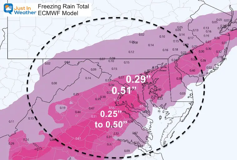
Image Courtesy of Justin Weather

The European model shows 0.25 - 0.5 inches of ice for most of our county and 0.2-0.25 inches of ice for the upper quarter of MoCo. This would be enough to do some damages to branches and cause possible spotty power outages.


Capital Weather Gang:

The Capital Weather Gang has most of our county in the "Moderate Threat" area with the northern cap of our county in the "Slight Threat" area. They expect hazardous untreated surfaces for all of our county, and 0.05-0.2 inches of ice, with some sleet mixing in.

NWS:


The NWS shows 0.01-0.10 inches of ice for our whole county, and <1" of snow.

Surfaces will be cold enough to support ice or any type of wintry precipitation if they are untreated. The most ice is expected south of us. We may start out as snow, but will quickly turn over into freezing rain/an icy mix. What appears to be wet is most likely ice. Just a little bit of ice can cause big problems. Although this won't be a power outage type of ice storm, it still will be enough to make surfaces dangerously slick. This storm will go from 7 AM Saturday to 10 AM Sunday. Stay safe!


Featured Post

Archival of Blogger and Move To Substack

Hello everyone, I'm making this post as a formal gesture that I have fully moved to Substack and will not be using this website anymore....