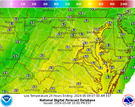
Our first heat wave of the season is expected, with 3 days of above 90 degree temperatures expected, from Friday to Sunday! The hottest day will be Saturday, with highs in the mid to upper 90s. Heat indices will be in the mid-upper 90s and will be around 100 for some areas.
High temperatures for Friday
High temperatures for Saturday
High temperatures for Sunday
The first heat wave is the most dangerous as people aren't used to the heat yet! Make sure to take breaks and stay hydrated outside.
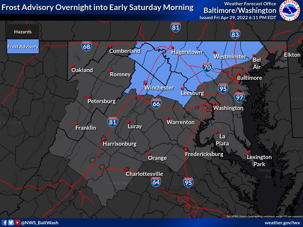
There is a frost advisory for areas NW of I-95 for areas highlighted in the blue in the image above, for temperatures as low as 33, which will produce frost formation. This is in effect from 2 AM Saturday to 9 AM Saturday, where temps are expected to be at their coldest. The frost could kill sensitive plants if they are not taken inside/left uncovered. If you have plants, take steps to protect them from the cold.
Good evening everyone! Over the past week or so I have been tracking a winter storm threat for the DC area on Saturday. In the past 24 hours, models have consistently trended colder and more southeast, allowing for our region to garner higher snow accumulations. There is a winter weather advisory for I-95 corridor and north and west of that. 2-4" is expected in I-95 corridor, while 3-5" is expected NW of 95. The cold air will come in quickly and strong tomorrow. There will be a brief period of sleet while we transition over to snow tomorrow, which will help snow accumulate better. The freeze will also aid with this. The winds will be very strong tomorrow. Many areas will see wind gusts in excess of 50 MPH, up to 55 MPH. Due to winds and the heavy snow expected, blizzard conditions are possible tomorrow, particularly between 8 - 11 AM. In the WWA, it states the possibility for this. Thundersnow is also possible, mainly when we transition into snow(soundings support it). Winds are quite undermodeled. Tomorrow morning, we will have an FGEN band that will setup west of DC, but east of I81 as the transition to snow occurs. Rates could be 1-3" per hour in this band. Because of this, I really think west of DC should be placed under a winter storm warning. Just because it was 60 today does not mean snow will not accumulate. There have been many times where there were mild temps before onset of snow, and areas got a good amount of snow(1/3 as an example). I'll show some of the 18z mesoscale models here.
HRRR:
The HRRR has a very impressive snow accumulation, with the bulk of the snow falling in 6 hours. Latest runs of the HRRR are uptrending on snow accumulation too. I think this could be a legit overpreformer for our region, dynamics and FGEN banding are very impressive. The soundings from the HRRR scream FGEN band(winds rapidly veering with height, ample amount of omega and lift in DGZ) with good snow growth. I would cut totals by about 1/3 for a more realistic amount, but still a very impressive amount.
NAM 12KM:
NAM is quite impressive with snow accumulations, with a widespread swath of 6" and higher. Again I would cut totals by 1/3 - 1/2, but this was a big improvement from last run. The reason why is that NAM is slower, and colder and east, allowing for more snow accumulation. NAM 3KM supports this too.
NAM NEST(3KM):
The NAM 3KM is very impressive with dynamics + FGEN and supports the low-resolution NAM's solution. NAM 3KM is also impressive with a wide swath of 6"+. Again cut totals by 1/3-1/2. Much better than last run.
NAM 3KM has an impressive FGEN band moving through the region as rain turns into snow. A sounding reveals ptype being snow, with good dendritic growth. Winds rapidly veer, which indicates FGEN. There is good lift in the DGZ with nice omega values. This is a good sounding for heavy snow, and for strong dynamic cooling. This sounding also indicates some possible thundersnow in some areas.
My snow map:
Here is my final snowfall map. In the red, you can expect 4-8" of snow(Blue Ridge, Catoctin Mountains, Western MD). North of DC, you can expect 3-6" of snow. Most of the region DC and south are in the 1-3" range. Far southeastern parts of our region can expect C-1". I went a little bit bullish on the snow map because of latest trends on guidance leading to more snow. The dynamics and setup from this event is quite impressive. Even though rates are still uncertain, a FGEN band that will allow for these totals to come to fruition. The north winds will help blow snow and help transport cold air here. When rain transitions over to snow at around 5-8 am for most of the region, there will be a brief period of sleet. This will help snow accumulate, including the flash freeze. This will be a nice event for March. Whiteout conditions at times cannot be ruled out, and near blizzard conditions for somewhere are likely at one point at time. Even thundersnow is possible tomorrow(transition to rain - snow). This will probably be the last snow event looking at long range models, so enjoy everyone! Main roads should be fine but secondary roads will likely cave to the high snowfall rates.
My snowflake prediction for Friday is 2 snowflakes. Exact percentages are 55% delay, and a 10% chance for closure. The reason I'm leaning towards a delay is because the HRRR is now showing a lot more additional ice on top of what we already have throughout the night. Although temps do rise above freezing, there won't be enough time for it to melt for a full day. I think there won't be a closure because temps will rise very quickly above freezing and melt all of the ice. Even though the ice won't accumulate that much on sidewalks and streets, there will be some slick spots in areas with the simulation the HRRR is showing, at the very least. Some streets and sidewalks could be completely covered in ice, especially in areas like Damascus. The storm looks to be overpreforming a bit right now. HRRR isn't picking up on the freezing drizzle that is happening right now too. Temps dont get above freezing until 7 am on the HRRR for some parts of the county. Because of these reasons, I am confident in a delay but not in a closure. Remember: what the HRRR shows is ADDITIONAL ice. The WWA goes until 10 am for Northern MoCo.
Good evening everyone! We have a threat for a wintry mix from Thursday to Friday, mainly north of DC metro. Models have been trending south and colder for the past day or two. The highest ice will be near the mason dixon line. Unlike the other ice event that busted, this is a cold air damming event, which tends to be undermodeled. This will not be a snow threat, and the main focus of this will be ice and sleet. Although precipitation onset could be snow, almost all of it will turn into sleet/ice quickly. Precipitation onset has been delayed a few hours to after sunset, which would lead to a better environment for ice to accumulate. Main roads most likely won't be a problem, however secondary roads and sidewalks could have some slick spots, especially north of I-70 and in higher elevation areas such as Damascus. A potential delay is possible on Friday, but I won't make a prediction until we get into the event and surface obs.
Now, I will show what some model simulations are for this storm.
RGEM/RDPS:
This is the RGEM model. It has done quite well this winter. The location of the ice accumulation is realistic, and fits with climatology. However, ice totals are still definitely overdone. The RGEM would give us a scenario for a delay, as ZR lasts in Damascus for until 11a-12p. This solution matches up more with surface temperatures. It has shifted south and colder compared to its last run.
Euro:
Euro is a bit more conservative with the ice totals, but still overdone in some places. It has shifted south and colder compared to its previous run. For Friday 1a, it gives Germantown rain on ptype map, when it should be ZR as temperatures are 32, supporting freezing rain. The Euro and RGEM line more up with my thinking and climatology on where ice accumulations will be.
About the NAM. It has a cold bias and spits out a very cold solution, with ice accumulation for even southern parts of our region. Although it does do well with CAD, it is quite unreasonable. Ground temps will not cool instantly, and NAM assumes it does. As I said earlier, it has a cold bias, so it is also unreasonable in the ptype solution it puts out. Even with later onset time, I just don't see it happening.
Here is my first call ice map:
I will have an update with a school prediction for Friday and with mesoscale models + surface obs tomorrow.
Good afternoon everyone! Today is going to be a very nice day, with highs in the 50s to the2 lower-mid 60s. But as a cold front moves through, and a storm moves behind it, we will be tracking the threat for some snow. The NWS has most of the region(except for the southern part of the region, and western MD) in a winter weather advisory for 1-2" of snow, with local amounts up to 4" of snow. The onset of the storm will start out as rain/mix, but it will turn to snow quickly. Everyone will be snow by the time sunrise happens on Sunday. This will be a light event, and after noon you should be fine to travel. However there might be a refreeze after 4 PM, which could cause some slick spots. Most accumulations will be on grassy surfaces, however there could be accumulation on paved surfaces too. Minor travel issues and slushy spots are not out of the question. High resolution models are starting to pick up on an FGEN band that may occur at the start of the event, that would bring moderate-heavy snow rates. It would dynamically cool the atmosphere and combat warm surface temperatures. I'll look at 2 high-resolution models: NAM NEST & HRRR.
HRRR:
The HRRR shows precip onset as rain, quickly turning over to snow. At 1-3 AM you can see a moderate-heavy snow band in parts of the region. By 3 PM, snow is done for almost all of the region, but I skipped some timeframes at the end to show a backend snow band that the HRRR gives.
This is the total accumulated snow that the HRRR gives. Remember, not all of it will stick, so actual totals will be a bit lower than this. Gives a widespread 1-3", but I'm skeptical of the widespread 3"+ in parts of north central MD.
This HRRR sounding at 2 AM Sunday shows something interesting. In the sounding, there is intense lift in the DGZ, which allows for moisture and moderate-heavy precipitation rates. This is an FGEN band because you can see the wind barb directions rapidly changing. If you are a snow lover you want to see this happen for more accumulation. This is important because this will dynamically cool the atmosphere to be cold enough to support snow, and would help to quickly overtake the warm surface temps.
NAM NEST:
The NAM shows the inital onset as rain before quickly changing over to heavy snow. It also shows the heavy FGEN band between 1-4 AM, and is actually a bit more robust with the onset of precip compared to the HRRR. It also has the backend snow band, but not as robust as the HRRR.
The snow accumulations are bit more robust compared to the HRRR, but around the same.
The NAM NEST also shows a nice FGEN band setting up around 1-4 AM, with more lift in the DGZ than the HRRR, creating heavy snow rates. You can see the FGEN banding on the map below setting up, and on the sounding too. I explained what this means while talking about the HRRR sounding.
The bullseye of this storm will be western central VA, where a FGEN band will drop 3-6" of snow. The FGEN band looks to be better supported there with longer duration leading to more totals. I expect a general 1-3" for most of the region, with C-1" for western MD and C-1" for the southern part of our region. Most accumulations will be in the grass, but there could be some accumulations on paved surfaces too, especially where the FGEN band sets up. Some travel issues and slushy spots on paved surfaces is not out of the question.
Unfortunately, the thing that I feared the most to snow days happened: MCPS is now going to go virtual for most snow days. However, there is a catch, thankfully. They will consider going virtual for inclement weather. This means that there will be some inclement weather days that will have a traditional snow day rather than a virtual learning. On a virtual learning inclement weather day, the schedule will operate on a 2 hour delay -- except it's on Zoom. Delays and early-releases will still operate as normal.
I will still be posting about weather that impacts the DC area, and still make school predictions about what MCPS will do, no matter what happens to snow days.
I have updated the snowflake rating system and added a new rating system:
The CHROMEBOOK rating system
The chromebook rating system is used to predict whether or not there will be a traditional snow day or a virtual learning day if MCPS needs to close in-person school for inclement weather. It is still undetermined what MCPS goes virtual for -- and what MCPS goes traditional snow day for. I assume that if there is a lot of snow -- especially wet, they will call a traditional snow day. It is still undetermined and no one knows what they will do what for since we havent gotten a snow day with this new rule in effect.
Here is the new Chromebook rating system:
Most Likely Virtual Learning(if closure in-person):
1 Chromebook: Most Likely Virtual Learning
2 Chromebooks: 35% Chance of Traditional Snow Day
Most Likely Traditional Snow Day(if closure in-person):
3 Chromebooks: 55% Chance of Traditional Snow Day
4 Chromebooks: 75% Chance of Traditional Snow Day
5 Chromebooks: Most Likely Traditional Snow Day
And for weather news, there is a storm signal around February 14th(Valentine's Day) that I will be watching. It is still too far out to discuss anything about the storm -- at this point in time we just want to see if the pattern supports it. That is all for this post.