Sunday, December 10, 2023

12/10/2023 Accumulating Snow Event NW of I95

 Guidance has converged on an anafrontal system with a secondary low that provides the opportunity to see some snow, as moisture is thrown from the secondary low into the cold sector. Thus, this gives us to potential to see snow falling, with (light) accumulation prospects NW of 95.


SYNOPSIS:

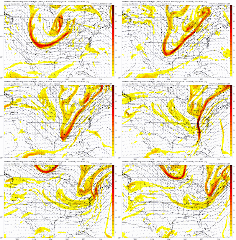
A shortwave, which has already moved through the country and continues to do so has a cold front ahead of it and northern piece energy. The trough axis is delayed behind the front, so we set up an anafrontal event(not typical).


 This system overall is very dynamic and should have good PVA in front of it which induces cyclogenesis(intensification of the storm) and moisture advection. Temp gradient is also quite large, with the airmass behind the cold front being Canadian and the airmass in front of it being subtropical.


We also have a dual jet setup associated with this which pops a secondary low when the trough becomes negatively tilted, in the Carolinas. This directs winds and moisture return NW.


The large temp gradient should allow for frontogensis forcing, which will make precip rates extremely high. CAA driven snow will occur in the overnight hours after midnight for most people as temps drop.


One thing to note about this system is that surface temps are extremely marginal, but the rest of the atmosphere is <0C, allowing for it to snow. These heavy precip rates will allow for greater dynamic cooling and a saturated column.


OBSERVATIONS:
We are now less than 12 hours away from snow, and the use of models is useless. As of 23z(6P EST), the trough is netural-slightly negatively tilted over MS/AL.


This is ahead of schedule, as it was supposed to be this way at 7-8 PM. This will have better implications downstream as a earlier negative tilt will allow for cold air to fill in faster during the snow, and the secondary low to pop more/quicker in a favorable location.

The cold front was also ahead of schedule, and stronger than modeled, passing the BR by 515-530 PM. 

Temps are dropping quite quickly behind the front, with some station reporting degree drops every 4-5 minutes. Although it is worth noting that sfc temps are warmer than on NAM, they are colder than on HRRR(behind the front), and it just initalized at 22z


The rate temps are dropping behind the CF, catching up to NAMs temps wouldnt take too long either. It's running too warm for some parts of nova at 0z anyways. We'll see though, eitherway temp wise we look good.

And now we look at the radar, we are starting to see the backside precip fill in and amplify. It looks very good with convection off the Carolinas. This system is absolutely juiced, and is exceeding expectatations. 


So overall, it might be safe to say that this event is going slightly better than expectations. Observations look great so far and is expected to continue into the event. 

Overall:

Overall, despite uptrends, the general picture is the same: accumulating snow for NW of 95, mainly in higher elevations. Temps will be very marginal(32-36), but we might push colder during heavy bands due to CAA. That being said, we need heavy snow rates to stick. Otherwise, it will not stick; moderate or below will not do it. Mesoscale banding features are too hard to resolve at this range, so there is no really saying where it will be, but if I had to guess it would be somewhere around here(NW of the fall line): 

As for snowfall, there will be an extremely sharp cutoff on I95. I have trouble thinking anyone inside or east of the beltway will see more than just white rain, with little to no accumulation. Elevation is just too bad there to get anything substantial. Temps will be too marginal there for anything. Even further NW, temps will remain 32-36 for most of the storm, with the exception of lower temps 1000'+ or in the bullseye areas. The reason I'm even going this bullish on accumulations is because of the puking snow rates that will set up somewhere that will stick to the ground despite temps. The rates cannot be moderate or light, they have to be heavy, but we know it will set up somewhere,, and that area should see nice accumulations. Having heavy wind should also help blow the snow around and even help with stickage as wind removes latent heat release; it would help us more than hurt us. This, along w/ heavy rates will make for low visibillity conditions. 

As of N of the fall line, I gave the highest amounts to areas 700'+ elevation and west of I81. The bullseye for this storm overall will be the Blue Ridge and the Apps, as expected. Locally, the bullseye is probably the Parrs Ridge if I'm betting.  In the Parrs ridge, there could be a spot of over 3"+ if everything goes right. I went extra bullish based on new data we have, but this could very well bust. I feel like this is a boom/bust type setup; either we do really well with banding and get puking snow for hours accumulating to over an inch, or we generally stay mostly rain with no acccumulation even if it snows. Ratios will be very low; likely 4:1-7:1 depending on your location.


And as for school impacts, models have trended earlier with the event, generally wrapping snow 5-7A through the region, but before that it will be absolutely puking, along with strong winds as the low intensifies and moves NE. The snow will melt extremely fast afterwards, but I still think theres a chance we could pull off a delay. I'll go 2 snowflakes(50% delay) for this event, if band is a bit later then we'll probably delay. If we can get a WWA in place we probably delay, but it can go either way. Accumulations will mostly be on grassy surfaces, but depending on rates, could be on some side roads and sidewalks. Overall, this event should lock in Dec measurable snow for most areas, and should be really nice to see. 


Friday, November 24, 2023

Winter Outlook 2023-24

full 36 page read/analysis: https://tinyurl.com/223zv9ec

Analogs:


Top ENSO analogs: 1957/1965/1991*

MEI Analogs1986/2009

Top Pacific Analogs: 1965/1972/1995

Polar Analogs: 1957/1965/1987/2009

EMI/Orientation Analogs: 1982/1991*/2015

1957/1965/1972/1987/2009 are my highest weighted analogs

DJF Weighted Temp/Precip Composite


The ENSO will likely end up as a basin-wide(with more of a western lean like 1957/65 as Nino 4 warms and Nino 1+2 cools), with periods of Modoki forcing. I do not think that this is a wall to wall cold and snowy winter, but rather bouts of favorable patterns/timeframes, with most of the bulk being in the second half of the winter(Feb). I think we overall end up N-slightly AN for the winter, with Feb being BN, and Dec slightly AN, with Jan being around N. There’s too much variability and unpredictability to pinpoint specific temp anomalies for those specific months, but I still think we overall end up N-slightly AN.

Snowfall:
 

The range this winter is extremely large, with the maximum high-end potential being a top 5 winter or another horrible, low-snow winter. Strong+ ninos tend to be very boom or bust winters. With the exception of 1994/95, every analog year I had was either under 10” or over 30”. As I mentioned before, the main thing that will determine the fate of this winter is the polar domain. With the -QBO/++AMO, as well as bouts of favorable forcing setting up at times, the polar domain is looking good for this winter. While we have a -PDO, the strong El Nino will win out and override the state. The warmest anomalies being over and east of the dateline is a very good thing and very different to the forcing we’ve been seeing over the past few years. The active STJ should provide us with plenty of storm opportunities and ample moisture, snow or rain regardless. Thus, this is also the best chance since 2016 for a HECS/KU. Even if we don’t get a KU, the active STJ provides many opportunities for multiple SECS/MECS. 


That is why I went well AN for snowfall for this year. I doubt we see a near-normal year; either much BN or much AN. There is a lot of potential this year, and as of now, things seem to be looking good. The warm Atlantic will also provide extra moisture for storms. Going around the mid-range this year for snowfall doesn’t appear to be a good idea. This year definitely won’t be that cold overall, but we don’t need extreme back-to-back cold anomalies to get snowfall. All we need is one wave to time up right. With a Nino, the Pacific shouldn’t be too much of a problem this year. ENSO influences PDO, not the other way around; especially at this strength. 


I also went for a more N/S gradient in my map than a W/E gradient. The big nino years here had a more north-south orientation for the gradient than a west-east(obviously being more west still favors more). Although we’ll see some CAD storms, especially earlier in the season, I don’t think we’re going to be seeing too many of them overall. I think the PNA this year will average out to be neutral-slightly positive, with the western ridge flexing at times, increasing in frequency as the winter progresses. This should favor more Miller A/C type storms, which generally aren’t as W/E gradient oriented. 

Given how things appear to be progressing, and the best-looking year in several years, I believe that going bullish on a high snowfall winter is the right decision to make.

Summary:


Overall, I am sold for a well AN snowfall winter for the Mid-Atlantic and SE, and BN for NE. The strong Nino and STJ should heavily favor the MA/SE, and lead to suppression issues not much further north. ++AMO favors further S blocking, which in turn favors a further southern displaced track. Along with the STJ and other factors, the main focus of this winter on the EC will likely be the MA.


December, although not favored by Nino climatology, doesn’t look that bad anymore, and might be AN in snowfall, with a -NAO setting up for the early part of the month, and forcing returning to favorable phases by mid-late month. Although I expect it to still end up slightly AN, there’s definitely the possibility of the month ending up near normal. We should have a generally transient warmup in mid-Dec before returning to a favorable period later in the month. Although climo before mid-Dec is at best dubious, it is certainly possible to get some events, especially with the pattern setting up. For the month, I could see us getting a few minor events, and maybe even a moderate event. The very end of the month seems to be the best time period for something. I do not expect the PNA to be overall positive, but we could get a few transient +PNA flexes, along with HL blocking around this time. HL blocking setting up in December; and an -NAO is a very good sign for the winter and for higher-magnitude blocks to set up later in the winter. 


January looks to be alright, with the favorable forcing from late Dec continuing into the early part of the month. As stated previously, this month will generally be transitional, but the pattern at the start of the month will remain favorable. Thus, after early Jan, it appears to be quiet for a bit, until the end of Jan, where the pattern will become favorable again and continue into Feb. This is also when peak climo starts. Again we might see some +PNA flexes, but it should remain generally variable throughout the month. We should end up around N for this month temp-wise, and snowfall.


February will easily be the best part of this winter, with everything lining up: frequent +PNA flexes, favorable forcing setting up, HL blocking, active STJ, and overall peak climo should make Feb exciting. This isn’t too much of a surprise though, as Nino climatology heavily is backloaded and protrudes Feb as the coldest, snowiest month. We should definitely end up BN for this month in temps and AN in snowfall.


As for indices:


  • PDO: slightly BN; -0.4 to -0.9

  • AO: slightly BN; -0.2 to -0.5

  • PNA: N-slightly AN; -0.1 to +0.3

  • NAO: N; -0.2 to +0.2

  • ENSO peak: 1.7-2.0(under super)

  • ENSO Orientation: West-Tilted Basin-Wide


overall, should be a fun winter to track w/ the first real nino since 2015


Monday, August 7, 2023

RARE MODERATE RISK BY SPC FOR DC AREA 8/7/23

The SPC has issued an extremely rare moderate risk for the DC area, mainly for widespread, significant damaging winds. All other hazards(hail, tornado) are on the table too, and this is a rare overlap of good shear and good instability values in the summer. We have a 10% tornado risk, and a 15% hail risk for most of the region as well.


A trough moving through the plains and Ohio Valley will continue to move and eject over the northern Appalachians this afternoon(0z HREF shown), bringing with it strong mid-level winds which will provide large shear values. WAA will create more than enough moisture for the warm sector.


Due to strong WAA and isentropic lift(last night's rain), there will be low-level cloud cover, but it will be eventually burned out by the August sun. There is already clearing in the Blue Ridge and west, and we should start to burn out cloud cover soon too. And for most places, dews are already in the 70s and are rising.


Storms will grow upscale as they progress eastward. The storm mode will be semi-discrete at first in an environment favorable for supercells, but will turn into a QLCS after(intense and potentially embedded with tornadoes). Low level spin will increase through the evening, so if storms fire later there will be a higher tornado threat due to stronger LLJ, but if its earlier, the tor threat is still present but will be a bit less.

This is a great setup for mid-Atlantic standards and is a serious day. It is rare to get this kind of setup.


Thursday, May 19, 2022

First Heat Wave of the Season Expected Friday - Sunday

Our first heat wave of the season is expected, with 3 days of above 90 degree temperatures expected, from Friday to Sunday! The hottest day will be Saturday, with highs in the mid to upper 90s. Heat indices will be in the mid-upper 90s and will be around 100 for some areas.
High temperatures for Friday
High temperatures for Saturday

High temperatures for Sunday
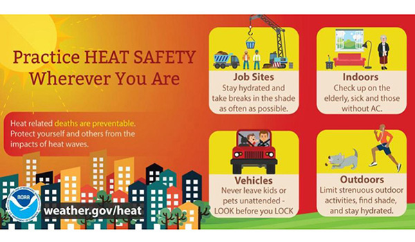
The first heat wave is the most dangerous as people aren't used to the heat yet! Make sure to take breaks and stay hydrated outside.
 
Image

Featured Post

Archival of Blogger and Move To Substack

Hello everyone, I'm making this post as a formal gesture that I have fully moved to Substack and will not be using this website anymore....