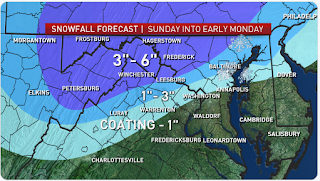
It's confirmed to snow on Sunday 3/3/2019. As of 10:10 AM, there's light snow flying out my window in Gaithersburg. It's coming earlier than expected. Could this mean a boom? Maybe. The question is, will it snow enough to close schools or delay? The snow amounts have to be
at least 3 inches to delay because if it's on the weekend, crews have much more time to clear the roads and an inch will be removed quickly. Temps in MoCo when the snow falls are hovering around freezing, so the snowfall rate would have to be heavy to stick to roads and sidewalks. Temps tomorrow is supposed to be below 40 degrees for all of MoCo, so a delay and closure is possible and is a pretty good chance. It's all snow for the upper quarter of MoCo(Damascus, Clarksburg). But the other 3 quarters, mainly the Bethesda quarter of MoCo, will mix with rain and sleet. The other 2 quarters
may mix with rain, but it wouldn't mix too much to decrease snow totals by a lot. A Winter Storm Warning is in effect for N&W MoCo with 3-6 inches of snow expected there. For South and Central MoCo, there is a Winter Weather Advisory in effect there. 1-3 inches of snow are expected in the advisory area. Both the Warnings and Advisories start at 12 PM Sunday 3/3/2019 and end at 4 AM Monday 3/4/2019. South and Central MoCo is mainly the most southern quarter of MoCo and the south part of the second quarter, not Gaithersburg. Gaithersburg is expected to get more snow than the most south quarter of MoCo. Let's go see the maps for our area for snow now!
Capital Weather Gang:
NBC 4:
NWS: MoCo is the snow gradient area here, which means the snow(colder air) is fighting the rain(warmer air). The more south you go, there's more mix and rain rather than snow. If you live in Southern and Central MoCo, you are in the snow gradient zone. 1-6 inches in MoCo.
WUSA 9: 3-6+ inches for 52% of MoCo with the other 48% in the 1-3 inches area.
ABC 7:
Fox 5:
Snowflake Predictions
Zachary's Prediction: 4 snowflakes
Accuracy Rate: 50%(he's only done 2 predictions)
"I have checked all of your sources, and I predict 3 - 5 inches of snow for lower Montgomery County and 4 - 7 for upper Montgomery County. So, I predict 4 snowflakes because remember, when they need to close for one part of the county, they have to close for the whole county."
My Prediction: 3 snowflakes(40% closure 60% chance of delay)
Accuracy Rate:85%
It isn't that much snow, but since highs on Thursday are below 40 degrees, melting will be slow. A delay would help the temps go up more and give more time for crews to clear everything. I don't expect main roads to be snow covered, but secondary and neighborhood roads could be snow covered, especially in upper MoCo. A closure is possible because of the snow amounts in Upper MoCo and the temps and the winter weather lasting till 4 AM, but I don't think so because roads should be okay for the most part. I think MCPS will call a delay and do a re-evaluation at 7 AM. If it booms, my snowflake prediction would be 4 snowflakes.


No comments:
Post a Comment