On Sunday, I knew that this storm was going to change a lot, and I was right. Unfortunately, the snow totals over the past 24 hours have decreased, and the chances of us getting double digits of snow are sadly low. However, this snowstorm is still significant, if you live north and or west of Rockville. MoCo is the snow gradient for this storm, but the rain/snow line is pushing up hard. However, here's the (potential) good news. This snow/rain line has been pushing up north, however, its very difficult and downright crazy to predict where the line is going to be. Although the trend seems to be the rain/snow line pushing north, we still really don't know the exact locations where it will stand. Tomorrow morning, in the early AM hours, we will have a much better idea of where exactly the snow rain line will be. The models can only be so accurate. So we could have the gradient go down a little bit.
The watches have turned into a winter storm warning for NW MoCo, and an advisory for southeast MoCo, which was expected with these totals dropping. However, I wouldn't be surprised if the warning extended to include all of MoCo, or the warning gets removed for NW MoCo and is instead replaced with an advisory. With the amount of pure snow dropping, and the amount of mix increasing, there comes another concern: Freezing Rain. There will be more freezing rain in southeast MoCo, however, it won't have as much as an impact compared to NW MoCo, even though they are predicted to get less freezing rain. The main reason for this is because of the temps. In NW MoCo, since the temps are lower, the freezing rain will start to form and accumulate in more areas compared to SE MoCo, where the freezing rain won't accumulate as much. I think that the freezing rain won't have much of an impact.
Enough of words, lets look at some maps!
NWS:
If you saw the NWS map today, you will see a big difference in the snow totals. MoCo is in the 2-8 inches of snow range. Let's break it down one by one. People who live in the borders of MoCo, right next to DC and PG's county, will see 2-3 inches of snow. People who live in southern MoCo(not border south) will see 3-4 inches of snow(Bethesda, Wheaton, Colesville, etc.). People who live in mid-county(Gaithersburg, Rockville, Montgomery Village), including most of Germantown, will see up 4-6 inches of snow, maybe a little bit more. People who live in upper MoCo(Clarksburg, Damascus, Barnesville, etc.) will see 6-8 inches of snow. You can see why the people in southern MoCo are in an advisory while mid-county and up are in a warning. Look at how different each region of MoCo is! A mile difference could result in huge snow amount differences.

For our county(and almost all of Maryland for that matter), the snow will be arriving at 11 AM - 1 PM, the more west you are, the more earlier. For everyone(in our county), it will initially start out as snow, then as we go into the afternoon hours, the snow will start to turn into a mix(the more south and east you are the earlier and longer the mix will last), and then maybe even some rain, and then as we proceed into the night hours, the mix changes back to pure snow, and heavy snow rates are expected to fall during the night. That's the general timing of this storm. However, with temps hovering below or above freezing, its going to be a mess.
Here are what the warning and advisory says:
"* WHAT...Heavy mixed precipitation expected. Total snow and sleet accumulations of 3 to 6 inches and ice accumulations of up to one tenth of an inch.
* WHERE...In Maryland, Northwest Montgomery and Northwest Howard Counties. In Virginia, Eastern Loudoun County.
* WHEN...From 7 AM Wednesday to 4 AM EST Thursday. Snow will overspread the area between 9 and 11 AM. Snow will change over to a mixture of sleet and freezing rain during the afternoon.
* IMPACTS...Travel could be very difficult. The hazardous conditions could impact the morning or evening commute.
* ADDITIONAL DETAILS...Visibility will be reduced below one-half mile at times in snow."
Advisory:
"* WHAT...Mixed precipitation expected. Total snow and sleet accumulations of 1 to 3 inches and ice accumulations of around one tenth of an inch.
* WHERE...Portions of central, northeast and northern Maryland and northern Virginia.
* WHEN...From 10 AM Wednesday to 1 AM EST Thursday. Snow will overspread the area between 9 and 11 AM, and change to sleet and freezing rain during the mid-afternoon.
* IMPACTS...Plan on slippery road conditions. The hazardous conditions could impact the morning or evening commute."

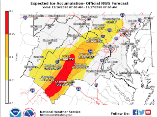
As you can see, with total snow amounts dropping, the potential for ice increase. Most of the county will see some sleet/freezing rain, but it won't be anything significant. As we go further west the ice potential and accumulation increases all the way to .5 inches of ice! I think this also includes sleet and graupel though. The snow will still probably be the main course for this storm, unless you live southern MoCo/areas below MoCo, where the mix may be more concerning than the snow itself.
Fox 5:
As you can see, the Fox 5 map... hasn't changed that much? About half of the county is in the 1-3 inches of snow range, and the other northern half is in the 3-6 inches of snow range. The blue area of snow(6-12 inches) is right above our county, so if you live in a more northern section of the county, you might see 6 inches or maybe a little bit more.
NBC 4:
NBC 4 is the most optimistic out of all of these maps, in which there is the highest snow range. 1/3 of MoCo(southern areas) are in the 1-4 inches of snow area, while the rest of MoCo is in the 4-8 inches of snow area. They say that areas like Gaithersburg and Fairfax will see 4-6 inches of snow, and areas like Damascus and north will get a lot of snow, with 8-12 inches of snow possible(Damascus still in 4-8 inches range but very close so I wouldn't be surprised if it exceeds 8 inches).
ABC 7:
This map is giving quite a large range for MoCo; 2-12 inches! 3/4 of MoCo are in the 2-6 inches of snow range, while the upper quarter are in the 6-12 inches of snow range. However, I don't think MoCo will receive more than 10 inches, let alone a foot, but I would love to be wrong. That wide range is really the only safe way to forecast because a slight difference in the rain-snow line could make a huge difference on how much snow we get. We want the line to move south/east so that more of MoCo gets more snow than mix.
WUSA 9:
I agree with this map much better than their old map, because in the old map, I thought they were overestimating the rain/snow line, however, the chances of the old map playing out is more likely than I would like. About 2/3 of MoCo is in the 1-3 inches of snow range, and the northern 1/3 of MoCo is in the 3-6 inches of snow range. Look at how close upper MoCo is to the 6-12+ inches of snow range. That proves that the gradient is MoCo, and suggests that the rain/snow line is somewhere in MoCo. There's not much else to say about this map.
The basic takeaways from this are:
- This storm is going to be messy and downright impossible to predict, especially in southern MoCo.
- The heaviest snow rates are between 1PM and midnight.
- Roads and sidewalks will be slick at almost all times, and snow will easily stick.
- Temps will be below freezing during the AM hours and will be hovering over 32 during the afternoon and evening hours.
- The biggest impacts will be north and west of MoCo, where some areas could see 18+ inches.
- Ice accumulation is not out of the game, and will likely happen during the evening/late afternoon hours.
- Most of MoCo might see some pure rain during the early night/late evening.
- We will fully switch back to snow after 8-9 PM.
That's all we know at the moment. When the snow starts to reach WV and Virginia, we will have a better idea of the snow/rain line and what will really go down.
What are the impacts? Well, since everything is virtual, it won't have much impact on school, unless there are widespread power outages, but there's not enough ice or snow to really cause that. On a normal day this would be 4 snowflakes, due to the snowfall rates and just the overall messiness(conditions would be too bad for an early release). However, any physical work will be shut down. Food distribution will be shut down until Thursday(confirmed), and any work in the physical office(like meetings) will be canceled and shut down. I don't think there will be a shutdown of virtual school though. I guess I will put it out there and say 1.5 snowflakes for school tomorrow, which means likely on time. Roads and sidewalks will be covered in areas above the beltway, at least somewhat. The temps will be cold enough and the snow will fall fast enough to stick, so you shouldn't think that it won't cause an impact on roads + sidewalks.You should cancel any plans for Wednesday, even if you live in the more southern areas of MoCo, because it will just be a huge mess. On Thursday, in the northern areas, it still won't be that great to go outside, and your plans should have some sort of delay or be straight up canceled, unless necessary.


No comments:
Post a Comment