We have gotten to the point in storm tracking, where instead of something might happen, something is probably going to happen. This event will be a long-duration event(probably not as long as the Jan 31-Feb 3 event though), lasting over 24 hours. This storm has a lot of potential to bring good snow to us, and possibly even increase our seasonal snow totals to become above-average(for a La Nina, that's pretty good)! However, we still have a lot that we don't know about. We don't know the exact amount that will fall, who sees what, things that we often don't know from this point out when we are looking at winter storms. The first part of this storm has gotten into the range of short-range models, but even with that being said, global models are our best bet at this very moment.
GFS:
As you can see, the GFS remains mostly all snow for us, with some mixing at times. There are 2 waves, Wednesday-Thursday, and then another wave on Thursday-Friday. It does show a dry period between the wave transitions. Temperatures will stay below freezing(on the ground) this entire time.
The GFS shows a widespread 7-14 inches, with more snow in the NE parts than the SW part, when this storm is all said and done. It has been caving towards the snowier, colder European model.
European:
The European Model shows non-stop heavy snow, without any break. This model is our best bet at the moment, and it is going bullish for this storm.
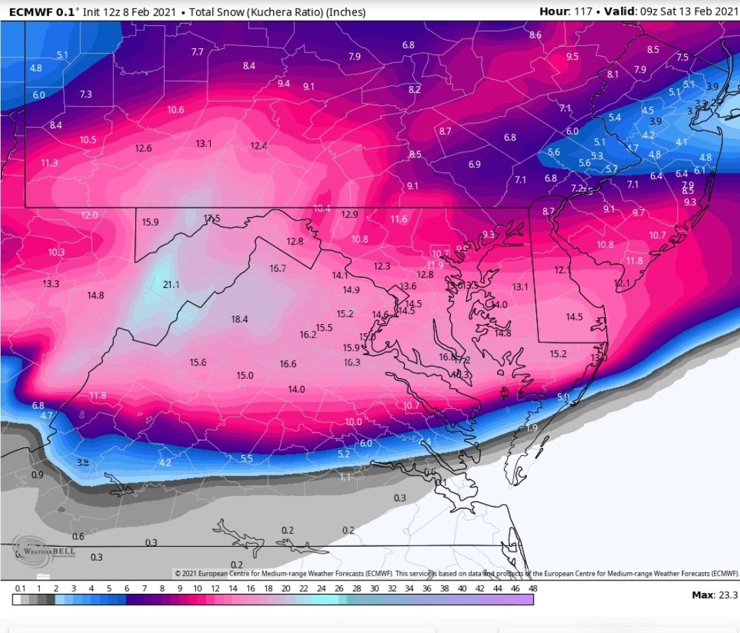
(Image from Weatherbell, someone who had access to it showed it to me). I wasn't kidding when I said the European model was going bullish with this storm. It shows
10 to 16 inches of snow! And it shifted this storm south as well. With the last minute NW trend(hopefully), this would make the DMV, and MoCo the bulleye of this storm! All of the ensembles show snow for us too, which is a good sign.
CMC(GEM):
The CMC shows the first part hitting us hard with heavy snow, but then shows the second part of the storm going to the south and missing us. However, due to the last minute NW trend, that part of the storm should go right up to us, making us the bullseye. It still shows some significant snow, even with the second part missing us, as you will see below.
The CMC shows 6-9 inches just from that first part, which is pretty good. As I said, I think the bullseye will shift NW, right to us.
The NWS has released their first call snow map. Note that they usually go conservative with totals at first.
The NWS says 4-6 inches for most of the county, and 3-4 inches for a part of Southern MoCo(most of it in 4-6 inches of range). And this only includes totals from Wednesday to Thursday(7 PM). We still have so more snow to go from Thursday night to Friday afternoon. The next part will probably drop at least 1-2 inches more. And I know that is what they are thinking because of the winter storm threats they have issued.
This is their storm threat for the first day(Wednesday-Thursday). They shows a medium confidence, low impact threat for both Southern and Northern MoCo, and a high confidence, low impact threat for the Alleghany Front. Snow is supposed to move in during the afternoon-evening hours, so the threat is understandably low. However, as you will see below, they think that there will be more of a threat on Thursday-Friday.
From Thursday to Friday, the NWS shows a medium impact, medium confidence winter storm threat for the entire region! The models show the bulk of the snow accumulation to be here. Temps won't rise above freezing the whole time.
My biggest concern is that the storm won't shift northwest, and will instead go to the south, giving us ample moisture. I don't think it will shift too north to the point where we don't get that much snow, that's much more unlikely than the storm staying south. The blocking in Canada will create a ULL to cross our region, ergo giving us a long-duration storm. This storm is mainly looking all snow, however sleet and ice are defintely on the table. I expect watches and warnings to be issued soon as we get closer to the storm. Right now, I would consider canceling any unesscary plans from Wednesday-Friday. Offices could close, but I won't make a prediction until tomorrow, cause I need more information. Snow will move in during the afternoon-evening hours of Wednesday, and will start to taper off Friday afternoon. These heavy bands will give us some good snow. As it is looking now, at least 3 inches is a good bet. I will make another post tomorrow and give more details.


No comments:
Post a Comment