Tuesday, January 12, 2021

Small Pattern Update

 So you know that pattern I was talking about at the very, very beginning of the year? Well, there's been a slight change, and I am going to make a small update on it.


As this tweet from Mike Thomas shows, the NAO in the very upper part of the world is going to get very negative, and the blocking will relax. That will allow the storm track to go up north to us! As I and a lot of other people have said, after the 13-16th, a winter storm threat will become more serious and likely. When the block relaxes, and "breaks down", this is when we have seen some of our better snowstorms in our area. The next week will be warmer than usual, but when we get to the end of this month and the beginning of February, we might see some cooling and get some decent cold air. That's all for now.

Saturday, January 9, 2021

January 12th Storm Update

Unfortunately, this storm has faded away, just like the 8-9th storm. It hasn't gone south, as far as I am concerned though, instead it just dissipated. The northern piece was too out of place for a phase to occur, and a phase is what we need for a snowstorm.  The next week doesn't look that great for any snow. However, after the 15th, then we have a good chance to see some good snowfall. The blocking will relax, which will allow the precipitation course(s) to go up north to us. I will be watching the models closely for a threat that could materialize. Stay tuned folks.

Wednesday, January 6, 2021

January 8th to 9th Storm Update and More Storm News

Unfortunately, the overhype about the first storm in this new, favorable pattern for snow has dissipated and gone to the south. The January 8th-9th storm missed our area and went to the North Carolina area. However, next week is very interesting and is very similar to what we saw in Mid-December, where we got a smaller storm on Monday and a much bigger storm on Wednesday. We have a threat to watch on 12-13, and then ANOTHER threat on the 15-16th. However, I personally think(after some research), that any storm before the 15th shouldn't be taken as seriously(not in terms of impact) because of the heavy blocking in the Arctic. Once the blocking cools down, then storms in that period of time will be more serious(not saying that we can still get serious storms before the 15th). I will be watching both threats. The models are showing mixed things for these threats, and since they are so far out, only the GFS and Euro model show precipitation for these time periods. As we get closer, I will start showing models.

Sunday, January 3, 2021

I made a Snowfall Tracker Page!

I made a snowfall tracker page! I had snowfall information, but it was only for me. I decided to release it to my dedicated readers and viewers so that we can compare our totals to what was predicted, or compare them to different locations! You can access it regularly like the way you can access other pages, it should appear on the top right, right below the "Search this blog" tool. Read the page for more information. I also published my winter forecasts post! Go check it out.

The Winter Forecasts

The Snowfall Tracker

The New Weather Pattern For The Entire USA

Winter Forecasts 2020-2021

 These are the winter forecasts for this winter! This post got delayed by a long time, and I sincerely apologize for that. I have been working on this post since November, but never decided to finish it. Now it's 2021, and the first significant winter snowfall has fallen already (4 inches of snow w/o sleet, 4.25 inches with some ice). However, other than that there has been nothing. These maps can still somewhat hold up. I hope you enjoy! Sorry if it seems rushed, I tried to wrap everything as fast as I could.


WUSA 9:


Most of MoCo is in the 10-20" snow range, and the most northern is in the 20-30", and the very southern part is in the 2-10" snow range. They predict a below-average snowfall season this year. However, places more north and west will see snow totals close to average snowfall. The reason why they think this is because this year its a La Nina. This is not good for snow lovers because this is what a La Nina does(in their own words):

"The northern branch of the Jet Stream, the storm track, is forced north of the Mid-Atlantic taking the storms to our west, which draws up warm air from the south resulting in rain and not snow. Snowstorms must track south and east to hold in the cold air."

For Bethesda, they predict 13" of snow(avg = 19"), and for Dulles(closest to the amounts the northern part of the county gets), they predict 18" of snow, when the average is 23". So their range is 11-22 inches of snow for the whole county. That's below average. However, they are saying we WILL get more snow than last year. They also predict above-average temps as well. We will still get arctic outbreaks time to time though. They predict that the first measurable snow will be on Dec. 16. 

FOX 5 DC:

The Fox 5 map shows 12-24 inches of snow for the upper half of our county, while the lower half is in the 7-17 inches of snow range. This means that even if you are in the 7-17 inches of snow range, you could potentially see more snow than someone in the 12-24 inches of snow range(unlikely though), because you could see 17 inches while they could 15 inches, for example. Like the other forecasts, they predict a snowier winter compared to last year's, but still below average, and above average temperatures.

NBC 4:


NBC 4 predicts a below-average snowfall this year. They say that we will have above-average temps this year, and the main reason we aren't getting as much snow as we used to, is because of climate change and the warm winters. In Maryland, winter is the season that is warming the most, according to NBC 4. They also said that we will have a La Nina winter, which is not a good setup for snowfall. The southern part of MoCo(1/3 of MoCo) is in the 4-10" snowfall range. The other parts of MoCo are in the 7-15" snow range. For MoCo, according to this map, I would say its range is from 5-15 inches of snow.

"Over the last 20 winters, 13 have had below-average snow levels," says Doug Kammerer. "The truth is, we are just getting less and less snow around here due to climate change and warmer winters," says NBC 4. NBC 4 says for some actual snow, we need cold air, but its all locked up in the north.

ABC 7:


ABC7 is forecasting below-normal snowfall this year. About 2/5 of the county(southern part) are in the 3-13 inches of snow range, while the other 3/5 are in the 8-18" of snow range. For our county, I would say we will be seeing 6-14" of snow this year. They also predict a La Nina, which is not great if you want an average amount of snow.


If you look at the chart closely, you can see that after 2010, the annual snow in D.C has been reducing by a lot. There are spikes here and there, but for the most part, they have been starting to go down. The main reason for that would be of warming temps during winter. For temps this year, they predict it to be above average. They see an season cold snap which will make December the coolest month compared to the average temps during winter. This increases the chance of having a white Christmas in Maryland/MoCo/DC (8-20% through MD). They don't expect low temps to go in the single digits or lower, for DC at least. They expect 11-14 degrees to be the coldest of the season, if we even get there. Personally, I feel the northern side of MoCo might be able to touch the surface of single digits, if it even gets that cold. 


My Prediction:

So what do I think? I personally agree with all of these maps, and predict a below-average winter, in terms of snowfall. I also think that it won't be too much below average, so like 1-3 inches below the average snowfall, and there will be more snowfall than last year. Temperatures will be above-average, this has been a trend for the past 5 years. Don't expect the most wonderland-like winter, but also don't expect a barren winter, where it's mostly dry of snow. 2021 Update: With the new pattern that has gotten the weather community on the east coast hyped for some crazy winter weather, I actually predict an above average winter, in terms of snowfall. We haven't seen this type of pattern in quite a while. Read more about it here: https://mcpsweather.blogspot.com/2021/01/winter-forecasts-2020-2021.html. I think that we can see some good winter storms this year, but you never know. Also, I am thinking, from next year onward, to create my own winter forecast maps, so comment on what you think of it! Should I make them, or should I do something else? Let me know. Thank you always, for the incredible support you have given. It really helps me to make the best posts I can.


Saturday, January 2, 2021

A new year, a new pattern, and a new storm potential!

Read the summary down below if you don't want to read the whole article; this weather news impacts people as far south as Florida and Texas. The first part is for DMV readers, though.


Happy new year to everyone! Hopefully, we can put back 2020 and move on. As the new year has come, we also have a chance of some snow, on Tuesday, and then something else to watch, during the time period of January 8th.
This tweet from the Capital Weather Gang says the chances for over an inch of snow (SPI) is 1/10, and the chances are rising. The Tuesday snowflakes part of the tweet is nothing too crazy to look forward to, but it is the last part of the tweet that is interesting, "next week as the pattern becomes friendlier for snow." 

This is the part that is for all readers, including the ones that aren't located in the DMV.

The pattern is important for winter weather, as it can decide how much moisture or cold air we get. Last year, we had the moisture but were just lacking the cold air. In the past 5 years, we haven't really gotten any storm that was crazy(With the exception of the 2015-2016 winter and maybe the 2018-2019 winter). This winter, for the entire U.S(as far as I am concerned), is a La Nina winter, which isn't good for snow in our area, because of the warm waters RIGHT next to the Atlantic. When the moisture comes(precip), there is warm air in place and there is rain. Right after, there is cold air, but no moisture. However, we can still see some above-average snowfall, even in a La Nina.

This map shows the pattern that will be coming in the next few days(Credit to Nikhil Trivedi for getting this picture, the picture was taken from his tweet.) If you don't understand this at all(like I do), the blueish colors represent the cold air. Due to anomalous ridging(which means that all of the warm air is in the Arctic air, or at least I think so), the cold air gets displaced and put to the south(Mid-Atlantic and interior southeast), which means we get cold air(certain about the pattern bringing cold air to us).  This means that places like Florida and Georgia could see some significant snow and winter weather! This is the same type of pattern that occurred during the epic and awesome winter of 2009-2010, where D.C alone almost measured 5 feet of snow and is the winter where we got the most snowfall recorded. (The interior Northeast didn't get much snow though that year). We got big, huge snowstorms and blizzards, that occurred next to each other(These storms were close to as big as the blizzard of 2016!). This could finally bring us the winter that we snow lovers in the Mid-Atlantic and Southeast have been waiting for for a long time. These kinds of storms and patterns could close schools, even through virtual learning! This is one of the most exciting things about winter weather I haven't seen in a LONG time. I know I am hyping this too much, but we have everything in place! Now... we just wait. The potential storm on January 8th is the first storm in this pattern. 

This picture, taken by Matthew Cappucci(a meteorologist for the Capital Weather Gang), explains this pattern much better. This shows that in the Northeast + Mid-Atlantic(most of it), there is increased winter potential for some good storms, and as the picture above also shows, cold air locked into most of Pennsylvania and down to include most of the southeastern and central USA. In the interior southeast(Georgia, Arkansas), there is also an increased severe weather potential for you guys(thunderstorms, tornadoes, etc.). And in the west coast, and the upper Midwest, the temperatures will be above average. There's also an active storm track coming, which is why we have a good bet on some good winter weather. Our area is above the storm track, which is good, since it means that we will be in the storm track. I will be watching that Jan 8-9 storm, and making posts about it soon.

Summary:

If you didn't read the entire article and just want a summary, there's a pattern in place for our area that will lock in cold air for the Mid Atlantic, the Southeast, and a good chunk of the central US. There will be increased winter potential for the Northeast and increased severe potential in the interior Southeast. The upper midwest and west coast will see above-average temperatures. The DMV could see some snowflakes on Tuesday, and there's a bigger storm on Friday-Saturday that will be the first storm of this new pattern. Right now, snow lovers around the east coast are rejoicing. Thank you for reading!

Thursday, December 24, 2020

White Christmas Update

So, nothing has really changed for the white Christmas possibility. We won't see over an inch of snow(unless you live far north and west or in the mountains), so we won't have an official white Christmas. However, today is going to be crazy in terms of weather. Right now, in the morning, there are just mild showers(rain showers). As the day keeps going, the rain becomes heavier, and we will start to see thunderstorms, some even severe. We will start to see downpours, that could possibly lead to flash flooding. We could even see some tornadoes in areas. However,  the most likely, and most concerning issue, will be damaging winds(40mph+ possible) and flooding. Our area is under a flash flood watch, which means we could see some dangerous flooding. When we go through the night hours, the severe, rainy weather will start to wrap up as temperatures start to drastically drop. And that folks, is our chance to see some snow. The more west and north you are, the more snow you will see, because of that cold front pushing through faster. And herein lies another big concern: Black Ice. It will have rained a lot by the time temps start to become colder, and there will be enough water on everything that there will be a flash freeze. What about the snow? Snow will easily start to stick as the temps drop. There won't be much snow, as I said before, in terms of accumulations. Some areas in our county may see a coating/dusting, but that's about it. The snow may continue into the morning hours of Christmas, but will most likely wrap up by the afternoon. For the week or so, it's going to be very cold. These are below-average temperatures for December and will feel even colder because we have felt a lot of above-average winter temps in the past 4-6 years(more than average or below average). The only danger I would say for Christmas would be the black ice, other than that I think it will be fine, at least weather-wise. Merry Christmas!

Tuesday, December 22, 2020

White Christmas Possibility?

 Recently, there has been a lot of talk going around about a white Christmas. This is... a pretty rare thing to happen in the D.C area, let alone DC. I think the last white Christmas in our area was in 2009/2010(excluding the mountains). I didn't want to post about this chance because I didn't want to hype everyone up, since a white Christmas is a very hard thing to bet upon. However, there is a decent chance that we will see snow fall on Friday(December 25th). Stickage will be difficult with highs in the 60s on Christmas Eve, so that's why an official white Christmas will be hard(1+ inches of snow). We could see a dusting in our northern areas, but that's about it in terms of accumulation. 


And some other good news: We have an active pattern for the month of January. We have frequent storm chances separated by cold(?), dry winter days. That means that we could see some good snow in January! 

Thursday, December 17, 2020

End of Storm

Now that the storm has ended, and our backend snow has ended too, I got a storm total of 4.25 inches. I heard that other people in MoCo got 1-3 inches, some getting 4. However, areas north and west got hit with the jackpot. I heard people getting 7-9 inches of snow, and some even getting over a foot. This storm wasn't a bust or disappointing, at least for me, because I had gotten 4+ inches. However, right now, it is so, so, dangerous outside. On a normal day, I would predict 3 snowflakes, due to how icy and slushy it is everywhere in the county. Snowplows came to my neighborhood over 8 times, and they got stuck one time. It is so slippery and icy outside, and the snow isn't much better too. Imagine a sandwich. The snow is the bread, both on the bottom and on top, and in the middle of the snow sandwich, there was sleet and ice. Cleanup will be very difficult, and temps aren't supposed to climb the upper 30's. And the regular rain washed away all pre-preparations(like salt and brine), so in places where the roads weren't supposed to be slick, they are now.

Overall, this storm was more of a mix for us than a snow event. However, in New York and New Jersey, it's really coming down there. I heard that they were expected to get over a foot of snow, some areas potentially getting over 18-24 inches. But for December, this was a good winter precipitation event! We don't usually see this kind of setup or this type of snow for December. The cause for this is that December is supposed to be the coldest month compared to its average temps. I am not saying that December is colder than January or February, January will be colder than December and will have better snow events. But compared to their averages, December is the month that is the most below average. What a great punch to the snow season! 4.25 inches so far. This is almost the same amount of snow I got totally from last year.

Wednesday, December 16, 2020

Snow Reports and Backend Snow

UPDATE: The backend snow is starting to push in as temps start to drop.  Our surface low is pulling away, which means that we should be cold enough to support snow/sleet. Read down below for more info.

What Happened in This Storm

This snowstorm started around 9 AM then the snow rate really started to pick up and become heavy at around 10:30 AM and lasted until 12:00-3:00 before the snow turned into a mix. It's now a mix for almost all of the county. So before the mix started, I measured about 4 inches of snow in Gaithersburg, and I have heard a range from 1-3+ inches of snow in MoCo. There is now freezing rain outside my window, and if it's raining but is below 32 degrees, that means that it is freezing rain. When I went outside, the conditions were so bad. There was a mess of ice, snow, and slush everywhere on the roads, even though snowplows and other help came in my neighborhood over 6 times. The plows got stuck at one point, but it was snowing so hard that the help eventually became useless(0.5+ inches of snow per hour) The ground is super slippery and dangerous, and objects that were outside were very slippery. Ice has become a huge concern now, and even after a lot of us switch to rain, a lot of us will switch back to a mix/snow, and temps will drop below 32 for EVERYONE, causing a massive and dangerous refreeze. Please do not travel unless it's necessary. If this was a normal day, a lot of buildings would be shut down. There is also a flood watch in effect for southern MoCo, as everything melting plus with rain will cause major issues with flooding. I have never seen this before in a winter storm. Temps are hovering around freezing as well, so it's very messy.


Backend Snow: 

Models are showing some backend winter precip, for Wednesday night and early Thursday AM, which is good for snow lovers like me, because snow will accumulate faster, due to low temps and no to little sun angle(it's night what do you expect?). If what they show happens, and the rain/snow line moves east/south, we could get 1-4 extra inches of snow, however, the models are showing more sleet than snow. We will see. The rain/snow line, according to the models, will more likely move east than south, which is still good.


Tuesday, December 15, 2020

Final Forecast for Wednesday-Thursday Storm

On Sunday, I knew that this storm was going to change a lot, and I was right. Unfortunately, the snow totals over the past 24 hours have decreased, and the chances of us getting double digits of snow are sadly low. However, this snowstorm is still significant, if you live north and or west of Rockville. MoCo is the snow gradient for this storm, but the rain/snow line is pushing up hard. However, here's the (potential) good news. This snow/rain line has been pushing up north, however, its very difficult and downright crazy to predict where the line is going to be. Although the trend seems to be the rain/snow line pushing north, we still really don't know the exact locations where it will stand. Tomorrow morning, in the early AM hours, we will have a much better idea of where exactly the snow rain line will be. The models can only be so accurate. So we could have the gradient go down a little bit.

The watches have turned into a winter storm warning for NW MoCo, and an advisory for southeast MoCo, which was expected with these totals dropping. However, I wouldn't be surprised if the warning extended to include all of MoCo, or the warning gets removed for NW MoCo and is instead replaced with an advisory.  With the amount of pure snow dropping, and the amount of mix increasing, there comes another concern: Freezing Rain. There will be more freezing rain in southeast MoCo, however, it won't have as much as an impact compared to NW MoCo, even though they are predicted to get less freezing rain. The main reason for this is because of the temps. In NW MoCo, since the temps are lower, the freezing rain will start to form and accumulate in more areas compared to SE MoCo, where the freezing rain won't accumulate as much. I think that the freezing rain won't have much of an impact.

Enough of words, lets look at some maps!


NWS:


If you saw the NWS map today, you will see a big difference in the snow totals. MoCo is in the 2-8 inches of snow range. Let's break it down one by one. People who live in the borders of MoCo, right next to DC and PG's county, will see 2-3 inches of snow. People who live in southern MoCo(not border south) will see 3-4 inches of snow(Bethesda, Wheaton, Colesville, etc.). People who live in mid-county(Gaithersburg, Rockville, Montgomery Village), including most of Germantown, will see up 4-6 inches of snow, maybe a little bit more. People who live in upper MoCo(Clarksburg, Damascus, Barnesville, etc.) will see 6-8 inches of snow. You can see why the people in southern MoCo are in an advisory while mid-county and up are in a warning. Look at how different each region of MoCo is! A mile difference could result in huge snow amount differences. 


For our county(and almost all of Maryland for that matter), the snow will be arriving at 11 AM - 1 PM, the more west you are, the more earlier. For everyone(in our county), it will initially start out as snow, then as we go into the afternoon hours, the snow will start to turn into a mix(the more south and east you are the earlier and longer the mix will last), and then maybe even some rain, and then as we proceed into the night hours, the mix changes back to pure snow, and heavy snow rates are expected to fall during the night. That's the general timing of this storm. However, with temps hovering below or above freezing, its going to be a mess.

Here are what the warning and advisory says:

"* WHAT...Heavy mixed precipitation expected. Total snow and sleet accumulations of 3 to 6 inches and ice accumulations of up to one tenth of an inch. * WHERE...In Maryland, Northwest Montgomery and Northwest Howard Counties. In Virginia, Eastern Loudoun County. * WHEN...From 7 AM Wednesday to 4 AM EST Thursday. Snow will overspread the area between 9 and 11 AM. Snow will change over to a mixture of sleet and freezing rain during the afternoon. * IMPACTS...Travel could be very difficult. The hazardous conditions could impact the morning or evening commute. * ADDITIONAL DETAILS...Visibility will be reduced below one-half mile at times in snow." 

Advisory:


 "* WHAT...Mixed precipitation expected. Total snow and sleet accumulations of 1 to 3 inches and ice accumulations of around one tenth of an inch. * WHERE...Portions of central, northeast and northern Maryland and northern Virginia. * WHEN...From 10 AM Wednesday to 1 AM EST Thursday. Snow will overspread the area between 9 and 11 AM, and change to sleet and freezing rain during the mid-afternoon. * IMPACTS...Plan on slippery road conditions. The hazardous conditions could impact the morning or evening commute."


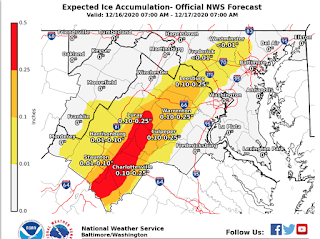
As you can see, with total snow amounts dropping, the potential for ice increase. Most of the county will see some sleet/freezing rain, but it won't be anything significant. As we go further west the ice potential and accumulation increases all the way to .5 inches of ice! I think this also includes sleet and graupel though. The snow will still probably be the main course for this storm, unless you live southern MoCo/areas below MoCo, where the mix may be more concerning than the snow itself.


Fox 5:


As you can see, the Fox 5 map... hasn't changed that much? About half of the county is in the 1-3 inches of snow range, and the other northern half is in the 3-6 inches of snow range. The blue area of snow(6-12 inches) is right above our county, so if you live in a more northern section of the county, you might see 6 inches or maybe a little bit more.

NBC 4:

NBC 4 is the most optimistic out of all of these maps, in which there is the highest snow range. 1/3 of MoCo(southern areas) are in the 1-4 inches of snow area, while the rest of MoCo is in the 4-8 inches of snow area. They say that areas like Gaithersburg and Fairfax will see 4-6 inches of snow, and areas like Damascus and north will get a lot of snow, with 8-12 inches of snow possible(Damascus still in 4-8 inches range but very close so I wouldn't be surprised if it exceeds 8 inches). 


ABC 7:

This map is giving quite a large range for MoCo; 2-12 inches! 3/4 of MoCo are in the 2-6 inches of snow range, while the upper quarter are in the 6-12 inches of snow range. However, I don't think MoCo will receive more than 10 inches, let alone a foot, but I would love to be wrong. That wide range is really the only safe way to forecast because a slight difference in the rain-snow line could make a huge difference on how much snow we get. We want the line to move south/east so that more of MoCo gets more snow than mix.


WUSA 9:

I agree with this map much better than their old map, because in the old map, I thought they were overestimating the rain/snow line, however, the chances of the old map playing out is more likely than I would like. About 2/3 of MoCo is in the 1-3 inches of snow range, and the northern 1/3 of MoCo is in the 3-6 inches of snow range. Look at how close upper MoCo is to the 6-12+ inches of snow range. That proves that the gradient is MoCo, and suggests that the rain/snow line is somewhere in MoCo. There's not much else to say about this map.

The basic takeaways from this are:
  • This storm is going to be messy and downright impossible to predict, especially in southern MoCo.
  • The heaviest snow rates are between 1PM and midnight.
  • Roads and sidewalks will be slick at almost all times, and snow will easily stick.
  • Temps will be below freezing during the AM hours and will be hovering over 32 during the afternoon and evening hours.
  • The biggest impacts will be north and west of MoCo, where some areas could see 18+ inches.
  • Ice accumulation is not out of the game, and will likely happen during the evening/late afternoon hours.
  • Most of MoCo might see some pure rain during the early night/late evening.
  • We will fully switch back to snow after 8-9 PM.
That's all we know at the moment. When the snow starts to reach WV and Virginia, we will have a better idea of the snow/rain line and what will really go down.

What are the impacts? Well, since everything is virtual, it won't have much impact on school, unless there are widespread power outages, but there's not enough ice or snow to really cause that. On a normal day this would be 4 snowflakes, due to the snowfall rates and just the overall messiness(conditions would be too bad for an early release). However, any physical work will be shut down. Food distribution will be shut down until Thursday(confirmed), and any work in the physical office(like meetings) will be canceled and shut down. I don't think there will be a shutdown of virtual school though. I guess I will put it out there and say 1.5 snowflakes for school tomorrow, which means likely on time. Roads and sidewalks will be covered in areas above the beltway, at least somewhat. The temps will be cold enough and the snow will fall fast enough to stick, so you shouldn't think that it won't cause an impact on roads + sidewalks.You should cancel any plans for Wednesday, even if you live in the more southern areas of MoCo, because it will just be a huge mess. On Thursday, in the northern areas, it still won't be that great to go outside, and your plans should have some sort of delay or be straight up canceled, unless necessary. 

Featured Post

Archival of Blogger and Move To Substack

Hello everyone, I'm making this post as a formal gesture that I have fully moved to Substack and will not be using this website anymore....