Friday, April 30, 2021

Wind Storm Update + Nowcast

5:55 PM:

This area of precip is about to hit MoCo. You may see some downpours, and probably some really gusty winds. It will have to be closely watched. I see up to 50 DBZ in this area, but you will start out with low rate precip.


5:30 PM:


This area of precipitation moving (south)east needs to be watched carefully. Winds could be enough to deem this severe. It isn't a small amount of precip either. Radar is still filling in with precip(LWX radar). This area of precip could hit MoCo and DC. 


5 PM:


The severe thunderstorm warning for Germantown will be allowed to expire at 5 PM. However, the thunderstorm warning continues for Southern MoCo. Penny sized hail and 70 MPH winds possible.


4:50 PM:


SEVERE THUNDERSTORM WARNING FOR ALL OF MOCO! 60 MPH WIND EXPECTED AND PENNY SIZE HAIL POSSIBLE! GET INSIDE, STAY AWAY FROM WINDOWS, AND SEEK SHELTER NOW! THIS IS A LIFE THREATENING EMERGENCY!!


4:25 PM:


These are the peak winds recorded so far. The winner is Petersburg, with a gust of 62 MPH. You can see most of the region has at least 40 MPH winds and theres a good amount who saw over 50 MPH winds. These numbers may increase.


4:10 PM:


At this point of time, we are in the height of the storm, in peak wind(wind will be sustained throughout the evening). So much damage reports are coming in, including fires caused by downed power lines. Around 3000 people are without power in MD, with more to come as the night goes on. Some roads will be blocked. Lots of wind reports at 50-60 MPH. 
This line of showers may contain pea size hail(0.25" hail) and 50-55 MPH winds. This will make the situation worse. It's right now hitting Washington County and Winchester, and may hit Frederick County, Loudoun County, and MoCo. Lots of reports of pea size hail with this line of showers.


2:30 PM:

Throughout the region right now, widespread wind gusts of 45-60 MPH are being observed. Isolated wind gusts that are higher than right now are possible through the evening, and a wind gust of around 70 MPH cannot be ruled out in Northern Maryland's higher elevations. Scattered shower activity will peak this evening, and thunder + small hail are plausible and can't be ruled out because of cold mid levels.  Lows in the 40s with wind chills in the 20s are expected tonight.
- Paraphrased from Forecasters Discussion

1:50 PM:


These are the latest recorded wind gusts. As you can see, the highest gust so far is 58 MPH in Cumberland. In MoCo, 48-50 MPH gusts are being recorded. We are approaching peak wind time, which should be around 3-5 PM. Winds are starting to really pick up everywhere, and sustained winds are also rising too. A lot of downed tree reports came in at the same time, and with sustained winds plus wind gusts, trees and power lines will become weak and even fall. Already some pretty good wind damage here. Lots of tree logs(>3") have fallen and been blown away.


12:25 PM:


In the past hour or so, the wind reports have been exploding like crazy. Someone has also died from this event. A tree fell on their vehicle. Many reports of downed power lines and fallen trees. In MoCo, a tree fell and caused an accident with 3 injuries(I-495/Beltway Outer Loop After I-270). It's getting really bad out there. And the worst part? We aren't even at peak winds yet. In the next hour or two, we will reach peak winds. The max wind gust reported in Maryland was 54 MPH in Thurmont. The highest recorded so far in the DMV is 57 MPH in Kline Gap, WV. Outages are rising. Around 2300 in Maryland and 230 in MoCo. Please stay safe everybody!


10:10 AM:

Already some tree damage occuring. Lots of twigs and logs have been broken and fell on the ground.


9:50 AM:


The high wind warning has been extended to include all of MoCo, Loudoun County, DC, PG county, and the Shenandoah Mountains. 25 - 35 MPH sustained winds are expected with gusts up to 60 MPH. There is high confidence of a stronger wind field and long duration of wind. The warning is until 2 AM Saturday EDT. The strong winds will result in widespread tree damage and power outages. And, some reports are already coming in. We aren't seeing peak winds yet, too!

As you can see, there are multiple wind reports across the DMV. In NE Fairfax County, there is a report of downed wires. In SW Cecil County, there is a report of a tree fallen onto the ground. These reports are going to start to explode as winds pick up.

Thursday, April 29, 2021

High Wind Watch Upgrade and Advisories

 The high wind watch got upgraded to a warning for our northern areas, and almost all of the DMV(other than northern areas) are in a wind advisory. Let me show you the map.

Areas in the light blue/cyan are in a freeze watch(not our area). Areas in the light brown are in the wind advisory(includes DC, Southern MoCo). Areas in the orangish-brown are in a high wind warning. In the high wind warning, you can expect northwest winds sustained at 20-35 mph with gusts up to 60 mph. In the wind advisory, expect northwest winds sustained at 20-30 mph with gusts up to 55 mph. For areas in the high wind warning, widespread power outages are expected, winds will blow down trees and power lines, and travel will be made much more difficult for high profile vehicles. If you are near the high wind warning(less than 2 miles away), I would recommend preparing for the same impacts as areas in the high wind warning. You may even see winds that of those of the high wind warning. In the wind advisory, isolated power outages may occur, and tree limbs + unsecured objects may be blown around. No matter where you are, it will be bad regardless. 

What about school? The whole county isn't under a high wind warning but the northern part is, and if one part of the county closes, the other has too. Will we see in-person people going virtual, or even no virtual instruction? That depends on how much power outages there are, and if the winds will be strong enough to cause widespread power outages. The last time school closed for high wind was in March 2nd, 2018, where wind gusted up to 80 mph in some areas(up to 70 mph was expected)! At it's peak, over 500k people in our area did not have power! It was quite crazy. We had sustained winds of 20-30 mph winds that day, and similar sustained winds are expected, with slightly more potential. I am not sure if there will be strong enough winds to recreate that large of an impact. However, trees and power lines have already taken quite a beating this year from other storms, from severe storms to winter weather storms, with ice and snow pilling on the trees and wearing them down. We have also had many wind advisories this year, as an addition. A lot of my trees in my neighborhood have had to been cut or have been visibly worn down. I think there is a 50% chance for in person to be canceled and everyone to go all virtual. However, the chance for no virtual instruction is lower. I would place it at around 45% right now, but it would be 45-50% if I could choose a range(I will play it conservative for now). The 2018 event had high wind warnings for the entire region, and it was expected to be worse, with stronger winds. It's gonna be hard to choose. The wind event now is expected to come in 2 waves: one Friday afternoon, one Friday evening. They will be the strongest at this time. This will make dismissal difficult for in person students. I'm not really sure. I think if there is enough power outages there could be no virtual or in person, but it's too difficult. It's really just 50/50 for both options.

TL;DR I think there is a 50% chance for in person to be canceled and for all virtual, and a 45-50% chance for no instruction at all. Read above for the exact explaining. 

*Edited by QuackyDucc

Severe Threat Today and High Wind Watch

 Not only is there a severe threat today, but there is also a high wind watch for strong winds coming in with the cold front that will be moving through. Today is a marginal risk day for strong, potentially damaging winds from strong to severe thunderstorms.

As you can see, areas just north of DC are in the marginal risk for severe thunderstorms, and the main threat from these thunderstorms will be strong, potentially damaging winds and heavy downpours. The greatest risk will be from 2-10 PM tonight. Areas in the light green may see thunder/lightning, but storms there aren't expected to have strong enough winds to deem them severe. 

Areas in the green have a 5% chance to see 65 mph or greater winds 25 miles away from any given point. As stated before, this is mainly a wind threat, and not a tornado or hail threat.


This is a sounding from the NAM, and it's decent. The CAPE and shear are not too great, but there would be enough for a isolated thunderstorm.

At the same time(hour 9), at around 5 PM EDT, this is the amount of lift there is, and I must say, there is a pretty good amount! Clouds will be limiting instability at the moment though. This will provide for some isolated T-Storms that may or may not be severe.

FROM THE SPC:

"Confidence is low across most of the MRGL risk area for robust thunderstorms. However, there is considerable diversity across the ensemble of available 12z CAM solutions, with most areas showing promise for a strong storm or two in at least one member. Therefore will maintain the ongoing risk area and hope for better clarity in the afternoon outlook update." There hasn't been much changes in the forecast, and the some members of the ensembles show indicators for strong storms in most of the marginal risk areas. 


Now, for the high wind watches across the region. Areas highlighted in the brownish-orange color are under a high wind watch, which are mostly areas north of DC and areas east of Allegany County. There is potential for wind gusts to reach 60 MPH. This high wind watch is from Friday morning to (late) Friday night. The wind direction will be northwest, which will bring in cold air and signify a cold front. The highest, gustiest winds may occur in 2 waves, one Friday afternoon and one Friday evening. These winds could blow down trees and power lines, creating the potential for widespread power outages. Travel could be made much harder. This may be upgraded to a warning.

A high wind warning in 2018 was able to close school for a day. Will it happen again? Well, I'm not so sure. During 2018, gusts were recorded up to 75-80 MPH, and we are only talking about around 60 MPH gusts in this situation. And this is only a watch. I think there would have to be stronger winds to warrant a higher chance of closure for in person and potentially virtual. Right now it's undecided. I need more data and need to get closer to the event to even try to make a prediction. And it would have to be upgraded to a warning. Right now, I would assume that there would be school for mostly everyone, but we will see. I will make a new post in the evening with more data to try to make a prediction. Until then, stay safe, and I'll see you in the next post! Thanks for reading. 


Wednesday, April 28, 2021

New Severe Thunderstorm Format Taking Effect Today


This will be a short post explaining the new format of severe thunderstorm warnings. They will now have impact based warning tags. A severe thunderstorm(regardless of rating) is a storm that produces 58 mph or gustier winds and/or 1" or larger hail. If a thunderstorm has 58-70 mph winds and/or 1-1.5 inch hail, there will be no new tag and it will not be sent out to the public in any different way compared to before April 28. If there are 70-80 mph winds and 1.75-2.5" hail, there will be a new tag to the warning: considerable damage threat. However, they will not be released to the public any differently compared to before April 28. If there are 80+ mph winds and 2.75" or greater sized hail, there will be a new tag on the warning: "Destructive Damage Threat". If this occurs, this will be released to the public through smartphones using the WEA(Wireless Emergency Alert) using the IPAWS(Integrated Public Alert and Warning System). This system will hopefully help people better understand the severity of the thunderstorm when it comes to them, and gives them a better incentive to act properly based on the situation. Thank you for reading, and I'll see you next post!


Saturday, April 24, 2021

Late-April Snow in the DMV??

 Yes, you read the title right, snow fell in late April this year for parts of the DMV. And, its not just western and northern Maryland. There were reports of snow around DC(Arlington) and Baltimore + DC Metro. Some reports of snow possibly even in Baltimore City! It happened the night of April 21(as the cold front pushed through) and throughout April 22. In MoCo, here, I was able to record snow as well. And I was able to see it fall too. Last year, I saw snow in May, but this is also pretty rare. On the same days, frost advisories and freeze warnings impacted the region. On April 21, Baltimore got close to breaking its low record of 32F. Although I couldn't find reports, radar showed snow showers hitting MoCo and surrounding areas multiple times, and that probably means that there was snow in MoCo apart from just me.

This was my video of snow falling. If you look closely, you can see a small part of snow falling. I can confirm this. It didn't melt the instant it reached the ground, and stayed for a couple seconds before eventually melting. Pretty crazy day! We usually dont get snow this deep into April. Winter should pretty much be over after this weekend for a lot of the eastern US. You might have noticed there aren't much blog posts coming out, and that's because there really isn't much going on in the DMV weather world right now. May and June will probably be more interesting because of severe weather, but we will have to wait and see. Until then, enjoy the nice weather, and I'll see you in the next blog post! Oh, and a winter recap is coming around May.


Wednesday, April 21, 2021

Freeze Warning for Northern Areas + Severe Risk for Eastern Areas

Most of the DMV doesn't have a severe risk that could be rated by the SPC except for our eastern areas, who are in the marginal risk. Our western areas don't have any risk at all(not even TSTM, general risk for non-severe thunderstorms), but DC and most of MoCo are in the TSTM area(non-severe). Some of the Eastern Shore and Delaware are in a slight risk. But they aren't in our region(LWX). There is also a freeze warning for our northern and western areas. Temps will get to or drop below 32 in our northern areas, including Northern MoCo(the freeze warning isn't for northern MoCo though). The cold front is passing through, and it will be very windy. Although you may have gone out the day with a light jacket, when you come back in the afternoon, you're gonna need a winter jacket! It will be really chilly by the time the sun sets. Temps are dropping fast. North/northwest winds are gonna be pulling in cold air, indicating a cold front moving through. And it's already showing its effects. In southern Maryland, temps dropped from the mid 60's to 51 degrees in less than 2 hours. Once the sun has set, it's gonna get colder faster, and areas will drop below freezing at times. Let me show you some maps.

These are the current events happening. The dark purple represents a freeze warning. Elsewhere, there is a hazardous weather outlook. There are some severe thunderstorm watches/warnings, but that's only for the Eastern Shore.
As you can see, most of our region is either in the general risk or nothing. DC and most of MoCo(except for northwestern MoCo) is in the general risk for non severe thunderstorms. Our eastern areas are in the marginal risk, and thats the only exception.


Areas in the green have a 5% chance of seeing 1"+ hail 25 miles away from any point.

Areas in the green have a 5% chance of seeing 65+ mph winds 25 miles away from any point. Areas in the yellow have a 15% chance of seeing 65+ mph winds 25 miles away from any certain point.

And yes, there is still a chance to see snow tomorrow. However, as stated in the previous post, if there is snow, it will be very isolated and localized. There will be frost and a freeze tomorrow, especially in our northern and inland areas. During the night, northern and western will drop below freezing. This gives a higher potential for snow to materialize, if there's precipitation. Don't count or bet on it yet though. I will be doing a winter recap sometime this May.


Tuesday, April 20, 2021

Possible Severe Weather Tomorrow

 There is a possible severe threat tomorrow for most of our region. The SPC has issued a marginal risk(for severe thunderstorms), and a general risk of thunderstorms for our western and northern areas. Most of MoCo is in the marginal risk. The main threat is for damaging winds. Pea sized hail is also possible with these thunderstorms, but it's mainly wind. A cold front moving through the area will create the potential for strong, and potentially severe thunderstorms. After the cold front has moved through and temps have dropped enough, there is some possibility of; SNOW?! Say it isn't so?? Yes, in all seriousness, there is a chance for some very isolated, localized snow showers/flurries while temps are close to freezing. This is mainly for very late Wednesday night - Thursday morning (any chances after 7 am has a much less chance of happening due to sun angle and temps rising, it's still possible though, just much less likely). However, don't bet on it. It has a pretty good chance of not happening. Even if it does, it may be mixed with rain or another type of precip. It won't stick to anything, except mainly grassy areas, if there is stickage in the first place. The highest chance of stickage will be in Northern MD, but even there, the stickage will be on the grass. More into that later.

The dark green is the marginal risk for severe weather. Most of our region is in the dark green, while our western and northern areas are in the TSTM risk(general risk of non-severe thunderstorms).
Areas in the green area have a 5% chance to see 65+ mph winds 25 miles away from any point. Isolated strong thunderstorms, some possibly being severe possibly producing damaging winds and maybe evens small hail.

From the SPC: "Convective development is forecast to occur in lee of the Appalachian crest relatively early in the period, from eastern PA southward across central VA. Only modest instability (at or below
500 J/kg mixed-layer CAPE) is expected ahead of the advancing front, with storms to remain relatively low-topped across the region. Still, with linear forcing along the front, and fairly strong
west-southwesterly flow through the cloud-bearing layer, a few stronger -- possibly damaging -- wind gusts may occur within what should evolve into a semi-continuous band/line of convection. This convection should move off the Mid Atlantic Coast and into southern New England by late afternoon, weakening as it crosses MA/CT/RI and vicinity through the evening." For those who don't understand what they are saying, although theres not much instabillity in the atmosphere(key ingredient in severe weather), linear forcing along the front + somewhat strong (south)westerly flow through the cloud bearing layer may cause stronger, maybe even damaging wind gusts.


This is the NAM(12km, 18z run) at hour 27(5 PM Wednesday), and it shows a good amount of shear in the atmosphere. Most of the region is above 60kt(around 69 MPH) (except for western Maryland), and a lot of our region is also over 65kt(75 mph) in shear, and some of our region is even reaching around 70kt(80 mph) or higher! This is in terms of shear in the atmosphere. There is a good amount of shear in the atmosphere. At this time, all of the region is under 50 CAPE(instability) and there isn't much lift + moisture(<50% for a lot of the region) either. You need a good amount of these ingredients for severe weather. This map proves that this is mainly a wind threat.
This is the NAM(12z run, takes in data) sounding does indeed show snow for Northern MoCo at hour 45, around 4 AM EDT. This is a good sounding, with north/northwest winds  up until around 500 mb into the atmosphere, where it switches to more west. The dew point is below freezing. The dew point is the measure of moisture in the atmosphere, and doesn't determine whether or not snow will fall. However, it is a small indicator. It is also an indicator that the air is somewhat dry, and that snow showers/flurries will be isolated. The dew point starts to get around 30-34 around 700-900 mb, before lowering at 700 mb. The temp is 34 at the surface, but is a good amount below freezing for the rest of the atmosphere. The atmosphere would be cool enough the whole time that it would be able to snow on the ground, even above freezing. There is no sun angle concerns at this time(4 am), plus if it snows, the temp can quickly drop. Since the temp here is so close to 32, I wouldn't be surprised if places reach 32 or maybe even lower due to dynamic cooling, if the isolated bands set up. Don't count on it, since its so isolated. No model can really pick up on this. Close range HRRR may be able to help, but even then, the only way we can be sure is using radar. All there is is a chance for some flurries/snow showers. Don't get your hopes up for snow. Severe weather is also likely to be isolated.


Thursday, April 15, 2021

Cicada Invasion this Year?

 Yes, you read the title right. Unfortunately, once soil temperatures reach 68 degrees 8 inches into the ground, billions of cicadas will start to emerge from the ground and invade the DMV area. We are being affected by Brood X cicadas this year.

The darker orange areas are where the cicadas will be invading in this year, 2021, while the lighter orange/brown areas are where they have invaded historically. And in DC, soil temps are already becoming very close.
This tweet from Ryan Miller says that cicadas will start to emerge soon when temps reach 64 F at a depth of 8 inches.
Then, he shows a photo of a thermometer measuring a soil temperature of 63.6 F. And it's already started in some places.
This was a photo from Springfield, VA(Fairfax County), and it shows cicadas already starting to emerge from the ground. I would be confident enough to say that in our southern areas, there are already a good amount of cicadas starting to emerge. I haven't found any reports besides this photo though.
This is what happened during the cicada invasion of 2004(it affected our area). Some started to come out in mid-April, and then when May arrived, they really started to boom, and then they started to fall after early- June.


So, when will the rest of the cicadas emerge throughout the DMV area? Well, although some of them are starting to emerge in areas, they won't really start to explode and invade until May, as stated by the Capital Weather Gang. We have a few more weeks before we really start to see them everywhere. Temps in the next 10 days will be in the 50s and that means that soil temps will cool, delaying the main arrival of cicadas. There will be some early ones coming out, but as stated before, they won't really take over until May.


Sunday, April 11, 2021

Severe Weather Today

7:52 PM:

SEVERE THUNDERSTORM WARNING FOR WESTMINSTER, ELDERSBURG, AND REISTERSTOWN! GET INSIDE NOW!

7:40 PM:
The circled area are the next set of bands to watch. Some of them have pink colors, indicating possible hail and damaging winds. More squall lines are forming as we speak.

7:33 PM:

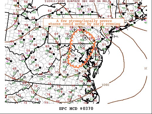
I didn't even notice this, but a lot of our region is in the circled area for the chance of some strong, and locally severe thunderstorms to occur by early evening! This means that the NWS and SPC is closely watching our area for some strong/severe storms.

7:30 PM:

As the band moves northeast of MoCo, another band is moving in northeast, MoCo right in its path. The. squall lines I circled need to be watched. I just recently heard thunder, and these bands may contain hail, with the dark red and light pink. More bands are coming in, this threat isn't done just yet.

6:42 PM:


Many squall lines, possibly thunderstorms, with some hail possible are moving northeast to MoCo and the DMV. As you can see, they have very heavy precip, up to 50-60 dbz with up to 70 dbz.  However, any pink/purple would more likely be hail, and we are seeing it in some of these bands. None of the areas in the path of these bands have been warned for a severe thunderstorm, so there might not be hail with it.

5:13PM:

I can report the sun has come out. Clouds starting to dissapate.

5:03 PM:

I've been observing the weather for the past hour, and for the past 30 minutes, the sun has not come out at all and the clouds have mostly taken over. There are still some blue patches in the sky, but they are generally small.

3:55 PM:

Clouds starting to really take over and kick in, and a lot of them are dark. Sun still managing to shine, but from time to time, clouds will cover the sun, and not much light will come through, and then the sun will come back out again. And the same thing happens over and over again. The sun has heated up the atmosphere and increased instability, which gives us a higher chance for more severe weather, and for it to be worse.

There is a severe weather threat for today. Most of our region is in the marginal risk except for our far western areas. The main threat here are hail and damaging winds.

Areas in the green has a 5% chance of seeing 1"+ hail or larger 25 miles away from any point.

Areas in the green have a 5% chance of seeing 65 mph(55 kt) or higher speeds of winds 25 miles away from a certain point. This threat will not mainly be a tornado threat.

This is a sounding from the 15z HRRR, at around 5 pm EDT. It shows possible hail ranging in size from 0.75-1.25 inches. It shows the possible hazard type as "Marginal Severe". The critical angle is 45, which isn't favorable for tornado development. It shows 690 MLCAPE(instability in the atmosphere) and 1021 CAPE at the surface. In most areas in our region, the sun has been out since this morning, and will continue to stay so for the next 1-2 hours. Clouds will start to increase. This isn't good in our situation, because the sun will heat up the atmosphere and ground, which will cause more instability. The dew point is 53 and the temperature is 75(at the surface). You would generally want dew points to be 60 or higher for more moisture, which will create the potential for more severe weather. 53 is still a high enough temp for severe weather though.

This is MLCAPE for the region around 5pm. The most is up to 1500 MLCAPE. A lot of the region is at or over 500, which is enough to cause severe weather.

The shear around 5 pm isnt the greatest. Its around 10-30 kt, with some areas getting up to 50 kt. You want at least 30 kt between the surface and 500 mb(around 6km into the atmosphere) to get support severe weather. In our northern areas, the shear is more to support severe weather.
The lift around the region is up to -6 C in our northern areas. Other areas have a lift of negative one to negative 3 lift(C). This can easily start the life of a thunderstorm if the lift is higher. We have decent moisture as well. 
FROM THE SPC: "A lead shortwave through is rotating northeastward over the Mid-Atlantic as of midday, with little forcing for ascent (or weak subsidence) in its wake. Given surface heating and lingering low-level moisture along and ahead of a cold front, a few storms may still develop this afternoon, with the more probable area from VA into south central PA. There will be marginally sufficient vertical shear and buoyancy for a low-end threat for damaging winds and/or large hail with the strongest storm this afternoon/evening." They are trying to say that a few storms may develop this afternoon, from VA into south-central PA. There will be enough shear and buoyancy for a threat(low-end) for gusty, damaging winds and or large hail, with the strongest storms around 3/4-7 PM. This is a hail and wind threat, not a tornado one. I will update this post with live updates as more information comes in.


Friday, April 9, 2021

Possible Severe Weather Today

There is a severe weather risk for our western regional, and the main threat is damaging winds and small hail. Most of our area is in the general threat area, where non-severe thunderstorms are expected, and possibly thunder or lightning.

The area in the marginal risk have a 5% chance of seeing 1 inch hail or larger 25 miles away from a certain point. 

The area in the marginal risk has a 5% chance of seeing damaging(65 mph or more) winds 25 miles away from a certain point. 

Overall, this threat shouldn't be that large for severe weather, and most places will just stay as drizzle and at the expected most, a non-severe thunderstorm with lightning and thunder. I already have a thunderstorm with lightning and thunder occurring right now(4:45 PM EDT). No hail or damaging winds, moderate - heavy rain.
4:50 PM EDT Update:
Thunderstorm mostly over, either no precip or drizzle just falling now.


Wednesday, April 7, 2021

April Fools Storm Recap

In the morning, there were reports of mixed rain and snow for the northern part of the region and possibly some stickage in northern Frederick and Caroll counties. Throughout the day, north winds and bands from PA brought graupel, sleet, and mixed rain and snow throughout a lot of the region. Then, after 3 PM, bands were forming that had less mixing in them and more snow. Then, at 4-5 PM, a band formed that mostly pure snow and brought heavy precip rates for a lot of the part of our region! Snow was reported as far into parts of Southern Maryland! Thundersnow/graupel was reported, which is really rare(0.07% chance in snowstorms), and especially cause it is in April! Stickage was reported in some parts of our northern region, and I was able to get a dusting/coating of snow, which is often recorded as 1"! Some people saw snow in temps as warm as 45-50+! It dropped from 44-42 in less than 5-10 minutes to 39 for me! Visibility dropped to <0.50 miles! That shows you the power of dynamic cooling and north winds! Bands were still forming in PA and coming SE to hit the DMV region as the sun starts to set and temps drop. There were also a lot of gusty winds. As the night continued, bands started to hit regions and some people woke up to a coating of snow on their cars and surfaces as temps drop. This was a pretty unique storm to say the least.

Featured Post

Pattern Change for Northern Hemisphere Early-Mid December

There is high confidence in a significant pattern change happening for North America, bringing a much colder airmass to the central and east...