BREAKING NEWS: MCPS HAS JUST ANNOUNCED THAT VIRTUAL SCHOOL LEARNING CAN BE CLOSED IF WEATHER CONDITIONS ARE SEVERE ENOUGH OUTSIDE.

First, let me just say that this storm will be the most significant storm we have had in a while, almost 2 years! Now is it a blockbuster, snowpocalypse-type storm? No. But it will still be very disruptive. The models have been really jumpy on snow totals, because of the coastal low that will fall on Sunday night. These kinds of storms require a nowcast because it is so difficult to accurately predict how much snow the coastal low will help us drop. This storm is a "Miller B" type storm. These storms can produce massive amounts of snow if everything is aligned right or just a nuisance. The 2010 blizzard(Snowmageddon) was a Miller B type of storm. This storm will last 48-60 hours, and there will be two parts: the first part on Sunday, and the second part on Monday - early Tuesday. The precipitation course of this storm will be mostly all snow, with some mixing + a dry period/lull occurring on Sunday night-Monday morning. The mix will turn back to all snow though. This isn't a full-on snow gradient type of storm where Damascus gets a foot and Bethesda gets 3 inches, but the general consensus is that the more north you are, the more snow you will see. However, areas surrounding Baltimore are expected to get more snow than the rest of the DMV. There are winter storm warnings for both parts of the county, and for the rest of the general DMV. The warning states 6-12 inches for Northern MoCo(until 6AM Tuesday) and 3-6 inches for Southern MoCo(until Sunday night). Anyways, let's look at some models and maps now.
GFS:
The GFS shows the storm starting as snow, then turning into a mix/rain around Monday, then shows it turning back to snow for the rest of the storm. It shows 8-10 inches of snow that was totally accumulated from this storm(not what is on the ground)(see image below).


CMC:

The CMC shows our county staying all snow, with some heavy snow bands. This would be a high-end situation where we get more snow than expected, with 12-20 inches of snow. (see image below). However, the bullseye is SSE PA/Northeastern Maryland(Baltimore).

RGEM(outlier):
Now I won't show any maps for this, because the totals its putting out are absurdly high and I don't want to overhype anyone. You can see them for yourself on tropicaltidbits.com, but do not count on that falling. They are blockbuster snow totals, and if it was indeed going to happen, a lot of the other models would show numbers close to that too. However, that being said, this is what Tony Pann, a senior Meteorologist at WBAL 11, said: "Strong LLJ from the NE will bring a lot of moisture into a cold air mass... so maybe!" It shows very heavy snow bands coming and cycling around our area, bringing huge snow totals. I don't think we will see numbers even remotely close to that kind of numbers, but I would love to be wrong.
NAM 12 KM:


European:

I couldn't find a GIF for the European model, but I will try to explain as best as I can. It starts as snow, and continues like that until Monday, where it changes to a mix, and then back to snow, which ends on Tuesday. It shows 8-12 inches of snow, with more snow in NE areas and less in SW areas, assuming a 10:1 snow to liquid ratio.
UKMET:

MAPS:
Fox 5:
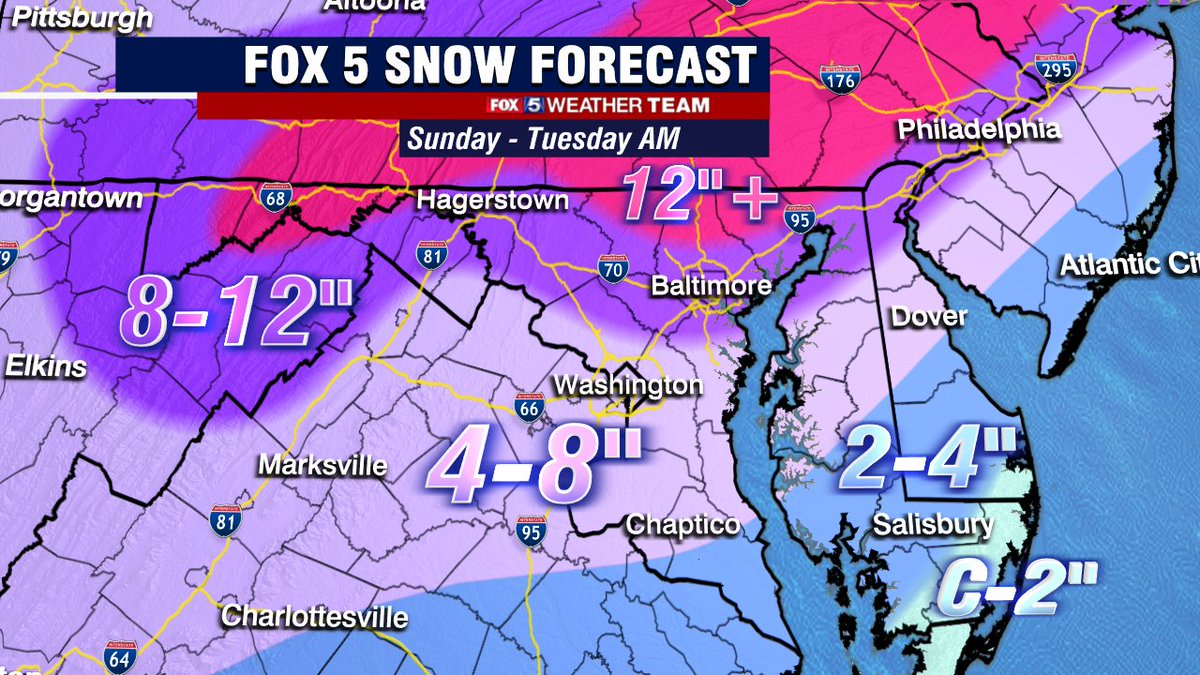
This map shows 8-12 inches for the northeastern side of the county, while it shows 4-8 inches for the southwestern side of the county. Since the 4-8 inches of snow side is so close to the 8-12 inches side, areas there(4-8) will see totals like 7-8 inches, I wouldn't be surprised if they get more than 8 inches.
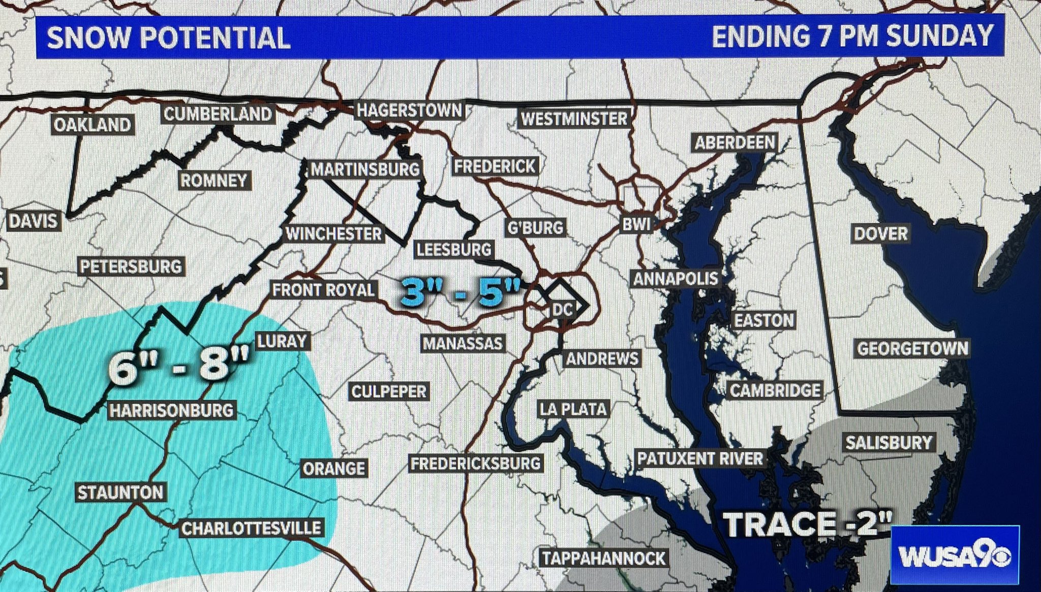
WUSA 9:
Disclaimer: They have 2 maps. I will show both maps and then add up the totals.
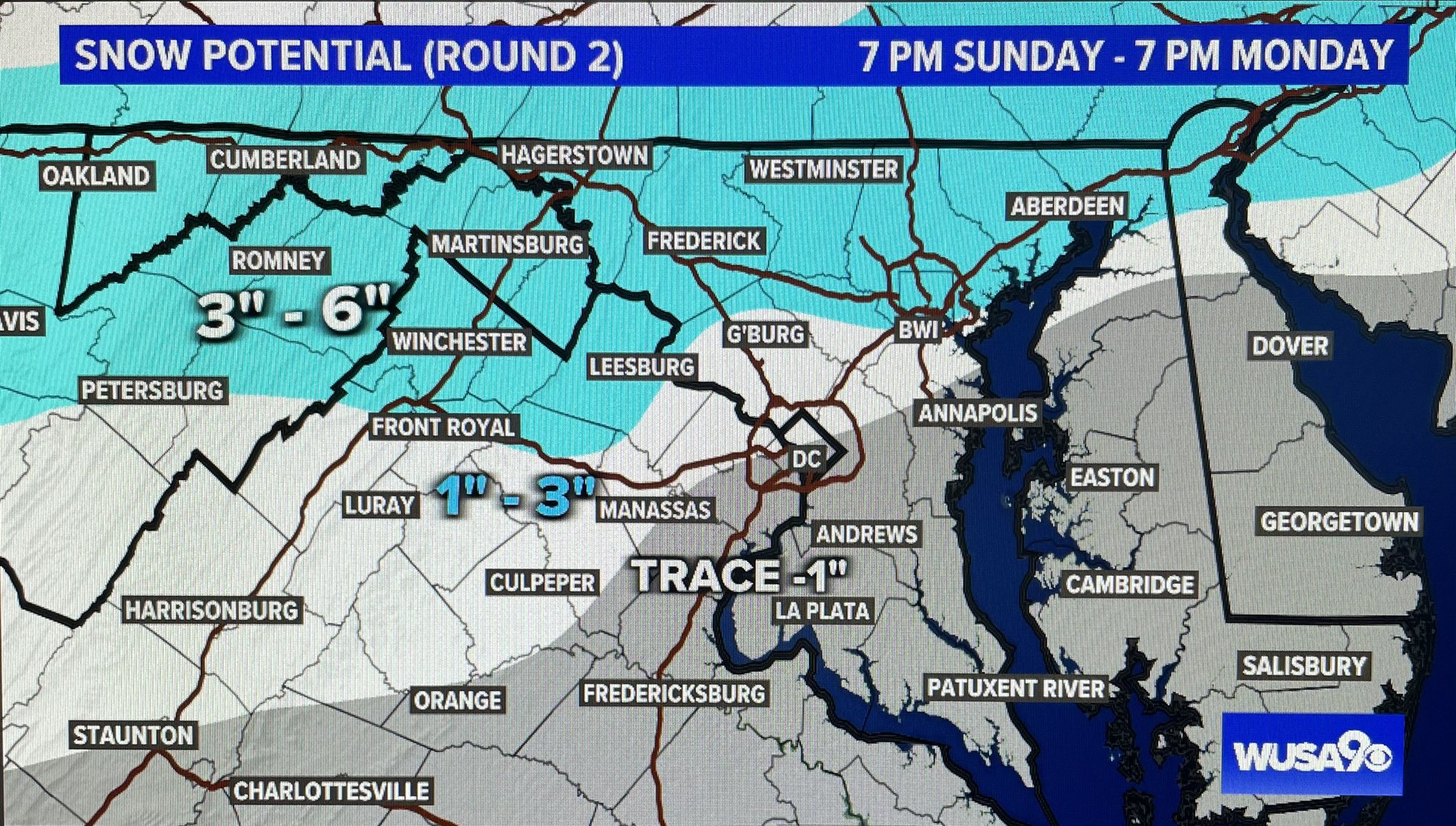
The second round, from Sunday night to Monday, shows 1-3 inches for most of the county, and 3-6 inches for the really upper part of MoCo. Overall, for most of this county, WUSA 9 predicts 4-8 inches, while for the really northern part, 6-11 inches of snow. I feel like some areas in the light blue could see totals at or over a foot of snow though.
NBC 4:

ABC 7:

ABC 7 shows 4-6 inches of snow through early Monday. I assume this is not the storm totals and the forecast only for Monday. I agree with this map, in terms that everyone gets 4-6 inches of snow on Sunday. However, they say that 1-4 inches of snow will fall on Monday, and along with the 4-6 inches, that's 5-10 inches of snow, totally. They say that locally, you can expect 4-8 inches of snow, with higher totals north and west. Overall, I agree with this map.
Capital Weather Gang:
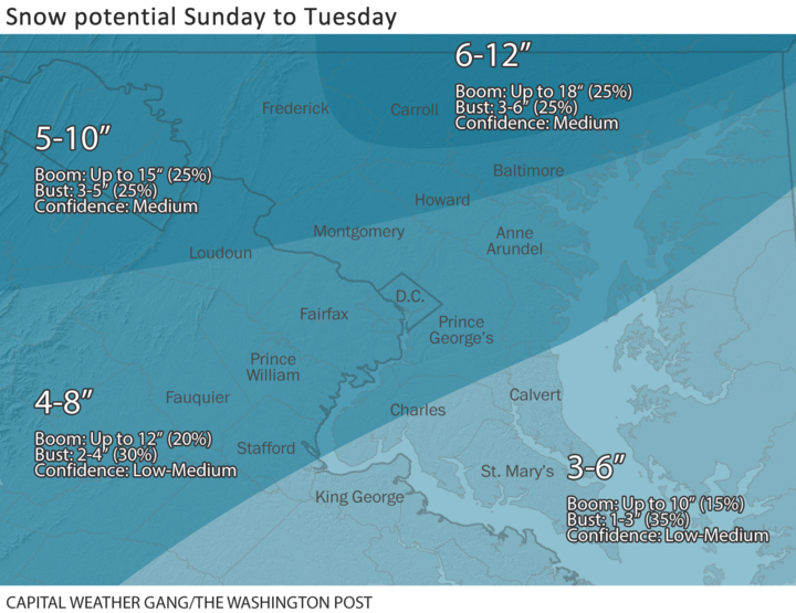
This map shows 5-10 inches for the upper half of the county and 4-8 inches for the lower part of the county. However, the 5-10 inches area went up a little bit north, but nothing significant, at least compared to their last map. In the 5-10 inches area, the boom and bust potential are the same, while in the 4-8 inches area, the bust potential is 10% higher than the boom potential.
National Weather Service:
Expected:

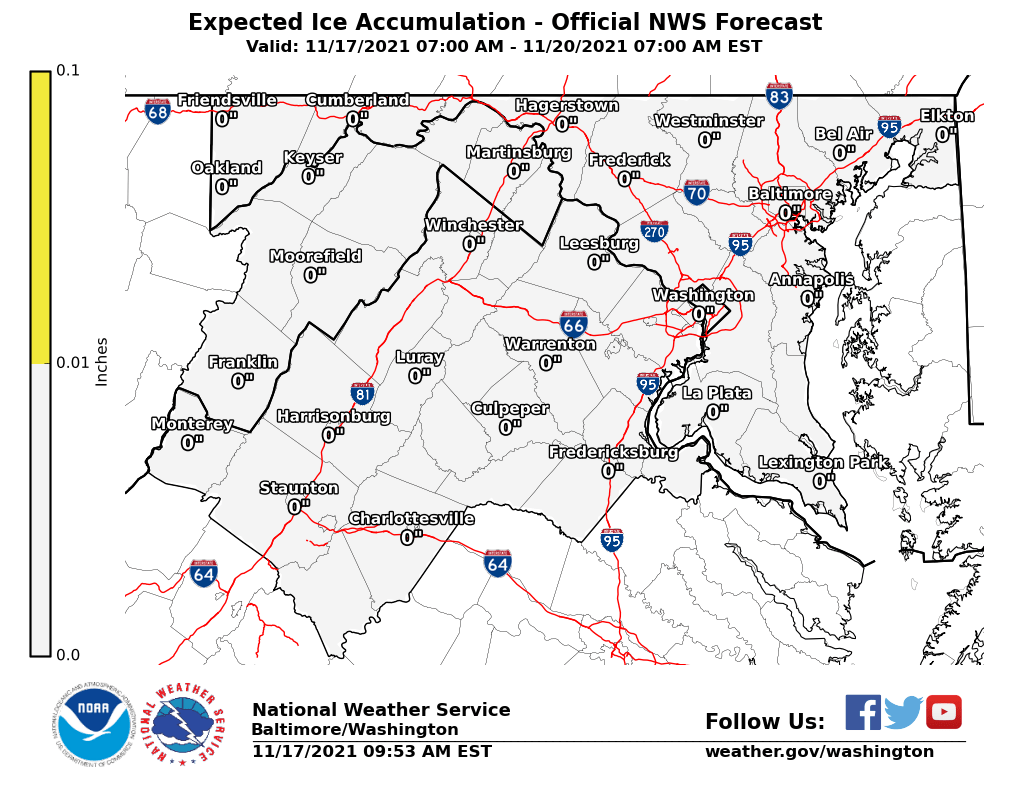 |
| The NWS shows 0.01-0.10 inches of ice for the majority of the county, with the middle of the county getting 0.1-0.25 inches of ice. The ice won't be the main problem, it will be the heavy snow, and I don't think the ice will cause power outages. |
High-End amounts(boom scenario):
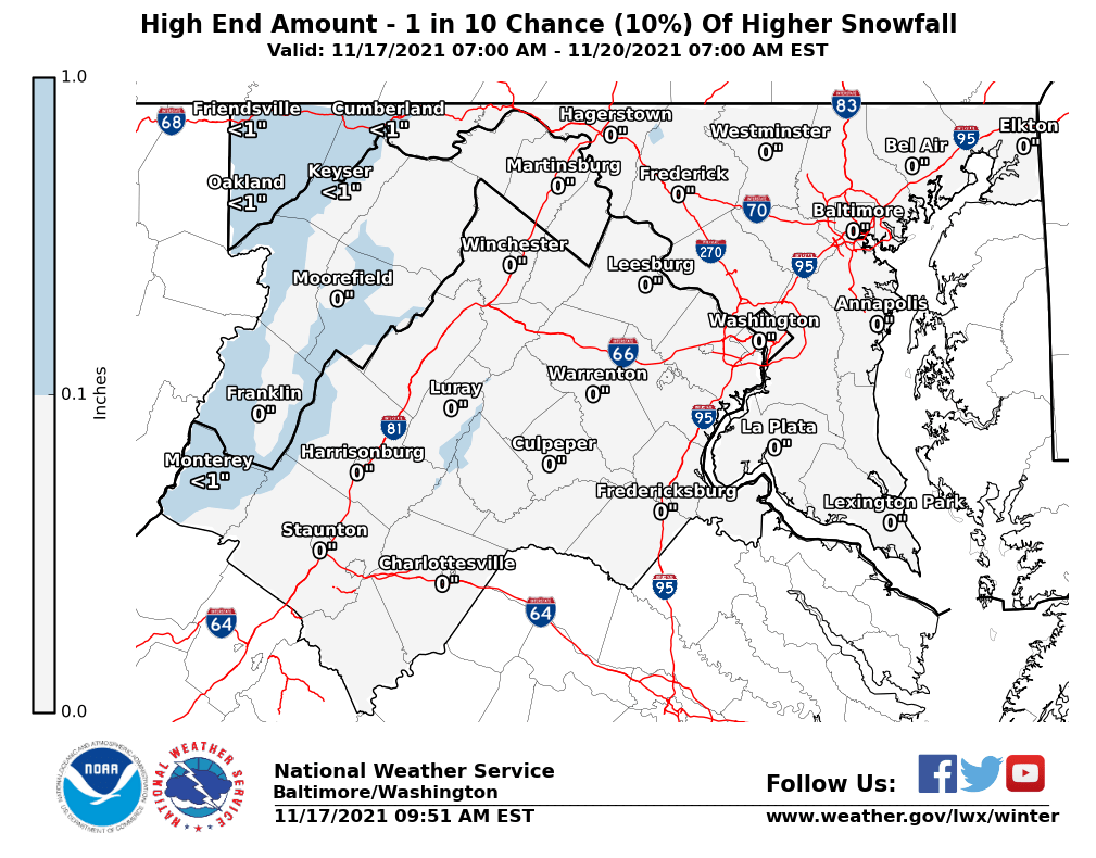
This map shows 12-18 inches of snow for almost the whole county, with a small sliver of southern MoCo in the 8-12 inches range.
Low-End Amounts:
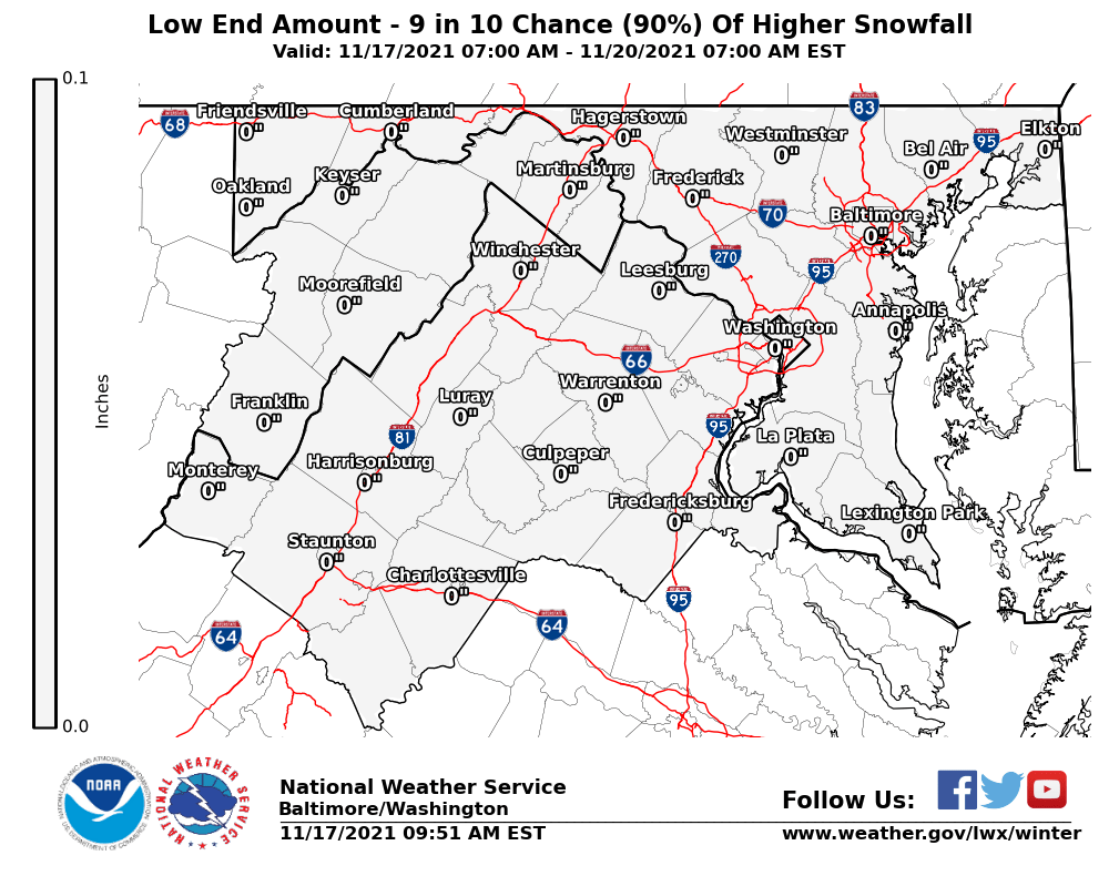
This map shows 4-6 inches for the entire county, in case we get a bust. This still shows a moderate impact event.
So overall, how much do I think we will get? I think for the southern part of MoCo, they will see 4-8 inches, and for the northern part, we could see 6-12 inches(though I think most areas will see 10 or less inches). However, there are 3 scenarios.
Scenario #1(most likely): We see 3-6 inches of snowfall on Sunday, and as we go into the night, the snow will turn into a mix, and then we will see a dry period. Then, as we transition into a coastal low, we turn back to all snow, and it stays that way until the storm tapers out. 3-6 inches of new snowfall in northern MoCo, and 1-4 new inches in Southern MoCo. Totally 6-12 inches for northern MoCo and 4-8 inches in Southern MoCo.
Scenario #2(bust, less likely): We see 3-6 inches of snowfall Sunday, then as we go into the night, we either: have too much warm air and see rain or get dry-slotted(being dry slotted is more likely). The coastal low doesn't transition well enough to get more snow on Monday, and we don't see much more snow accumulation. 4-7 inches throughout the county, but less will be on the ground.
Scenario #3(boom, more likelier than bust but still less likely than expected): We see 3-6 inches fall on Sunday, and then we have more cold air and moisture than what was expected in the night, continuing the snow(no mixing), with a very short period of a lull, and then as we go through Monday, we see many heavy bands of snow, possibly dropping 1-2 inches at a time, and we see snow fall until Tuesday, giving us 6-12 inches more along with the original snow that fell on Sunday. This will bump our storm totals to 10-20+ inches of snow.
SNOWFLAKE PREDICTION:
3.5 SNOWFLAKES(for Monday)

I am going with 3.5 snowflakes for this storm because I think with 4-8 inches of snow, and even more in northern MoCo, any in-school activity/work will be completely shut down. Roads are going to be very slick and icy + snowy, not to mention the long duration of the storm, which will help continue to worsen roads. We also will get some freezing rain, just to make matters even worse. I think offices will close too, we haven't seen this type of snow in a LONG TIME. Although I don't think we will lose power, MCPS said that if offices and schools were closed, virtual learning would be closed too. The reason this is not 4 or 5 snowflakes is that if we bust and our coastal low doesn't deliver, we probably won't see a closure. I am being conservative with my prediction, but I am leaning towards no school. This is not my final prediction, so stay tuned for the next one tomorrow!
In conclusion, there are many things that could go wrong with this storm and we don't see much. However, I feel like we are likelier to see a boom than a bust, even with that being said. I feel like we will see some heavy bands throughout Monday. Snow will RAPIDLY accumulate on any untreated surfaces, due to the cold air that has been in the region for the past couple of days, and temps will be below freezing when it starts to fall. Any in-person thing will probably be canceled and will be switched to virtual(if it can). This will be a long-duration storm, so the impact will be felt through Sunday to at least Tuesday. We will see enough snow to sled, and build a snowman. This is a pretty significant storm. However, I don't think we will see power outages, because we aren't seeing wet, heavy snow. Please avoid any non-essential travel, and if you do, make sure to be very careful and drive slowly. Make sure to also keep an emergency kit that includes jumper cables, a snow shovel, something to wipe off snow, a blanket, a first aid kit, sand or cat litter, a radio, sufficient food, a water container, extra batteries, paper towels, and extra clothing. Check out more for what you should do here: NWS Winter Safety Kit. Overall, this storm is not just a couple of inches with minor impacts, this is an impactful, dangerous storm that you should take seriously. Stay safe, and I hope you enjoy the snow!


