Thursday, February 11, 2021

Saturday Storm Update and Some Other Storm News

 Well, snow lovers love a good snowstorm. Others hate it. But, the type of storm coming up on Saturday is something both snow lovers and snow haters hate: an ice storm. Sure, a little bit of freezing rain that causes a glaze on surfaces is pretty, and not much is done. But once you get over a quarter inch, that's where instead of looking pretty, it becomes devastating and catastrophic, with injuries and even sometimes fatalities occurring. We have 3 storm threats in the next week or so. The first one is on Saturday. The second one is on Monday to Tuesday(may linger onto Wednesday) and the third one is on Friday to Saturday. Thankfully(I say that because it's ice, not snow), this storm does seems to have less moisture than the next 2 ones. However, as it stands, the next two ones look like ice storms too. And just to show you how active this pattern is, let me show you something.


Well, there's something you don't see everyday! Winter storm threats for the northern regions for the entire time period the NWS' "Winter Storm Threat" covers! I have literally never seen this before. This is insane! There is an enhanced threat for the entire region I forecast for, on Saturday(high confidence, "low" impact). A lot can change though. Besides the crazy pattern that can easily be compared to the historical, record-breaking(in terms of snowfall) winter of 2009-2010, let's focus on our first threat: Saturday. Watches have been issued JUST south of us for Saturday's threat. I assume they will be extended northwest soon enough. You know it's a little bit wacky when D.C is the most northern zone in a watch; or any alert for that matter!

European Model:


The European model shows moderate-heavy freezing rain falling the whole time this storm, with rain far south of our county and snow far north of the county. It doesn't show any sleet either. It shows the system starting on Saturday evening/night and shows it getting out of here by Sunday.


Now, the European model has been very bullish with the ice, showing over a HALF inch for the entire county(image courtesy of Justin Weather) Once there is over a half-inch of ice, widespread power outages occur, and severe tree and power line damage is done. Not to mention travel is literally impossible. Although this is a lot, even half of this would cause major issues. The European does not seem to be backing off. Temps will be much below freezing on the ground the entire time, so any ice should accumulate.

GFS:

The GFS mainly shows scattered freezing rain showers instead of an ice storm. It shows them lasting from late Saturday night and shows them stopping after very early Monday morning(1-3 AM Monday).


The GFS shows much less ice than the European model, with only 0.05 to 0.15 inches of ice(Phew!). This will still cause disruptions though.

CMC:


The CMC shows the storm starting as an icy mix(sleet and freezing rain) before turning over to heavy freezing rain and then eventually going off to the ocean. More sleet would lessen the impacts of this storm, as sleet is less disruptive than freezing rain.

The CMC shows 0.3 inches - 0.5 inches of total accumulated precipitation. If most of this is ice, we could have a pretty disruptive problem on our hands.


Temps on the ground will be below freezing the entire time. Plus with the snowpack we have right now, ice will accumulate on any untreated surface, and will wash away pre-treatments if not put out regularly. This freezing rain shouldn't melt completely once the storm is done, it should be staying here for a while.  I won't be showing the other storms until this storm is done. Why? This storm will set up the next storm from Tuesday to Wednesday. And the Tuesday to Wednesday storm WILL set up the next Friday - Saturday storm. And besides, we are very far out. I don't think it's a good time to talk about them, because they will be changing rapidly. They could be major winter storms for us(the storms next week). They should be either snow or ice due to an arctic high and cold air in place. The latest storm(this Saturday) does seem to be trending towards being weaker, which is good. After the next 2 weeks, winter does seem to be weakening its grip a bit(we could still see some good snow after the next 2 weeks). Travel will be very dicey and difficult; impossible at times on Saturday evening - Sunday. Please avoid any unneeded travel unless absolutely necessary, and make sure to stay slow and careful on the roads; don't make any sudden movements or breaking. What appears to be wet surfaces is most likely ice. I will release another call tomorrow and my final call on Saturday.


Wednesday, February 10, 2021

Nowcast For Wednesday - Friday Storm

Go check out my forecast first before reading this nowcast: https://mcpsweather.blogspot.com/2021/02/final-forecast-for-wednesday-friday.html

Thursday:

11:40 AM Update: 

The snow from the first wave is gone now as we wait for our second wave. It won't really drop that much snow though, a coating to 2 inches if we do see some measurable accumulation. Now we focus on our next threat, the one on Saturday. As soon as models come in, I will start making a post.

9:45 AM Update:

I have gotten many reports in the county of people getting winter storm warning levels of snow. 4 inches in Clarksburg, 6 inches in Damascus, 2 inches in northern Germantown. Honestly, even for northern areas in our county, you can see such a difference, ranging from 2 all the way up to 6 inches. It just depends on who had the most precipitation and cold air. I was surprised how much less Clarksburg got than Damascus; that's a 2-inch difference! That's not the much of a mile difference too. It just shows how much of a difference in amounts two places can have when they are a short distance away. I wouldn't be surprised if someone pushed over 7-8 inches, but most of the snow accumulation is done. A coating to two more inches of snow will fall in the second wave, but I expect totals to be on the lower end of this scale.

8:38 AM Update:

I measured 2 inches of snow on the ground in Gaithersburg. Snow is still falling at a moderate rate. One thing that I did not really take into account was the amount of mixing that happened last night. I knew some mixing would happen, but not to the extent it was. I still think that another 1-2 inches of snow may fall when this storm is said and done, but I am not so sure anymore. Mt. Airy(technically in Carroll and Frederick counties but still very very close to MoCo) has reported 5 inches of snow and is still counting. It does have higher elevation though, but I think some areas in our could(not probably) reach 4-6 inches. It's a possibility. We will see how it plays out. I do guarantee at least a coating of snow to fall everywhere. We will start to see precipitation dry out as we go through the morning. Then, in the night, some snow will fall again. Temps will be much colder than what we had yesterday, but there will be less moisture. Dendritic flakes will help us get some more snow through Friday. Overall, my forecast seems to be holding up ok, but we will see. I will shortly be working on a post not for this storm, but for the storm on Saturday-Sunday.

Wednesday:


10:45 PM Update:
This is where the snow/sleet line is right now. Only more interior upper MoCo is seeing snow. The rest of the county is seeing sleet or a snow/sleet mix. In Gaithersburg, a snow and sleet mix is occurring. There may be some localized areas in the sleet area that may be seeing snow, but even there sleet will probably mix in at one point. Precip types will go back and forth.

10 PM Update:

Heavy snow should be continuing into the night and into Thursday. It should start to taper off late Thursday morning/afternoon before our second wave. Precip types will probably switch back and forth, but the snow should win out overall(southern MoCo will probably see some mixing, but they will see some good snow too). This wave will drop most of the snow accumulation though. The second wave will drop a little bit more and might drop an inch or two. Temps should be below or at freezing. Roads and sidewalks completely covered; everything covered in snow. Wet areas turning into ice. Right now, it's looking a bit better than expected, at least for snow lovers.

9:10 PM Update:

The heavy snow has reached us, and I can definitely confirm it coming down here in Gaithersburg. It is falling at a very heavy rate, causing low visibility, and is now sticking to sidewalks/roads. Temps are at or below 32, so now snow should accumulate easier. This snow will last throughout the night and will start to clear up on Thursday late morning/afternoon. 

8:20 PM Update:


This tweet from Tom Tasselmyer shows an image from what I assume to be the SPC(Storm Prediction Center). It says that snow intensity will pick up in the area in Tennessee, West Virginia, and Kentucky, as "strong jet-induced upward vertical velocities" move in. So what does mean for us? That area of heavy precipitation(snow for us) will be heading RIGHT our way. This will help us get more snow accumulation. After what everyone made out as a hopeless, terrible storm this afternoon, there may be some hope.

7:45 PM Update:

The snow seems to have tapered off into light snow, cause I don't see anything falling. The snow still seems to be slowly accumulating but I don't really know. Even if nothing is falling, that is ok. The main course of the precipitation and the one that will bring us the main accumulation from this storm is far west of us, and it's coming east. Should be here in the next 2-4 hours.

7:12 PM Update:

We have officially reached 32 degrees here in Gaithersburg. Lots of surfaces that aren't snow-covered are wet, and along with the heavy snow still falling, there will be black ice underneath the snow. Snow should accumulate rapidly now.

6:40 PM Update:
The snow is falling at a very heavy rate here in Gaithersburg. I can't see much; it looks like there is a lot of fog. All surfaces(excluding sidewalks and roads) are covered in snow. I assume roads and sidewalks will get covered once temps drop below 32 in the night. This isn't even the main precipitation course, we will be seeing heavier, consistent snow during the night today, and midnight to morning hours tomorrow, before it starts to taper off. With the updated NWS map, I am now going to change my snowflake prediction to a 55% chance of school buildings being close. Conditions are colder than expected, and at these rates, snow will stick on untreated surfaces rapidly.

6:20 PM Update:
The NWS has updated their snowfall map for MoCo, and boy does it look a lot better for snow lovers. 4-6 inches for the eastern half of the county(and northern) and 3-4 inches for the rest(southern half). The main reason they upped their map by a lot(at least from what I think) is because of the first band dropping a coating, which meant that the snow had to fall at a heavy rate, especially with temps above freezing. That cooled the atmosphere and ground enough everywhere to where there will be more snow accumulation, and there will also be more moisture(not so sure about this one). Right now in GBurg, it's coming down really well here. Almost 32 degrees.

6:00 PM Update:

Snow still coming down at a pretty heavy rate. The temperature has dropped by 6 degrees and I assume it will drop to at or below freezing in the next hour or so. Warnings have been set up for counties right north of us(Cecil, Upper Baltimore County, Harford). I wouldn't be surprised if the warning gets extended a bit south, to upper MoCo. It could happen if precipitation is heavy enough, and could even drop to southern MoCo. Already a decent coating on the ground.

5:30 PM Update:

The heavy snow is causing major dynamic cooling in the atmosphere, meaning that temperatures are quickly dropping. The temperature has already dropped 4 degrees in just an hour. And as the sun starts to set, temperatures will drop even more as there will be no sun angle to worry about. Snow starting to accumulate on surfaces. 

5:12 PM Update:

The snow rate is picking up fast. It's really coming down here. Big, wet flakes falling at a heavy rate means that snow will be accumulating on any untreated surface soon, especially when we drop below freezing. Areas that usually pick up the snow accumulation first and fastest were wet for a while, and now becoming snow-covered as the ground cools. If it keeps falling at this rate, I wouldn't be surprised if roads and sidewalks get fully covered.

5:00 PM Update:

I can confirm that light snow is falling and reaching the ground here in Gaithersburg, and many other people have reported snow falling in MoCo too. It's not sticking and probably won't stick until we get into the night. There are warnings for Frederick and Caroll counties due to afternoon models being aggressive with snow there. Still an advisory in MoCo.

4:20 PM Update:

The snow that was reported across the region(mainly west of us) was just the pre-teaser; not actually part of the storm. The main snow is still far west of us and is coming our way in the next 1-3 hours.

3:30 PM Update: 

Snow has been reported in our western neighboring counties(Loudoun, Fairfax). If we are snowing at 36-42 degrees, it may be a good sign that we can support all ❆ throughout the night.

Final Forecast For Wednesday-Friday Storm and Snowflake Prediction

UPDATE: Snow has been reported in our western neighboring counties(Loudoun, Fairfax). If we are snowing at 36-42 degrees, it may be a good sign that we can support all ❆ throughout the night. More information on my nowcast post: https://mcpsweather.blogspot.com/2021/02/nowcast-for-wednesday-friday-storm.html

Unfortunately, something has occurred that if you live in the DMV, you would have seen before: Storm Disappointment. The northern trend did happen, but only for the first wave/part of the storm. We are the bullseye for the first part(the DC area). However, the second part mainly seems to just miss us to the south. That's why we are under winter weather advisories instead of warnings(in effect until 10 AM Thursday). We will see some snow in the second wave (Thursday afternoon/evening - Friday), but as of now, it's looking very limited, decreasing our overall snow totals. And now we have to throw some mixing and rain into it as well. Northern MoCo has the best chance of seeing more accumulation than southern MoCo due to colder air and less rain/mixing, but they will see less snow from the second wave.


GFS:


The GFS shows all snow for the entire county the whole time. The first wave drops some moderate snow and shows it ending around 10 AM Thursday. By now there are 1-5 inches on the ground, with the most snow in extreme upper MoCo and the least snow in Southern MoCo. Then, in the second wave, it shows some light-moderate snow hitting us, dropping an additional 1-3 inches of snow(less snow in Upper MoCo and more in Southern MoCo). When this storm is done, it drops 2-6 inches of snow.

NAM(12km):

The latest NAM does not appeal to snow lovers. It shows the storm starting out as snow, however, it shows lots of mixing and rain for the whole county during the first wave, before turning back to all snow. The second wave doesn't hit us that well at all. It shows 2-6 inches of snow, with the most in Damascus(NE areas) and the least in SW areas.

Note: I used Pivotal Weather because of the Kuchera ratio; tropicaltidbits.com doesn't have that.


HRRR:

The HRRR shows all snow for MoCo during the first and second waves.  The first wave drops 1-3 inches, with more snow in the NE areas than SW areas. The second wave, at least compared to the other models, hits us the most, dropping an additional 1-3 inches. Overall, 2-6 inches, with the most snow in NE regions and the least snow in SW regions. However, there is one thing that Tony Pann said that I want to put in. "This is the 12z run of the HRRR. See that red "L" on the map? That's a surface Low. The fact that this piece of energy has a surface reflection, tells me this snow event could have a little more gusto for the Baltimore Metro! All that to say: Snow totals could be higher."


European:


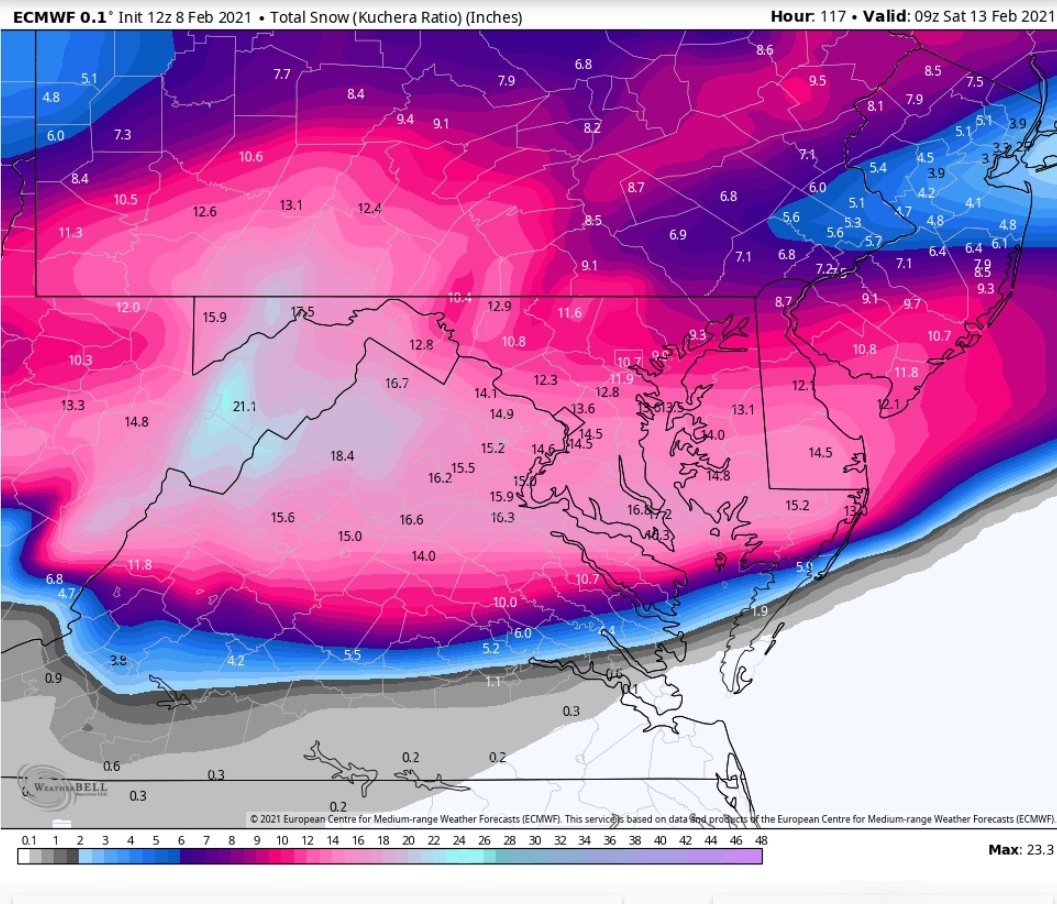
 The Euro shows the storm starting as snow(a little bit of mixing though) and then staying moderate-heavy snow until the first wave is over. The second wave remains south of us, and the Euro shows no snow at all from the second wave. Overall, the European shows 3-6 inches, with the most snow in the eastern regions(NE specifically) and the least snow in the SW regions. This is assuming a 10:1 ratio though, the ratio will be a little bit higher or lower. 


Maps:

Fox 5:


Fox 5 shows 2-4 inches for the entire county, at least for the first wave. They then show a coating to 2 inches of snow for most of the county, with the eastern section having no snow accumulation. This adds up to 2.2-6 inches of snow. Mike Thomas said that he was hesitant to bring that 4-6 inches of snow area south.

WUSA 9:

WUSA 9 shows 1-3 inches of snow for the whole county. They also said Gaithersburg, Leesburg, Frederick, and areas north of that will probably see totals on the higher end of this range(2-3 inches).

ABC 7:


ABC 7 predicts 2-5 inches of snow, with a bust being less than 2 inches and a boom being over 5 inches. They didn't give a map.

NBC 4:

From this screenshot, they think that there will be 3-6 inches of snow. The rain-snow line will be "in play" during this storm, and could affect road conditions and snow totals.


NWS:

The NWS shows 3-4 inches for most of the county, with a small portion in upper MoCo in the 2-3 inches range(don't know why). They expect the precipitation to come at 5-7 PM. 
The high-end totals are 4-6 inches, with Damascus in the 6-8 inches range.

The low-end totals are 1-2 inches of snow.

Capital Weather Gang:


They predict 1-3 inches for the first wave for most of the county, with extreme upper MoCo in the 2-4 inches range, and southern MoCo in the C-2 inches of snow range. Accumulation there will be mostly on  grass, and sleet and rain will mix in at times.
For the second wave, they think that a coating is possible for most of MoCo, and a C-2 inches for southern and western MoCo.


Snowflake Prediction:

2 Snowflakes(30% chance of offices closing {no virtual instruction} and a 50% chance of school buildings closing): ❆❆

I don't think we will have no school because offices didn't close for the storm last time and that was forecasted to have significantly more snow. I will keep you updated on the latest information in my nowcast post. 

So what do I think? Well personally, I am going for 2-6 inches of snow, 2-4 for Southern MoCo, and 3-6 for Northern MoCo. Although everyone is treating this storm like this is a complete failure, the models are showing at least 2-3 inches of snow for our region. Temps will be hovering at freezing though, and a little bit above freezing in the afternoon hours, but most of the snow should fall in the night, where temperatures should be below freezing, and there is no sun angle to hinder accumulation. The first wave I am confident should drop 1-4 inches of snow. The second wave may drop an inch or two but I have less confidence in that. I think we will see at least 2-4 inches(bottom line 1-3 inches). On my snowstorm rating system(I will be working on that more), this would be rated a moderate snowstorm, at least for northern MoCo.  Precipitation will arrive at 5-7 PM(may start out as a mix) and will continue on throughout the night, into Thursday morning, where precipitation will taper off as we wait for our second wave and enter into a lull. The second wave will start to enter on Thursday evening. It will have lighter snow accumulation and will start to clear out by Friday morning. Scattered snow showers are possible on Friday afternoon. And we have many more wintry threats coming up in the next couple of days, the next one on Saturday-Sunday, and another one on Tuesday. I would be surprised if we don't see any more snow from this pattern. Stay tuned!


Tuesday, February 9, 2021

Second Wednesday-Friday Storm Update and First Snowflake Prediction

 This storm is a very difficult one to predict, however, I have good news for snow lovers: This should be an all snow event, regardless of amounts. However, this is a long duration storm. And the last long-duration storm, models were very jumpy and had so much disagreement, even 1-2 days out. Watches haven't been in effect yet for us and the general DMV(excluding western MD). Even with that being said, we are at a point where everyone should prepare for an impact on their day. But just how much snow are we looking at? We will try to answer that question using models.

Models: 

GFS:


The GFS shows an all snow event(mixing in western MoCo is a bug because upper air temps below freezing). It shows 2 waves, however. The first wave drops a good 2-4 inches, with less snow in the southern suburbs and more snow in the northern areas. Then, there is a dry period of no snow. Then, we start snowing again, and we into the second wave. This wave drops another 4-6 inches of additional snow onto the snow that already fell. It shows a good 6-9 inches of snow when this storm is said done.

The American model is more northern based than the other models, as you will see shortly. It shows more snow in our NW areas and less in our SE areas. However, in the first wave, dry slotting and not having enough moisture is a problem cause that could easily happen; models don't pick up on it too much. Cold air isn't an issue here though. And the second wave has much more energy and potential than the first one.

European:

The European became less bullish with its storm. Like the GFS, it shows 2 waves, they both start and end at around the same time, and there is a dry period before the next wave. However, the European has shifted south. Again. I will show you the snow map, however, I have some good news along with that.
The European model(sad violin please) shows ONLY 3-5 inches of snow(totally), with less snow in the NE part and more snow in the SW part. However, this is a 10:1 ratio, and the ratio will likely be bigger than this, meaning more snow. Sticking shouldn't be a problem; as most of it should fall in the night. I have some bigger news though. Before the last long-duration storm(Jan 31 - Feb 3), the European model was trending south, and in the last minute, it trended north, giving parts of PA over 30 inches of snow. 
Now, we won't be seeing that much snow, but the bullseye should go NW, giving the DC area the most snow out of this storm. It's called last-minute for a reason. :D


NAM(12km):

The NAM shows an all snow event. The moderate-heavy snow lingers for a while before quickly moving to the south. The second wave seems to miss us as well. I don't think we won't see the second wave miss us, because again; the northern trend. I have never seen it not happen with these kinds of storms. Remember Jan 31 - Feb 3, and how the models shifted to give PA/NJ the bullseye of that storm, some areas getting over 30 inches. 😀

CMC(GEM):

The GEM shows the storm starting as rain(I doubt it will happen, we have a sufficient supply of cold air). It shows the first wave dropping a couple of snow, which is moving SE, then another wave coming from the west hitting us, moving NE, and going off to the coast. 

It shows a good 6-10 inches for MoCo, with more snow in the SW areas than the northern areas. But again... that north trend. I wouldn't be surprised if it shows Northern MoCo getting more than Southern MoCo. If that bullseye moved a bit north, our county would be right in the jackpot. And this is a 10:1 ratio, numbers will likely be higher than this due to the atmosphere being colder.

Maps:

National Weather Service:

Expected:

The NWS is counting in the NW trend, and I think that is what people should do for this storm because it always happens. It shows 6-8 inches for all of MoCo. I like how they are playing with this storm.

High End:

The NWS shows 8-12 inches of snow for the whole county if this storm were to boom.

Low End:

The NWS shows 2-3 inches for most of the county, with 3-4 inches for super NW MoCo. This would happen if this storm busted. 

The National Weather Service shows a moderate threat of a winter storm for the entire region from Thursday-Friday. This hasn't occurred since 2019.


Fox 5:

Fox 5 shows a good 3-6 inches for our county. Mike Thomas said that they are on the low end of totals compared to guidance due to many unanswered questions. I understand why, but that northern trend should at least put us in the 4-8 inch range.
 
WUSA 9:

Note: this is only until Thursday evening, additional snow will fall on Thursday Night - Friday. They show 3-5 inches for upper MoCo and 1-3 inches for the rest. I think they are going a little conservative with the snow totals, but that is fair.

Capital Weather Gang: 
They show 3-7 inches for Western MoCo and 2-6 inches for the rest. I agree with this map more than the other ones, cause it does give the potential for over 6 inches. 

NBC 4 thinks 1-3 inches for the first wave and 1-3 inches for the second wave. Storm totals across the county add up to 2-6 inches of snow. Again, it's good to play conservatively for your first call as more data comes in. ABC 7 also thinks 3-6 inches of snow. 


So what do I think? For my first forecast, I think that we MoCo will see 4-8 inches from this storm. We won't probably see any kind of mixing, and we should have sufficient cold air in place; meaning that the snow to liquid equivalent ratio will be above 10:1 like it normally is(good for snow lovers). Surface temps should be cold enough to support accumulation and to help us, snow lovers, even more, most of the snow should fall during the night, where there won't be a sun angle to hinder accumulation. This will be a high impact storm, and you should take it seriously. The second wave of snow will probably bring more snow along with it, as it is more powerful. The NWS has a moderate threat for the entire region(not just the northern or southern part, hasn't happened in around 2 years or so). This might be the biggest snow of the season for Southern Maryland, and maybe even since 2016. 

Snowflake Prediction: 

For a snowflake prediction, there is still so much we don't know about, but for now, I stand at 3 snowflakes. School buildings will probably close on Thursday, but offices may not, because there will be a lull between the transition to the second wave, and I think that Montgomery County will try to do a delay or something so that they can go to work at the lull. There is still so much that we don't know yet, and we have to see live conditions to make a proper prediction. I will make a final call tomorrow with a stronger snowflake prediction. I will also be doing a nowcast for this storm, while its raging on, so you can get live conditions and updates.


Monday, February 8, 2021

Wednesday to Friday Storm Update

We have gotten to the point in storm tracking, where instead of something might happen, something is probably going to happen. This event will be a long-duration event(probably not as long as the Jan 31-Feb 3 event though), lasting over 24 hours. This storm has a lot of potential to bring good snow to us, and possibly even increase our seasonal snow totals to become above-average(for a La Nina, that's pretty good)! However, we still have a lot that we don't know about. We don't know the exact amount that will fall, who sees what, things that we often don't know from this point out when we are looking at winter storms. The first part of this storm has gotten into the range of short-range models, but even with that being said, global models are our best bet at this very moment.


GFS:


As you can see, the GFS remains mostly all snow for us, with some mixing at times. There are 2 waves, Wednesday-Thursday, and then another wave on Thursday-Friday. It does show a dry period between the wave transitions. Temperatures will stay below freezing(on the ground) this entire time. 


The GFS shows a widespread 7-14 inches, with more snow in the NE parts than the SW part, when this storm is all said and done. It has been caving towards the snowier, colder European model.

European:
The European Model shows non-stop heavy snow, without any break. This model is our best bet at the moment, and it is going bullish for this storm.

(Image from Weatherbell, someone who had access to it showed it to me). I wasn't kidding when I said the European model was going bullish with this storm. It shows 10 to 16 inches of snow! And it shifted this storm south as well. With the last minute NW trend(hopefully), this would make the DMV, and MoCo the bulleye of this storm! All of the ensembles show snow for us too, which is a good sign.


CMC(GEM):

The CMC shows the first part hitting us hard with heavy snow, but then shows the second part of the storm going to the south and missing us. However, due to the last minute NW trend, that part of the storm should go right up to us, making us the bullseye. It still shows some significant snow, even with the second part missing us, as you will see below.

The CMC shows 6-9 inches just from that first part, which is pretty good. As I said, I think the bullseye will shift NW, right to us.

The NWS has released their first call snow map. Note that they usually go conservative with totals at first.


The NWS says 4-6 inches for most of the county, and 3-4 inches for a part of Southern MoCo(most of it in 4-6 inches of range). And this only includes totals from Wednesday to Thursday(7 PM). We still have so more snow to go from Thursday night to Friday afternoon. The next part will probably drop at least 1-2 inches more. And I know that is what they are thinking because of the winter storm threats they have issued.


This is their storm threat for the first day(Wednesday-Thursday). They shows a medium confidence, low impact threat for both Southern and Northern MoCo, and a high confidence, low impact threat for the Alleghany Front. Snow is supposed to move in during the afternoon-evening hours, so the threat is understandably low. However, as you will see below, they think that there will be more of a threat on Thursday-Friday.

From Thursday to Friday, the NWS shows a medium impact, medium confidence winter storm threat for the entire region! The models show the bulk of the snow accumulation to be here. Temps won't rise above freezing the whole time.


My biggest concern is that the storm won't shift northwest, and will instead go to the south, giving us ample moisture. I don't think it will shift too north to the point where we don't get that much snow, that's much more unlikely than the storm staying south. The blocking in Canada will create a ULL to cross our region, ergo giving us a long-duration storm. This storm is mainly looking all snow, however sleet and ice are defintely on the table. I expect watches and warnings to be issued soon as we get closer to the storm. Right now, I would consider canceling any unesscary plans from Wednesday-Friday. Offices could close, but I won't make a prediction until tomorrow, cause I need more information. Snow will move in during the afternoon-evening hours of Wednesday, and will start to taper off Friday afternoon. These heavy bands will give us some good snow. As it is looking now, at least 3 inches is a good bet. I will make another post tomorrow and give more details.


Freezing Rain Possible Tomorrow

There is a chance for some spotty freezing rain tomorrow morning. If we were to see some, the most we would have is a glaze of ice. There is a special weather statement for the entire county, including our neighboring counties. This won't have too much of an impact, however with the colder temps recently, this ice can make roads and untreated surfaces slick. If you have to run any errands or do something tomorrow morning, take caution and do them. This won't and shouldn't disrupt any plans. However, we are watching a bigger threat on Wednesday-Friday that if materialized could cause disruptions. A new post will be coming shortly.


From the NWS:

"Special Weather Statement
National Weather Service Baltimore MD/Washington DC
1127 AM EST Mon Feb 8 2021

DCZ001-MDZ013-014-016-503>506-VAZ052>057-501-502-505-506-090000-
District of Columbia-Prince Georges-Anne Arundel-Charles-
Northwest Montgomery-Central and Southeast Montgomery-
Northwest Howard-Central and Southeast Howard-
Prince William/Manassas/Manassas Park-Fairfax-
Arlington/Falls Church/Alexandria-Stafford-Spotsylvania-
King George-Northern Fauquier-Southern Fauquier-Western Loudoun-
Eastern Loudoun-
Including the cities of Washington, Bowie, Suitland-Silver Hill,
Clinton, College Park, Greenbelt, Laurel, Camp Springs,
Glen Burnie, Annapolis, Severn, South Gate, Severna Park, Arnold,
Odenton, St. Charles, Waldorf, Germantown, Damascus, Bethesda,
Rockville, Gaithersburg, Silver Spring, Lisbon, Columbia,
Ellicott City, Dale City, Manassas, Woodbridge, Lake Ridge,
Montclair, Reston, Herndon, Annandale, Centreville, Chantilly,
McLean, Franconia, Arlington, Alexandria, Falls Church, Falmouth,
Fredericksburg, Dahlgren, Warrenton, Turnbull, Purcellville,
Leesburg, Ashburn, and Sterling
1127 AM EST Mon Feb 8 2021

...POTENTIAL WINTER COMMUTING HAZARD FOR THE WASHINGTON AND
FREDERICKSBURG METROPOLITAN AREAS TUESDAY MORNING...

There is a potential for hazardous commuting conditions for the
Tuesday morning commute. A period of light freezing rain is
POSSIBLE (a 30 percent chance) Tuesday morning across the
Washington and Fredericksburg Metropolitan areas. A light glaze of
ice is possible on area roads.

If this threat does materialize during the Tuesday morning rush-
hour, many roads could quickly turn icy. This could lead to
dangerous traveling conditions, multiple accidents, and extensive
delays.

If commuting Tuesday morning, be aware of the POSSIBILITY of
significant travel disruptions. Plan ahead by allowing for extra
travel time, and consider using telework options.

Stay tuned for updates on this potential winter weather episode."

Sunday, February 7, 2021

Sunday Storm Recap and Many Storm Chances


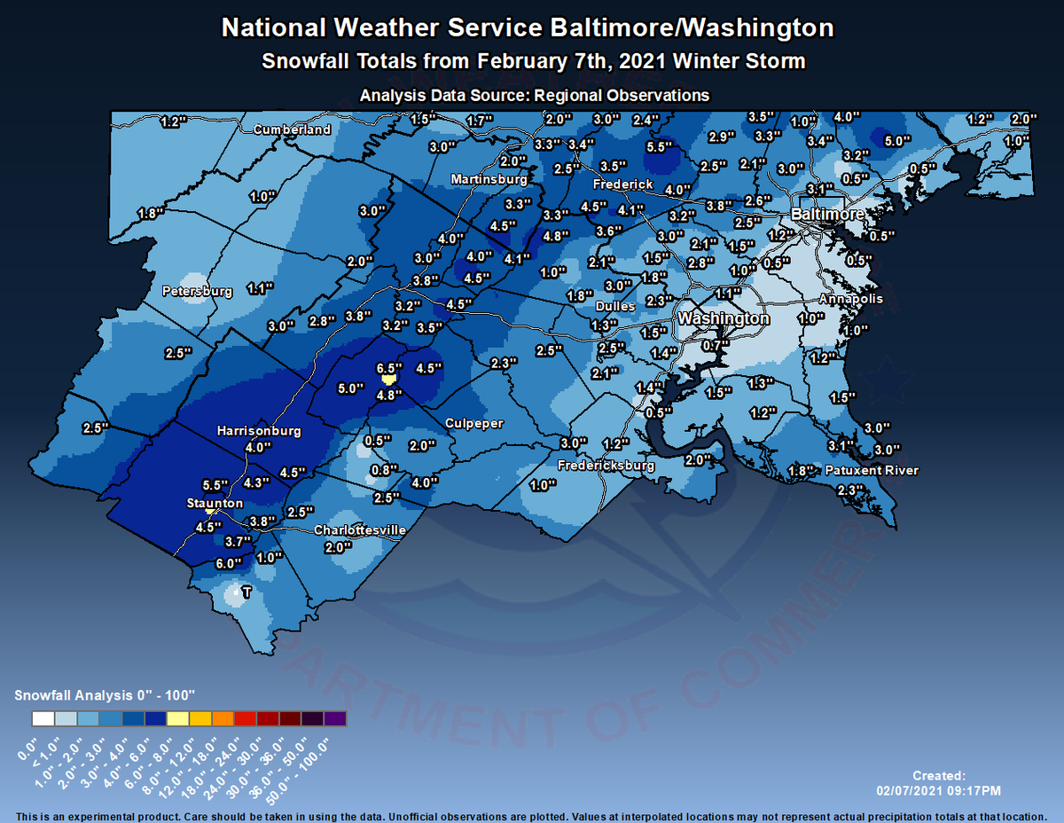
So overall, this storm wasn't too bad, even though the snow totals up there look bad. According to this map, around 1-3 inches of snow fell, but in localized areas, from what I have heard, around 2-5 inches of snow fell. I myself measured 4.2 inches of snow, which includes compacting and melting, bringing up my winter total(so far) to 17.2 inches of snow. It started out as rain and turned into wet, heavy flakes. Snow won over the marginal temps and accumulated on any untreated surfaces, but quickly melted as precipitation became lighter/stopped. This storm ended as mixed rain and snow, at least for me. Now, as temps quickly drop, any wet surface will become ice rapidly. A flash freeze is likely. My forecast was a little bit less than expected, but it still verified! 

But now, I want to talk about the storm chances we have coming up. We have a slight threat for Wednesday-Friday. This is our next system we will be monitoring.


The NWS shows a slight winter threat for Wednesday into Thursday, for Northern MoCo, and no threat for the I-95 Corridor(southern MoCo). Now, I won't go into too much detail(since this post is mainly for the Sunday storm recap) but all wintry precipitation types are on the table for this. It all depends on the placement of the Arctic ULL, the more south it is, the more cold air and snow we will get. This is looking like a moderate to possibly heavy event(in terms of snowfall), but anything could change this far. The main part of this event for snow/wintry precipitation is between Thursday-Friday, as you will see by the image below.


The NWS shows an enhanced threat for Northern MoCo and a slight threat for the I-95 Corridor(southern MoCo). The bulk of the wintry precipitation seems to be here, and this is why we might have moderate-heavy snowfall totals.

But there is one more threat I want to talk about. And yes, it falls on a Sunday(let's keep this a weekly thing). And although this is far out, if this threat were to materialize, it would definitely be a significant storm, with some of the models showing heavy to even SEVERE snowfall totals! Now, this is very far out and will change over the course of the week, but it's definitely something to watch. We have at least 2 storm chances before Valentine's day. 


Featured Post

Archival of Blogger and Move To Substack

Hello everyone, I'm making this post as a formal gesture that I have fully moved to Substack and will not be using this website anymore....